
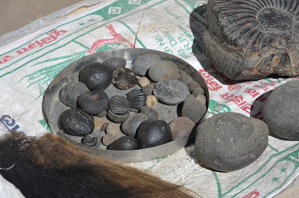
Walk up the Kali Gandaki valley in Mustang, past Jomsom towards Muktinath, and you may find a smooth black stone in the river bed. Crack it open along its middle and inside lies a coiled shell, spiraling like a ram’s horn. Pilgrims call these stones shaligrams and carry them home to keep in their shrines. Geologists call the coiled shells ammonites: sea animals, relatives of today’s squid and octopus, that lived in the oceans about 150 million years ago and died out with the dinosaurs.
So what is a sea animal doing nearly 3,000 m up in the Himalaya, hundreds of kilometers from the nearest sea? The rock it lies in was once mud on the floor of a sea. Since then, that sea floor has been squeezed, folded and lifted higher than any other land on Earth, and it is still being pushed up today, a little each year, by a push from below that also shakes Nepal with earthquakes. This unit is about the science of that rock: what geology is, the plates that carry the continents, how fold mountains are built, and why the Earth erupts and shakes.
15.1 Meaning and importance of geology
Geology is the study of the Earth: what it is made of (its rocks and minerals), how it is built inside, the processes that shape and change it, and its history over 4.6 billion years. The word comes from two Greek words, gē, the Earth, and logos, study. A scientist who studies geology is a geologist. The subject has many branches: mineralogy studies minerals, petrology rocks, paleontology fossils, structural geology how rocks are folded and broken, seismology earthquakes, and engineering geology the rock and soil under roads, tunnels and dams.
Importance of geology
Geology matters more in Nepal than in most countries, because the land here is young, steep and still moving.
a. Finding resources. Every mineral, from the limestone in cement to the iron of Phulchoki and the gems of the eastern hills, is found by geologists who know which rocks hold what. So are groundwater, building stone, sand and gravel, and oil and gas.
b. Building safely. Before a road, a bridge, a dam, a tunnel or a hydropower project is built, engineering geologists study the rock and soil it will stand on: how strong they are, how they are cracked, whether water flows through them. A tunnel driven through weak, broken rock without that study can collapse.
c. Reducing disasters. Landslides, earthquakes, floods from glacial lakes and the sinking of land are all geological. Maps of where the ground is weak, where faults run and where slopes may fail tell people where not to build, and where to build more carefully.
d. Understanding the past. Rocks and fossils record the Earth’s history: old seas, ice ages, the coming and going of animals and plants, and the changes of climate. That history helps us understand the changes happening now.
e. Farming and the environment. Soil is made from rock, and its kind depends on the rock below. Geology also shows where pollution can seep into groundwater, and how rivers move their sand and gravel.
Which branch of geology studies fossils?
Pick an answer to see why.
15.2 Tectonic plates
In Grade 6 you met the Earth’s layers: a thin rocky crust, a thick mantle of hot rock below it, and a core of iron and nickel at the center. For plates, one more division matters. The crust and the topmost, cooler part of the mantle are stiff, and together they form a rigid shell about 100 km thick, the lithosphere (Greek lithos, stone). Below it, the rock of the mantle is so hot that, although it is solid, it can creep very slowly, like very stiff toffee: this soft layer is the asthenosphere (Greek asthenēs, weak).
The lithosphere is not one unbroken shell. It is cracked into large pieces that fit together like the pieces of a broken eggshell. These pieces are the tectonic plates (or lithospheric plates), and they ride on the soft asthenosphere, moving slowly relative to one another. The word tectonic comes from the Greek tektōn, a builder: the plates build the mountains, the ocean basins and the continents.
There are seven or eight large plates and many smaller ones:
| Large plates | Some smaller plates |
|---|---|
| Pacific, North American, South American, Eurasian, African, Antarctic, Indo-Australian (often counted as two, the Indian and the Australian) | Arabian, Philippine Sea, Nazca, Cocos, Caribbean, Juan de Fuca, Scotia |
A plate may carry a continent, ocean floor, or both. Continental crust is thick (about 35 km, and up to about 70 km under the Himalaya and Tibet) and made of lighter rock, mostly like granite. Oceanic crust is thin (about 7 km) and made of heavier rock, mostly basalt. That difference in weight decides what happens when two plates meet.
Plates move at about 2 to 10 cm a year, about as fast as your fingernails grow. That sounds slow, but in a million years 5 cm a year adds up to 50 km, and in 50 million years to 2,500 km.
Why do plates move?
The heat inside the Earth, left from its formation and made by radioactive atoms in its rocks, keeps the mantle slowly churning. Hot rock deep in the mantle rises, cooler rock sinks, and the flow drags on the plates. But the strongest push and pull come from the plates themselves. Where old sea floor, cold and heavy, sinks back into the mantle, it pulls the rest of its plate after it, like a tablecloth sliding off a table when one end hangs over the edge (slab pull). And at the ridges in the middle of the oceans, where new sea floor forms high and hot, the plates slide away downhill (ridge push).
Where plates meet
Most of the action happens at the edges of the plates, their boundaries, where they meet. There are three kinds, according to how the plates move against each other.
a. Divergent boundaries: the plates move apart. As they part, the pressure on the hot mantle below drops, some of it melts, and the melted rock rises to fill the gap, making new crust. Under the oceans this builds the mid-ocean ridges, long chains of undersea mountains with a crack along the top; the Mid-Atlantic Ridge rises above the sea in Iceland. On land, a continent can split apart in a rift valley, as along the East African Rift.
b. Convergent boundaries: the plates move towards each other. What happens depends on what they carry.
- Where sea floor meets a continent (or other sea floor), the heavier oceanic plate bends down and sinks under the other plate into the mantle. This is called subduction. A deep trench forms in the sea floor, and as the sinking plate releases water into the hot mantle above it, the rock melts and rises as a line of volcanoes: the Andes, Japan, Indonesia.
- Where a continent meets a continent, neither sinks far, because continental crust is too light. The crust crumples, folds, breaks and piles up into high mountains. This is how the Himalaya were built, as India pushed into Asia.
c. Transform boundaries: the plates slide past each other sideways. Crust is neither made nor destroyed, but the plates often stick and then jerk, causing earthquakes. The San Andreas Fault in California is the best-known example.
| Divergent | Convergent | Transform | |
|---|---|---|---|
| Plates move | apart | towards each other | past each other |
| Crust | new crust made | crust destroyed (sinks) or piled up | neither made nor destroyed |
| Landforms | mid-ocean ridges, rift valleys | trenches, volcanic mountains, fold mountains | faults that offset rivers and roads |
| Earthquakes | shallow, mostly small | the largest on Earth | shallow, often strong |
| Volcanoes | yes, many | yes where sea floor sinks; few where continents collide | rare |
| Example | Mid-Atlantic Ridge, Iceland, East African Rift | Andes, Japan; the Himalaya | San Andreas Fault |
At which kind of boundary is new crust made?
Pick an answer to see why.
Nepal on its plate
Nepal sits on the meeting of two plates. The Terai and most of the rock of the hills belong to the Indian plate; Tibet, north of the Himalaya, lies on the Eurasian plate. India is still moving north, at about 4 to 5 cm a year, and about 2 cm a year of that is taken up across Nepal itself, by the squeezing of its rocks. The rest squeezes Tibet and the land beyond.
To see the plates on a globe, Our World’s Earth Through Time shows the land from a billion years ago to 50 million years from now, and follows a yellow dot, the rocks under Kathmandu, from the far south, where India lay beside Africa and Antarctica, to where they are today. Earthquakes and Plates draws every plate boundary and every large earthquake since 1900: see how closely the earthquakes follow the boundaries.
15.3 Process of formation of a fold mountain
Mountains form in more than one way: some are blocks of crust lifted between faults, some are piles of lava and ash round a volcano. But the highest and longest ranges on Earth, the Himalaya, the Andes and the Alps, are fold mountains, made where two plates converge and squeeze layers of rock between them.
Folds
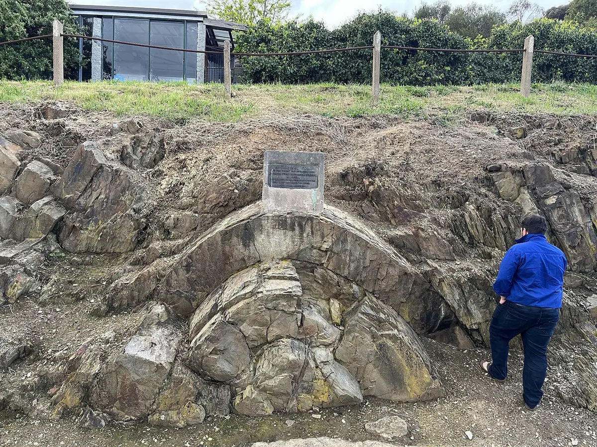
Push a tablecloth across a table and it wrinkles into ridges and hollows. Layers of rock squeezed from the sides do the same, very slowly, over millions of years. The rock bends instead of breaking because it is deep, hot and under great pressure from the rock above, so it behaves less like a brittle biscuit and more like soft clay. A bend in layers of rock is a fold.
The parts of a fold:
- An anticline is an upfold, an arch, with its layers sloping down away from its middle. Its highest point is the crest.
- A syncline is a downfold, a trough, with its layers sloping down towards its middle. Its lowest point is the trough.
- The two sloping sides of a fold are its limbs.
- The axial plane is the imaginary surface that divides a fold into two halves as equally as possible, passing through its bend.
As the squeeze grows stronger, the folds become tighter and lean over:
a. Symmetrical fold: the axial plane is upright and the two limbs slope equally. It forms when the push from both sides is about equal.
b. Asymmetrical fold: the axial plane leans, and one limb is steeper than the other.
c. Overturned fold: one limb is pushed past upright, so the layers on that side are upside down, the older rock on top of the younger.
d. Recumbent fold: the fold has been pushed over so far that it lies on its side, its axial plane almost flat.
When the push is too strong for even hot, deep rock to bend, it breaks. A break along which the rock on one side has moved is a fault. In a fold mountain range, folds are usually broken by faults called thrusts, low-angle faults along which great sheets of rock are pushed up and over the rock in front of them, like roof tiles stacked one over another.
The widget shows why squeezing makes mountains: the layers keep their length, so a pile pushed into a narrower space must rise. In real mountains the squeezed rock also thickens and stacks along thrusts, and the crust beneath grows deep roots, so the land rises even more.
How the Himalaya were built
A fold mountain range forms in stages, which the Himalaya show well.
a. A sea fills with sediment. About 200 million years ago, a wide ocean, the Tethys Sea, lay between India and Asia. India was then far to the south, part of a great southern continent called Gondwana. Rivers carried mud and sand into the sea, and shells of sea animals, ammonites among them, piled up on its floor. Over tens of millions of years these layers, thousands of meters thick, hardened into shale, sandstone and limestone.
b. The plates converge. India broke away from Gondwana and moved north. The floor of the Tethys sank under the southern edge of Asia, and as it sank the sea grew narrower.
c. The continents collide. About 50 million years ago, the last of the Tethys sea floor sank, and India hit Asia. Continental crust is too light to sink, so the layers of sediment caught between the two continents were squeezed from both sides. They folded, broke along thrusts, and were pushed up and over one another, while the top of India was sliced off and stacked into the growing range.
d. The mountains rise and wear down. India kept pushing, so the range kept rising and growing wider. At the same time, rain, frost, ice and rivers wore it down and carried the rock south as sand and gravel, which built the plains in front of it. The two contests continue today.
That is why the fossils of sea animals are found high in the Himalaya: the shaligrams of the Kali Gandaki come from rocks laid down on the floor of the Tethys, and the rock at the very top of Sagarmatha (Mount Everest), 8,848.86 m high, is a limestone made on the floor of a warm, shallow sea about 450 million years ago.
The ranges of Nepal
Go from south to north across Nepal and you cross the Himalaya’s belts, separated by great faults that run the length of the range.
a. The Terai: flat plains of sand, gravel, silt and clay, washed down from the mountains by rivers. Under them lies the solid rock of the Indian plate, buried by thousands of meters of sediment.
b. The Chure (Siwalik) hills: the youngest hills, made of the sand, gravel and mud that rivers carried out of the rising Himalaya over the last 20 million years or so, then caught up in the push, folded and lifted into hills themselves. Their rock is soft and crumbly, which is why the Chure suffers so badly from erosion.
c. The Mahabharat range and the hills (the Lesser Himalaya): older sedimentary rock, much of it changed by heat and pressure into slate, phyllite, schist and quartzite, with limestone and dolomite. Phulchoki (2,782 m), at the southern edge of the Kathmandu valley, is part of it.
d. The Higher Himalaya: the great snow peaks, Kanchenjunga, Makalu, Dhaulagiri, Annapurna, made of rock that was once buried deep in the crust and changed into gneiss and marble, cut by light-colored granite that crystallized from rock melted deep inside the range.
e. The Tethys Himalaya: north of the main peaks, in Mustang, Manang and Dolpa, layers of limestone, shale and sandstone from the old Tethys sea floor, full of fossils. Everest’s summit, though it stands on the main range, is a cap of this rock.
The great thrusts between these belts are, from south to north, the Main Frontal Thrust (between the Terai and the Chure), the Main Boundary Thrust (between the Chure and the Lesser Himalaya) and the Main Central Thrust (between the Lesser and the Higher Himalaya). (The Tethys Himalaya is separated from the Higher Himalaya by a different kind of fault, along which the rock above slid down to the north.) Under them all, India slides north beneath Nepal along one great fault, the Main Himalayan Thrust, which Section 15.5 returns to.
Rocks and minerals of the Himalayan region
The belts of Nepal’s mountains have different rocks, and different rocks hold different minerals. Each belt was made in its own way: the Terai from the sand and mud rivers bring down today; the Chure from the same, a few million years older; the hills from old sediment changed by heat and pressure; the Higher Himalaya from rock changed so deeply that some of it melted; the Tethys Himalaya from sea-floor sediment that was lifted without being changed much, so its fossils survive.
Your Grade 7 book has a table of the main rocks of Nepal Grade 7: Some main rocks of Nepal, and your Grade 8 book a table of Nepal’s minerals Grade 8: Minerals in Nepal. Geography, for the Curious tells how Nepal’s minerals were found and why most are still waiting to be mined, in Nepal’s Soil, Minerals and Water; how one rock turns into another is in Going Further 6–8, How Does One Rock Become Another?, and how geologists date rocks in How Do Rocks Tell Time?
In which belt of Nepal are fossils of sea animals most common?
Pick an answer to see why.
15.4 Volcanic eruptions
A volcano is an opening in the Earth’s crust through which melted rock, ash and gases come out from inside the Earth, and also the mountain built around that opening by what comes out. The coming out is an eruption.
Melted rock under the ground is called magma. When it reaches the surface and flows out, it is called lava. Magma collects in a magma chamber a few kilometers under the volcano, and rises to the surface through a pipe called the vent. The bowl-shaped hollow at the top of the vent is the crater. A very large crater, kilometers across, formed when the top of a volcano collapses into its emptied magma chamber, is a caldera.
What comes out of a volcano:
- Lava: runny lava, poor in silica, flows far and fast, sometimes many kilometers; sticky lava, rich in silica, hardly flows and piles up near the vent.
- Gases: mostly water vapor, with carbon dioxide and sulphur dioxide.
- Pyroclastic material (Greek pyr, fire, and klastos, broken): pieces of rock and frozen lava thrown out by the blast, from fine ash through pebbles to volcanic bombs, lumps of lava that cool as they fly. Light, frothy lava full of gas bubbles cools into pumice, a rock so light that it floats.
Kinds of volcano
By how often they erupt, volcanoes are:
a. Active: erupting now, or erupted in recent history and likely to erupt again. Examples: Kilauea and Mauna Loa (Hawaii), Etna (Italy), Pinatubo (the Philippines).
b. Dormant (sleeping): not erupted for a long time, but could erupt again. Mount Fuji in Japan last erupted in 1707.
c. Extinct: not expected ever to erupt again, because its supply of magma has gone. Arthur’s Seat in Edinburgh, Scotland, is the worn-down remains of a volcano about 340 million years old.
By their shape, which depends mostly on how runny their lava is:
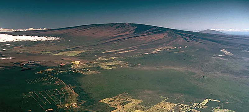
a. Shield volcanoes: broad, gently sloping mountains, like a warrior’s shield lying on the ground, built by runny lava flowing far from the vent. Mauna Loa in Hawaii, the largest active volcano on Earth, rises about 9 km from the sea floor.
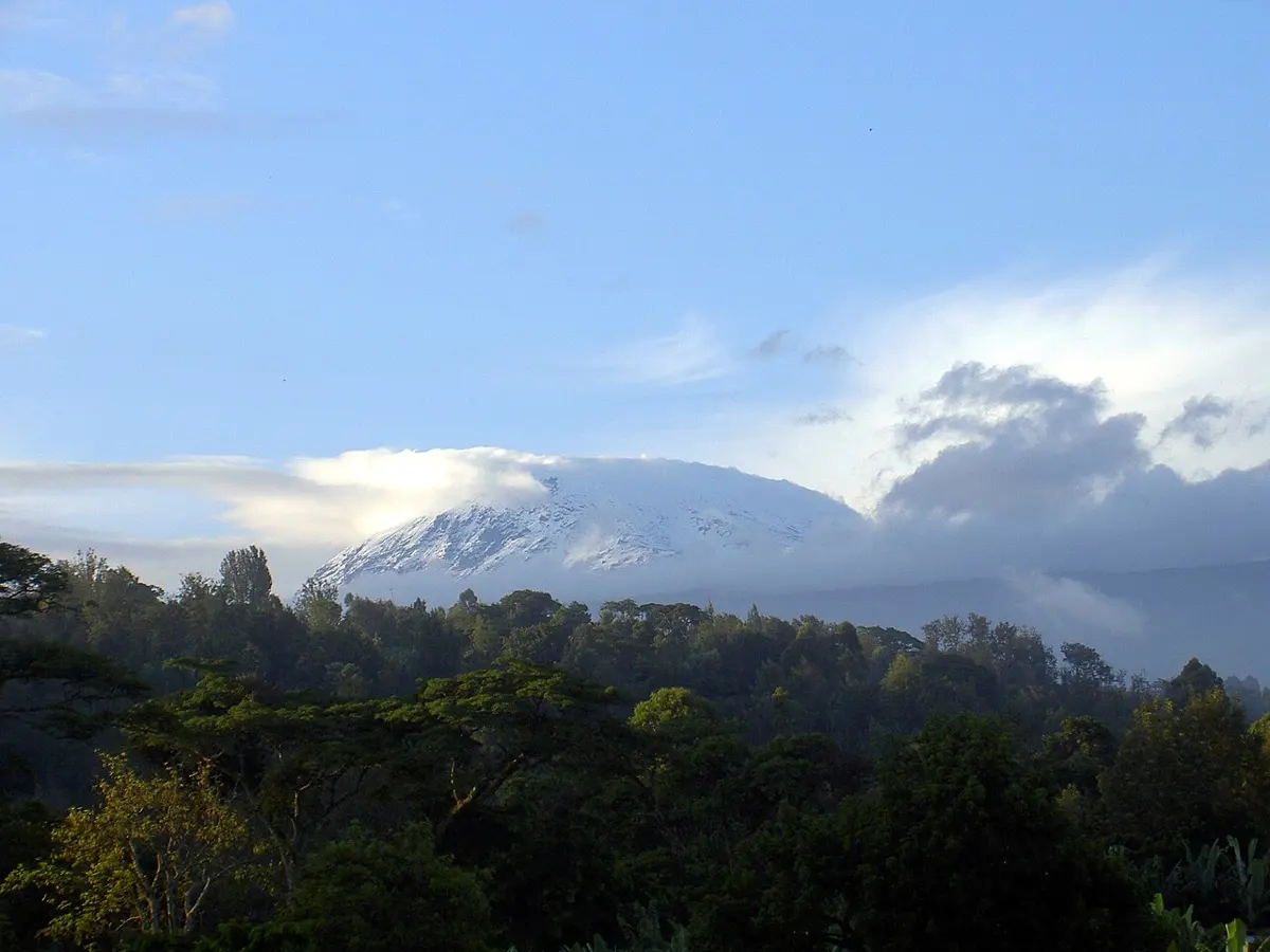
b. Composite volcanoes (stratovolcanoes): tall, steep, cone-shaped mountains built of layers of sticky lava and ash, one over another. They erupt explosively. Fuji, Kilimanjaro and Pinatubo are composite volcanoes.
c. Cinder cones: small, steep cones of loose cinders and ash round a single vent. In 1943 a cinder cone, Parícutin, rose out of a farmer’s cornfield in Mexico and grew more than 300 m high in a year.
Causes of volcanic eruptions
The mantle is hot enough to melt, but almost all of it is solid, because the weight of the rock above presses on it. Rock melts into magma in three ways:
a. The pressure drops: where plates pull apart, at mid-ocean ridges and rift valleys, hot mantle rises into the gap, and as the pressure on it falls, some of it melts.
b. Water is added: where an ocean plate sinks under another plate, it carries water down in its minerals. Deep down, the water is squeezed out into the hot mantle above, and lowers its melting point, as salt lowers the melting point of ice. The mantle melts and the magma rises. This makes the lines of volcanoes beside the trenches.
c. Extra heat rises: at a few places called hot spots, unusually hot rock rises from deep in the mantle, in a column called a plume, and melts as it nears the surface, wherever the plate above happens to be. Hawaii, in the middle of the Pacific plate, sits over one.
Once formed, magma is lighter than the solid rock around it, so it rises, like a drop of oil in water, and gathers in a magma chamber. It is full of dissolved gas, mostly water vapor, held in by the pressure, as carbon dioxide is held in a sealed bottle of soda. As the magma rises and the pressure on it drops, the gas comes out as bubbles; as more magma gathers, the pressure in the chamber builds; and when it is greater than the strength of the rock above, the magma breaks through to the surface: an eruption. Runny magma lets its gas escape easily and erupts quietly as lava flows. Sticky magma traps its gas until it bursts out explosively, like a shaken soda bottle opened all at once.
So volcanoes are found in three kinds of place: along divergent boundaries, along convergent boundaries where sea floor sinks, and over hot spots. Most of the world’s active volcanoes on land are in a ring round the Pacific Ocean, where sea floor sinks under the plates around it: the Ring of Fire. About 1,350 volcanoes on Earth are thought able to erupt again, not counting those along the ridges under the sea, and about 500 of them have erupted in recorded history.
Effects of volcanic eruptions
On people and the environment, harmful:
a. Lava flows burn and bury everything in their path: houses, roads, fields and forests. They are usually slow enough for people to walk away from them.
b. Pyroclastic flows: avalanches of hot ash, rock and gas, at hundreds of degrees, racing down a volcano’s side faster than a car. They are the deadliest danger. In AD 79, Vesuvius in Italy buried the Roman towns of Pompeii and Herculaneum, and more than a thousand people died.
c. Ash falls: ash, made of tiny sharp pieces of rock and glass, falls like gray snow, breaks roofs under its weight, ruins crops, poisons water, harms the lungs and stops aircraft engines.
d. Lahars: mudflows of ash and water, when an eruption melts a volcano’s snow and ice, or heavy rain falls on loose ash. In 1985 an eruption of Nevado del Ruiz in Colombia melted its ice cap, and the lahars that rushed down its valleys buried the town of Armero, killing about 23,000 people.
e. Gases: carbon dioxide and sulphur dioxide can suffocate people and animals, and sulphur dioxide makes acid rain.
f. Tsunamis: an eruption under or beside the sea can set off huge waves. When Krakatoa, in Indonesia, exploded in 1883, the eruption and its waves killed more than 36,000 people, most of them drowned on the coasts nearby.
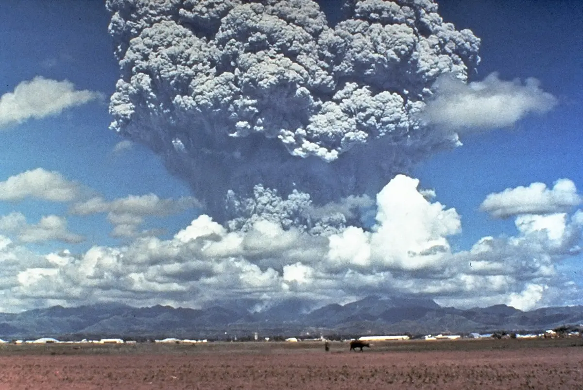
g. Changes in climate: a big eruption blows sulphur dioxide high into the air, where it forms a haze of tiny drops that reflects sunlight and cools the whole Earth for a year or two. After Pinatubo erupted in June 1991, the Earth cooled by about 0.5 °C. After Tambora, in Indonesia, erupted in April 1815, 1816 was called “the year without a summer” in Europe and North America, with frost in summer and failed harvests.
Useful:
a. Fertile soil: volcanic ash weathers into rich soil, which is why farms crowd the slopes of volcanoes in Java, Italy and Japan.
b. Geothermal energy: the heat of magma near the surface heats underground water into steam, which drives turbines for electricity. Iceland makes much of its electricity and heats most of its homes this way.
c. Minerals and building materials: many deposits of metals such as copper and gold formed from hot fluids around old magma chambers; sulphur collects round vents; pumice and volcanic stone are used in building.
d. New land: volcanoes made Hawaii, Iceland and many other islands, and still add to them.
Measures to reduce the impacts of volcanic eruptions
An eruption can’t be stopped, but its harm can be made much smaller.
a. Watch the volcano. Before an eruption, magma moving up causes swarms of small earthquakes, makes the ground swell, and lets out more gas. Seismometers, GPS stations, satellites and gas sensors around an active volcano can warn of an eruption days or weeks ahead.
b. Map the hazards. Maps of where lava, pyroclastic flows, lahars and ash have gone in past eruptions show where they will most likely go next. Schools, hospitals and new houses should be built outside those areas, and not in the valleys lahars follow.
c. Plan the evacuation. People living near a volcano need warnings they understand, routes out, places to go, and practice. Evacuation is what saves most lives.
d. Protect against ash. Sweep ash off roofs before it piles up, wear masks, cover water tanks, keep animals indoors, and keep aircraft away from ash clouds.
e. Divert or slow lava. Walls and channels have turned lava flows away from towns, and in Iceland in 1973 seawater sprayed on a lava flow helped save a harbor.
Why does sticky magma erupt more explosively than runny magma?
Pick an answer to see why.
15.5 Earthquakes
An earthquake is a sudden shaking of the ground, caused by waves of energy released when rock breaks or slips deep below the surface.
The rock of the crust is elastic: it bends a little under force and springs back when the force is removed, like a stick bent between your hands. Where two plates push or slide against each other, the rock along a fault is stuck by friction, so as the plates move it is bent and squeezed, storing energy, year after year, for decades or centuries. When the force becomes greater than the friction, the fault suddenly slips, in seconds, and the bent rock on both sides springs back. The stored energy is released as waves that shake the ground. This explanation is the elastic rebound theory, put forward by the American geologist Harry Fielding Reid after the San Francisco earthquake of 1906, when fences and roads across the San Andreas Fault were found shifted by several meters.
- The focus (or hypocenter) is the point inside the Earth where the rock first slips and the earthquake begins.
- The epicenter is the point on the Earth’s surface directly above the focus. The shaking is usually strongest near it.
- The depth of focus is the distance from the focus up to the epicenter. Most earthquakes begin less than 70 km deep, and shallow ones do the most harm. Nepal’s big earthquakes begin 10 to 20 km down.
- The waves of energy that travel out from the focus are seismic waves (Greek seismos, shaking).
Seismic waves
An earthquake sends out three main kinds of wave.
a. P waves (primary waves) are the fastest, about 6 km/s in the crust, and arrive first. They push and pull the rock in the direction they travel, like a sound wave, and can pass through solids, liquids and gases.
b. S waves (secondary waves) arrive next, at about 3.5 km/s. They shake the rock from side to side, at right angles to their direction, and can pass only through solids. (That they don’t cross the Earth’s outer core is how we know it is liquid.)
c. Surface waves travel along the surface, slowest of all, and roll and sway the ground. They usually do the most damage to buildings.
A seismograph records the waves: its trace, a seismogram, shows the P waves, then the S waves, then the large surface waves. The farther the station is from the earthquake, the longer the gap between the P and the S waves, because the faster P waves pull further ahead. In the crust, each second of gap means about 8.4 km of distance (the example below shows why), and with three stations, the epicenter can be found where their three circles meet.
Measuring earthquakes: magnitude and intensity
Every earthquake gets two kinds of number, which measure different things.
Magnitude is the size of the earthquake at its source, the energy it released. Each earthquake has one magnitude. The first magnitude scale was worked out in 1935 by the American seismologist Charles Richter, from how far the needle of a seismograph swung, so it is often called the Richter scale. Seismologists now use the moment magnitude, worked out from how large an area of the fault slipped and by how much, which works for the biggest earthquakes too; for most earthquakes the two give about the same number. The scale is logarithmic:
- each whole step up the scale means waves 10 times higher on a seismograph, and
- about 32 times as much energy released (more exactly ).
So an earthquake of magnitude 8 is not a little bigger than one of magnitude 7: it releases about 32 times as much energy, and about 1,000 times as much as one of magnitude 6.
where and are the energies of the two earthquakes and is the difference between their magnitudes.
Intensity is how strongly the shaking is felt at one place, judged by what people felt and what was damaged. It is different from place to place, strongest near the epicenter and on soft ground. It is measured on the Modified Mercalli scale, written in Roman numerals, from I (felt by almost nobody) to XII (almost everything destroyed). In 2015 it reached VIII to IX in most of the Kathmandu valley, while in Patna, in India, it was only V.
| Magnitude | Intensity | |
|---|---|---|
| Measures | the energy released at the source | the shaking and damage at a place |
| Values for one earthquake | one | different at each place |
| Found from | seismographs | what people felt and what was damaged |
| Scale | Richter or moment magnitude, in decimals (7.8) | Modified Mercalli, in Roman numerals (I–XII) |
How magnitudes are calculated, and why the scale is logarithmic, is in Math, Going Further 9–12: Why Is a Magnitude 8 Earthquake Not Just a Bit Bigger Than a 7? How often Nepal shakes, and how many small earthquakes there are for each big one, is in Computing, Going Further 9–12: How Often Does Nepal Shake?
Causes of earthquakes
a. Tectonic earthquakes: the slipping of faults as plates move, as explained above. Almost all large earthquakes are tectonic, and most happen along plate boundaries.
b. Volcanic earthquakes: magma forcing its way up through the rock under a volcano cracks the rock and causes earthquakes, usually small ones, often before an eruption.
c. Collapse earthquakes: small tremors when the roof of a cave or an old mine falls in, or a large landslide crashes down.
d. Earthquakes caused by people (induced earthquakes): filling a large reservoir behind a dam, which presses on the rock and pushes water into its cracks; mining; pumping fluids deep underground; and underground nuclear tests. The earthquake of 1967 near the Koyna dam in India is the best-known case linked to a reservoir.
Earthquakes in Nepal
Nepal lies over the Main Himalayan Thrust, the great fault along which India slides north under the Himalaya. Below about 20 km, the rock is hot enough to creep, and India slides on steadily. Above that, the fault is stuck. So the rock above it is bent and squeezed, year after year, by the 2 cm a year of India’s push, like a spring being wound, and the high Himalaya is pushed up. Every century or two, a stretch of the fault can’t hold any longer and slips, a few meters in a few seconds: a great earthquake.
Some of Nepal’s big earthquakes:
| Date | Where | Magnitude | What happened |
|---|---|---|---|
| 1255 (1312 BS) | Kathmandu valley | not known | chronicles say about a third of the valley’s people died, King Abhaya Malla among them |
| 15 January 1934 (2 Magh 1990 BS) | eastern Nepal and Bihar | 8.0 | Nepal’s worst on record: 8,519 died in Nepal; much of Bhaktapur fell, and the Dharahara was broken |
| 21 August 1988 (5 Bhadra 2045 BS) | Udayapur | 6.9 | more than 700 died in Nepal; Nepal’s building code followed |
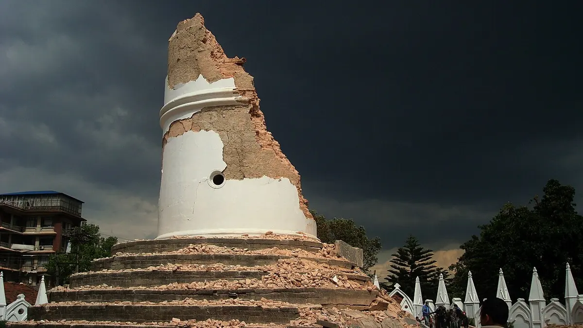
| 25 April 2015 (12 Baisakh 2072 BS) | Barpak, Gorkha | 7.8 | nearly 9,000 died and about 22,000 were injured; the Dharahara and many temples fell |
| 12 May 2015 (29 Baisakh 2072 BS) | Dolakha | 7.3 | the largest aftershock of Gorkha |
| 3 November 2023 (17 Kartik 2080 BS) | Jajarkot | 5.7 | about 150 died, many of them children |
The Gorkha earthquake began about 8 to 15 km under Barpak (estimates differ), and the fault unzipped eastwards for about 150 km, under Kathmandu. It broke only the deeper part of the stuck fault; the shallow part, between Kathmandu and the Terai, still holds its strain. Going Further 9–12 follows it in Why Is Everest Still Rising?
Effects of earthquakes
On people:
a. Buildings fall. Most deaths in earthquakes are caused not by the shaking itself but by buildings collapsing on the people inside: heavy walls of stone, brick or mud without anything to tie them together, and concrete buildings built without enough steel.
b. Injuries, homelessness and disease: thousands are hurt and many more lose their homes, often in winter or the monsoon; broken water pipes and crowded camps spread disease.
c. Loss of heritage: in 2015 the Dharahara, the Kasthamandap and many temples in the Durbar Squares of Kathmandu, Patan and Bhaktapur fell or were badly damaged.
d. Economic loss: roads, bridges, schools, hospitals, power lines and water supplies are destroyed; businesses and tourism stop; rebuilding takes years and costs billions.
On the environment:
a. Landslides and avalanches: in a steep country like Nepal, shaking brings down whole hillsides. In 2015 an avalanche of ice and rock buried the village of Langtang, and thousands of landslides blocked roads and rivers.
b. Dammed rivers and floods: a landslide can block a river, and the lake behind it may burst later, flooding the valley below.
c. Cracks, uplift and sinking: the ground may crack, rise or sink; springs may dry up and new ones appear.
d. Liquefaction: wet, loose sand shaken hard behaves like a liquid, and buildings on it tilt and sink.
e. Tsunamis: an earthquake under the sea can lift the sea floor and the water above it, setting off waves that cross whole oceans. In 2004 a tsunami from an earthquake off Sumatra killed more than 200,000 people around the Indian Ocean.
f. Fires: from broken gas lines, power lines and cooking fires.
Measures to reduce the impacts of earthquakes
Earthquakes can’t be stopped or, as yet, predicted: nobody can say when and where the next one will come, only where they are likely and roughly how often. But most of their harm can be prevented, because it comes from what falls.
Before an earthquake:
a. Build safely. Follow the National Building Code. Its seismic design code, NBC 105, was first published in 1994, after the Udayapur earthquake, and rewritten in 2020, after Gorkha. A safe house has a firm foundation; walls tied together by bands of reinforced concrete or wood at the plinth, the lintels and the roof; steel bars that join columns and beams; a light roof fixed to the walls; and a simple, regular shape.
b. Strengthen old buildings (retrofitting), especially schools and hospitals, which must stay standing to be used afterwards.
c. Plan land use. Don’t build on steep, loose slopes, on soft filled ground or beside rivers that a landslide might dam. Keep open spaces in towns, where people can gather and shelter.
d. Make homes and schools safe inside. Fix tall cupboards and shelves to the wall, keep heavy things low, and know where the safe places are, under a strong table, away from windows.
e. Prepare. Keep a bag with water, dry food, a torch, a whistle, medicines and copies of important papers. Agree where your family will meet. Practice earthquake drills at school. Nepal marks Earthquake Safety Day on 2 Magh every year, the day of the 1934 earthquake, to remind people.
f. Watch and warn. Seismographs across the country record every earthquake, and the National Seismological Centre reports them within minutes. Some countries, such as Japan, have early warning systems that detect the first, harmless P waves and send an alert to phones and trains a few seconds before the damaging shaking arrives.
During an earthquake:
a. Indoors: Drop, Cover and Hold On: drop to your hands and knees, take cover under a strong table or desk, or beside an inner wall away from windows, and hold on until the shaking stops. Don’t run outside while the ground is shaking: many are hurt by falling glass and bricks as they run.
b. Outdoors: move to an open space away from buildings, walls, trees, electric poles and slopes.
c. In a vehicle: stop away from bridges, buildings and slopes, and stay inside.
After an earthquake:
a. Expect aftershocks. Go out carefully to an open space once the shaking stops, and don’t go back into a damaged building.
b. Help the injured, turn off gas and electricity if you can, and use the phone only for emergencies.
c. Listen to the radio for news and instructions, and keep away from slopes where landslides may fall.
Going Further 9–12 has you test house designs on a shaking table in Can You Design an Earthquake-Safe House?; Going Further 6–8 explains why earthquakes can’t be forecast as weather can, in Can We Tell When Disaster Will Strike?; and Geography, for the Curious, why two earthquakes of the same size can do very different harm, in Disasters.
Which of these is the safest thing to do indoors while the ground is shaking?
Pick an answer to see why.
Exercise
1. Choose the correct option
a. The tectonic plates are pieces of the:
Pick an answer to see why.
b. The Himalaya were formed by the collision of the:
Pick an answer to see why.
c. An upfold in layers of rock is called:
Pick an answer to see why.
d. A fold lying almost flat on its side is:
Pick an answer to see why.
e. Melted rock that has come out on the Earth’s surface is called:
Pick an answer to see why.
f. Mount Fuji, which last erupted in 1707, is an example of:
Pick an answer to see why.
g. The point on the Earth’s surface directly above the focus of an earthquake is the:
Pick an answer to see why.
2. Give reasons
Fossils of sea animals are found high in the Himalaya.
Hint
Answer
There are no volcanoes in Nepal, though there are many earthquakes.
Hint
Answer
Most volcanoes and earthquakes occur along the boundaries of the plates.
Hint
Answer
Earthquakes are more dangerous in Nepal than in many other countries.
Hint
Answer
Building houses according to the building code reduces the loss of life in earthquakes.
Hint
Answer
3. Differentiate between
Anticline and syncline
Hint
Answer
Magma and lava
Hint
Answer
4. Answer the following questions
What is geology? Write any three reasons why its study is important for Nepal.
Hint
Answer
What are tectonic plates? Name any four major plates.
Hint
Answer
Describe the three kinds of plate boundary, with an example of each.
Hint
Answer
Describe the process of formation of a fold mountain, with reference to the Himalaya. Draw a labeled diagram of a fold.
Hint
Answer
What is a volcano? Explain the causes of a volcanic eruption.
Hint
Answer
Write any three harmful and two useful effects of volcanic eruptions.
Hint
Answer
Suggest any four measures to reduce the impacts of volcanic eruptions.
Hint
Answer
What is an earthquake? Explain how an earthquake occurs, using the elastic rebound theory.
Hint
Answer
Write any four effects of earthquakes on people and the environment.
Hint
Answer
Suggest any five measures to reduce the impacts of earthquakes in Nepal.
Hint
Answer
Why does the Himalaya keep rising, and why does Nepal have big earthquakes every century or two? Explain with the help of the Main Himalayan Thrust.
Hint
Answer
5. Numerical problems
The Atlantic Ocean widens by about 2.5 cm a year. By how many kilometers will it widen in 10 million years?
Hint
Answer
A plate has moved 1,800 km in 40 million years. Find its average speed in cm per year.
Hint
Answer
A layer of rock, 50 km long, is squeezed and folded until its ends are 35 km apart. (a) Find the shortening in km and as a percentage. (b) If the squeezing happened at 1.5 cm a year, how long did it take?
Hint
Answer
Earthquake A has a magnitude of 7.0 and earthquake B of 5.0. How many times (a) higher are A’s waves on a seismograph, and (b) more energy does A release?
Hint
Answer
At a seismograph station, the S waves of an earthquake arrive 20 seconds after the P waves. Taking the speed of P waves as 6 km/s and of S waves as 3.5 km/s, find the distance of the earthquake’s focus from the station.
Hint
Answer
Think: Your friend says, “The Himalaya are so high that they must be very old mountains, older than the Aravalli hills of India.” Do you agree? Use what you know about how mountains rise and wear down.
Hint
Answer
Printable PDFs
- The unit as a book (A5) 36 pages Answers as an A4 booklet, 9 sheets
- Study notes 3 pages
- Worksheet 5 pages Answer key
- Harder practice questions 2 pages Answer key
Practice every question in the book, and keep track of the ones you miss →
Found a mistake? Please tell us.