
At Muktinath and along the Kali Gandaki, pilgrims pick up shaligrams: smooth black stones that crack open to show a spiral shell inside. The spirals are ammonites, sea animals related to today’s squid and octopus, that lived about 165 to 145 million years ago. They sank into the mud on the floor of a sea called the Tethys, and that mud is now high in the Himalaya.
Here is the strange part. The shaligrams are older than nearly every piece of the deep-ocean floor on the whole Earth. Almost no sea floor anywhere is more than about 200 million years old, and on average it is only about 64 million years old. Yet the continents hold rocks over 4,000 million years old. The oceans themselves are far older than their floors: there have been oceans on the Earth for at least 3,800 million years. So where did the old sea floor go?
The answer is the theory of plate tectonics, and the evidence for it was found on the sea floor itself: in its shape, in its magnetism, and in the mud drilled from it. This topic follows that evidence.
Old continents, young oceans
You met the age of the Earth in Grade 8 Grade 8: Origin and age of the Earth: about 4,600 million years (4.54 billion, more exactly), measured from radioactive atoms in rocks and meteorites, which change into other atoms at a steady rate, like sand running through an hourglass. Measure the rocks of the Earth’s surface the same way and they split into two groups:
| Where | The oldest found | Typical age |
|---|---|---|
| continents | rock: 4,030 million years (Acasta Gneiss, Canada); single grains of the mineral zircon: 4,400 million years (Jack Hills, Australia) | large areas over 2,500 million years |
| sea floor | about 180 million years (western Pacific) | average about 64 million years |
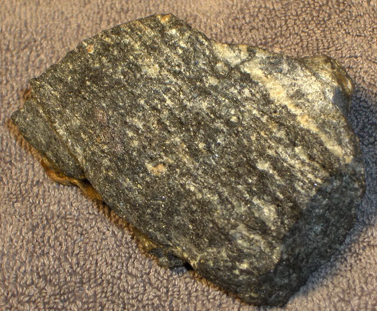
Rocks this old can be measured only because the continents keep them. The sea floor covers about 60% of the Earth’s surface, yet none of it is old. Something must be making new sea floor and getting rid of old sea floor, but leaving the continents alone. To find out what, scientists had to look at the bottom of the sea, which nobody could see.
Which fact shows most clearly that sea floor is destroyed, not just made?
Pick an answer to see why.
Continents that fit
Look at a map of the Atlantic Ocean. The bulge of Brazil would fit into the curve of Africa’s west coast, like pieces of a jigsaw puzzle. Many people noticed this once good maps were made. One man made it into a theory.
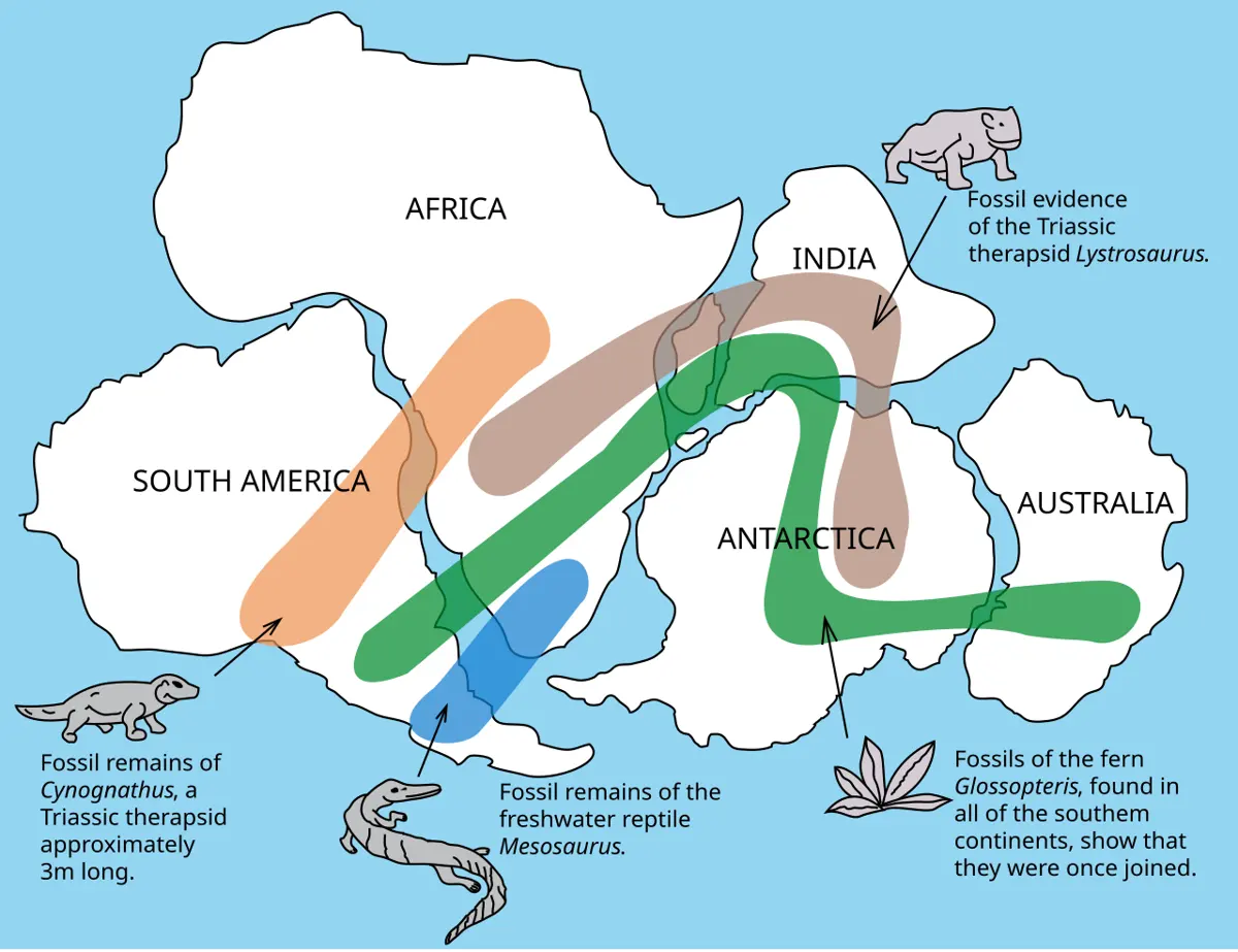
The great southern land that India was part of is called Gondwana, after the Gond region of central India, where its rocks, coal and Glossopteris fossils were first studied. You will meet India’s journey north from Gondwana in Why Is Everest Still Rising? (India meets Asia).
Why did most geologists reject continental drift in Wegener’s time?
Pick an answer to see why.
Mapping the sea floor
Until the 1920s, the depth of the sea was measured by lowering a weighted rope until it touched the bottom: hours for one measurement in the deep ocean. Then ships began to use echo sounding: send a pulse of sound down, and time its echo from the sea floor. Sound travels through sea water at about 1,500 m/s.
By the 1950s ships had crossed the oceans with echo sounders running, and the record was turned into maps. The sea floor was nothing like the flat, muddy plain people had imagined.
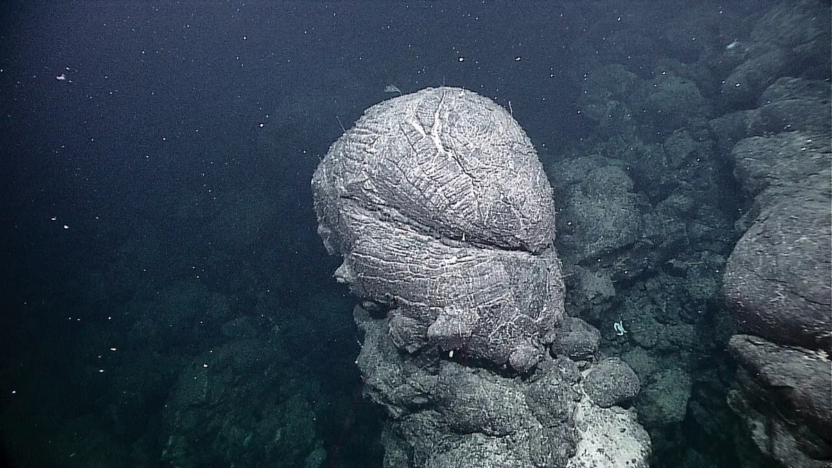
In 1962 the American geologist Harry Hess put the clues together. Hot rock rises from the mantle under the ridges, melts, and erupts as lava, making new sea floor along the rift. The new rock is pulled away on both sides, making room for more. Far away, at the deep ocean trenches, old sea floor sinks back into the mantle. So the sea floor moves like a slow conveyor belt, and the continents ride on it rather than plowing through it. This is sea-floor spreading (a name given by Robert Dietz in 1961). Hess called his own paper “geopoetry”: a good story, but without proof. The proof was hidden in the sea floor’s magnetism.
In Hess’s idea, where is the youngest sea floor?
Pick an answer to see why.
Stripes on the sea floor
You learned in Grade 8 that the Earth is a magnet, because of molten iron moving in its outer core, and that its field has flipped many times: the magnetic north and south poles swap places Grade 8: Why geomagnetism matters. A time when the field points as it does today is called normal; a time when it points the other way, reversed. A flip takes a few thousand years, and they come at irregular times, sometimes a few tens of thousands of years apart, sometimes tens of millions. The last one was 773,000 years ago: early humans living then would have seen their compasses, if they had had any, point south.
How can anyone know? Lava. Volcanic lava contains grains of the magnetic mineral magnetite. When it is hot, the grains are not magnets: heating destroys magnetism, as you saw in Grade 8 Grade 8: Heating the magnet. As the lava cools below a few hundred degrees Celsius (580 °C for pure magnetite; lower for the titanium-rich kind in sea-floor basalt), each grain becomes a tiny magnet lined up with the Earth’s field at that moment, and stays that way when the rock is solid. Every lava flow is a fossil compass. In the 1960s geologists measured the magnetism of lava flows all over the world and dated them, and built a timetable of the field’s flips: the magnetic reversal time scale.
In the 1950s, ships began towing magnetometers, instruments that measure the strength of the magnetic field, across the oceans. Over the sea floor the field was a little stronger in some places and a little weaker in others, and when the measurements were put on a map, the strong and weak places made long stripes, parallel to the mid-ocean ridges. Nobody knew why.
In 1963 the British geologists Fred Vine and Drummond Matthews explained them, using Hess’s idea. If new sea floor is made at the ridge and carried away, then each band of new rock records the field at the time it cooled. Rock made while the field was normal adds to today’s field and makes it a little stronger; rock made while it was reversed makes it a little weaker. Each flip leaves a stripe, and the spreading carries half of it each way. So the stripes on one side of a ridge should be a mirror image of the stripes on the other, and their widths should follow the timetable of the flips.
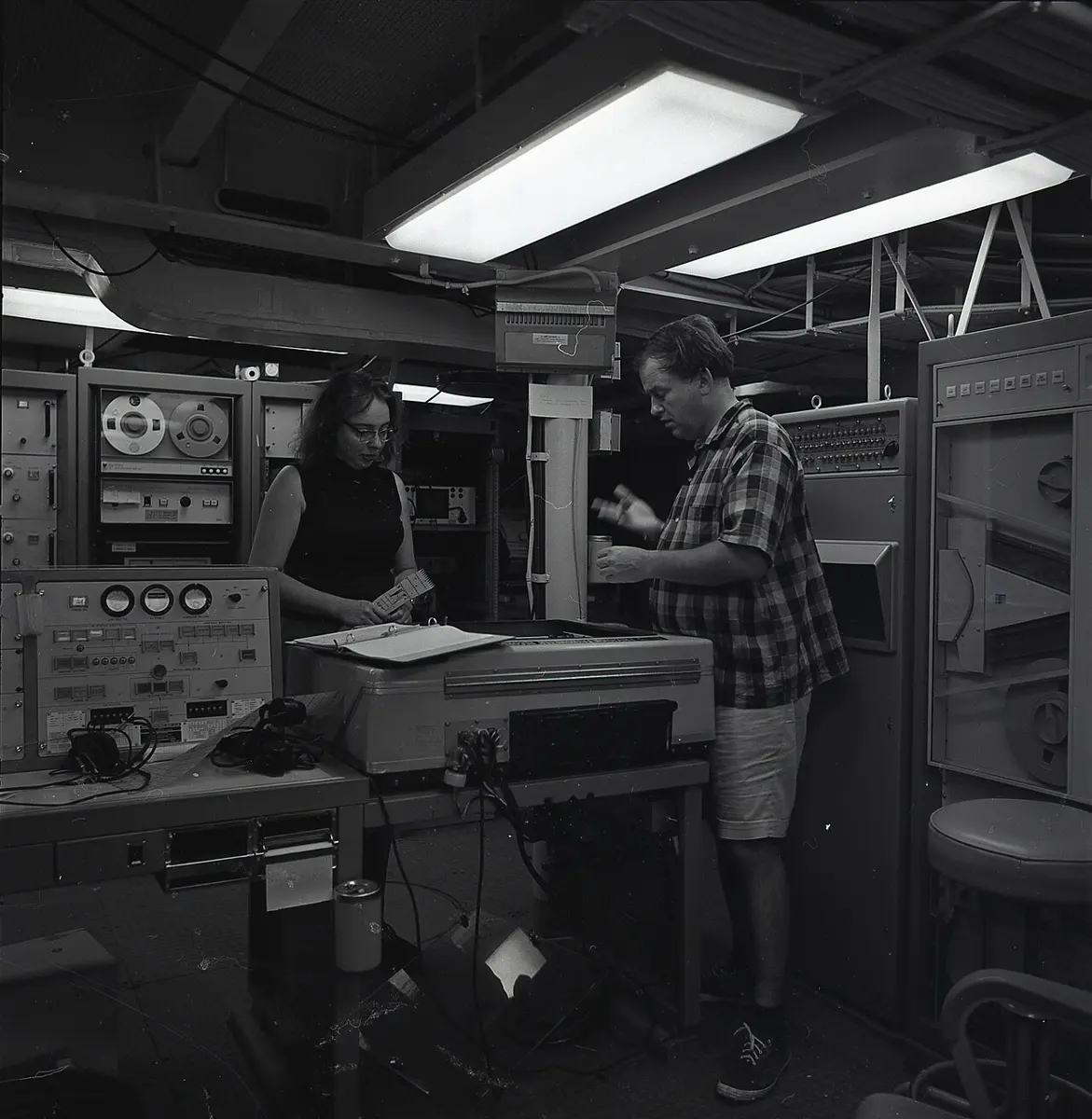
That is exactly what the ships found. In 1966 a profile across the Pacific–Antarctic Ridge, measured by the research ship Eltanin, was so perfectly symmetric that it could be folded down the middle and the two halves would match; and its pattern matched the reversal timetable from lava on land, stretched by the spreading speed. Sea-floor spreading had its proof.
The stripes do more than prove spreading: they measure its speed. Divide the width of a stripe by the time it took to make.
The magnetic stripes on one side of a ridge are a mirror image of the stripes on the other side. What does that tell you?
Pick an answer to see why.
Drilling for the proof
The magnetic stripes gave ages by matching patterns. Could anyone check them by bringing up the sea floor itself? In 1968 a new ship, the Glomar Challenger, began the Deep Sea Drilling Project. It could hold its place over water 6 km deep while it lowered a drill pipe, kilometers long, to the sea floor and drilled into it.
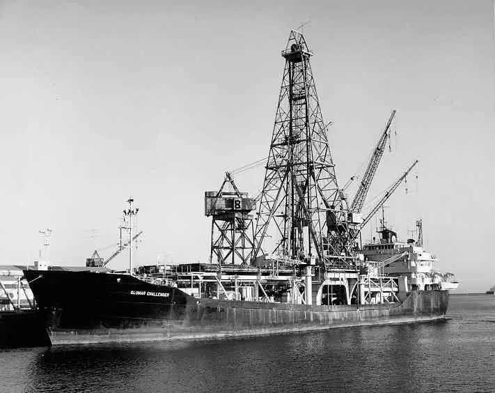
Mud settles on the sea floor all the time: dust blown from land, and the tiny shells of plankton that sink when they die. It can only settle on sea floor that already exists. So the oldest mud lying on the hard basalt rock tells you, roughly, when the basalt was made. Tiny fossils in the mud give its age, because different kinds of plankton lived at different times.
On its third voyage, from December 1968 to January 1969, the Glomar Challenger drilled a line of holes across the Mid-Atlantic Ridge in the South Atlantic, near 30° S. Here are the real results.
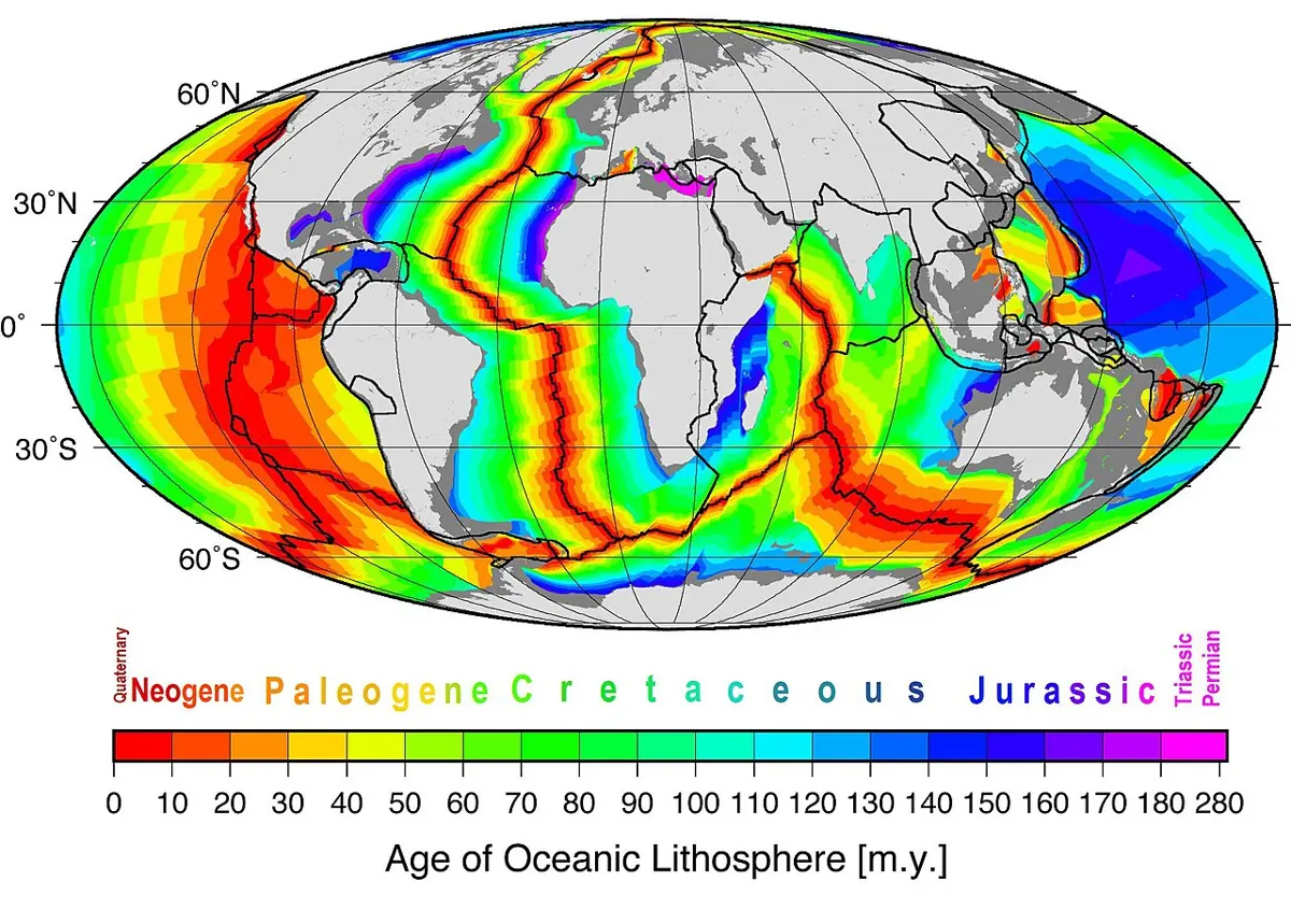
The ages rose steadily with distance from the ridge, on both sides, just as the magnetic stripes said they would, and gave the same speed: about 2 cm a year on each side. Since then, ships have drilled thousands of holes in every ocean. No sea floor has been found older than the stripes predict.
Why does the oldest mud at a drill site give the age of the sea floor beneath it?
Pick an answer to see why.
Why the sea floor dies young
The sea floor is not made only to stay. As a piece of it moves away from the ridge, it cools. Cool rock is denser, so the old sea floor sinks lower (that is why the sea is deeper far from the ridges, as in the echo-sounding try above), and the cold rock beneath it thickens the plate. After a few tens of millions of years, the plate of old sea floor is denser than the hot mantle under it. Where it meets another plate, it bends down and sinks into the mantle, making a deep trench. This sinking is called subduction.
So every piece of sea floor has a life: born at a ridge, carried across an ocean, and sunk at a trench, usually within 200 million years. Here is the whole sea floor, colored by age.
Old sea floor sinks at trenches, but continents don’t. Why?
Pick an answer to see why.
Why the continents keep their old rock
Because continents can’t sink, they keep almost all the rock they have ever had. And they grow. At a trench, volcanoes add new rock to the continent’s edge; islands, slivers of sea floor and small pieces of continent carried in on the sinking plate get scraped off and stuck on; and when two continents collide, their edges are crushed together into mountains. So a continent is usually oldest in the middle, at its core, and younger towards its edges, where pieces have been added on.
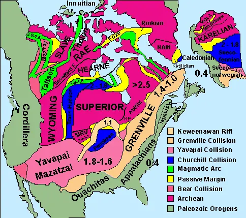
North America shows it clearly. Its core, around Hudson Bay, is rock over 2,500 million years old. Around it are belts 1,800–1,600 million years old, then belts 1,400–1,000 million years old, from collisions that welded new pieces on, then the Appalachian Mountains in the east, made in collisions about 300–450 million years ago, and the young mountains of the west, still being added to today.
India has old cores too: rocks over 3,000 million years old in the south and east of the country. The Himalaya are the reverse of what you might expect: very young mountains, still rising, made largely of old rock from India’s northern edge, some of it more than a billion years old, with the younger mud laid down in the Tethys Sea along India’s northern edge, shaligrams and all, piled on top.
Plates moving today
Stripes and drill holes show how the plates moved over millions of years. Are they moving now? Since the 1990s, GPS receivers fixed to rock all over the world have measured it directly. Like the GPS in a phone, but far more precise, they measure their position to within a few millimeters, and they all move, year after year, by a few centimeters, in the directions the stripes say. Iceland, which sits on the Mid-Atlantic Ridge, is being pulled apart by about 2 cm a year; Hawaii moves north-west by about 7 cm a year; and stations in Nepal show India still pushing into Asia (see Why Is Everest Still Rising?, Where plates meet).
There is another record of the past in the middle of the Pacific Plate. A hot plume of rock rises from deep in the mantle under Hawaii and makes volcanoes. The plate slides over it, carrying each volcano away, so the islands form a line, oldest farthest away.
Which pieces of evidence show plates moving today, not just in the past?
Pick an answer to see why.
Make a sea floor from paper
Questions
A ship crosses a mid-ocean ridge measuring the magnetic field. Which pattern does it find?
Pick an answer to see why.
Two drill sites are 200 km and 600 km from a ridge, on the same side. The first site’s rock is 10 million years old. If the spreading speed has stayed the same, how old is the rock at the second?
Pick an answer to see why.
Explain why some continental rocks are over 4,000 million years old, but no sea floor is much older than 200 million years.
Answer
Sea floor is made at mid-ocean ridges, carried away as the plates spread, and destroyed at trenches, where old, cold, dense sea floor sinks back into the mantle (subduction). Moving at a few centimeters a year across an ocean thousands of kilometers wide, a piece of sea floor usually reaches a trench within about 200 million years, and on average lasts about 100 million, so none survives to be very old. Continental rock is lighter (about 2.7 g/cm³, against about 3.0 g/cm³ for sea-floor rock) and floats too high to sink, so continents are not destroyed at trenches; they keep the rock they have had for billions of years, and grow at their edges.
Explain how the magnetic stripes on the sea floor are made, and why the pattern on one side of a ridge is a mirror image of the pattern on the other.
Answer
At the ridge, lava erupts and cools to make new sea floor. As it cools below a few hundred degrees Celsius, its magnetite grains become tiny magnets lined up with the Earth’s field at that moment, and the solid rock keeps that direction. The Earth’s field flips from normal to reversed and back at irregular times, so the rock made during each period is magnetized one way or the other, and adds to or subtracts from today’s field, which a magnetometer measures as strong or weak stripes. The new rock forms along the ridge’s center and then splits, half moving away on each side as the sea floor spreads, so each period leaves a stripe on both sides at the same distance from the ridge: a mirror image.
The table shows ages from drilling at three sites on one side of a ridge.
| Site | Distance from ridge (km) | Age of the oldest mud (million years) |
|---|---|---|
| A | 150 | 6 |
| B | 450 | 18 |
| C | 900 | 36 |
- a.Work out the spreading speed from each site, in cm a year.
- b.Is the speed steady? Explain.
- c.How far from the ridge would you expect to find mud 50 million years old?
Answer
- a.A: 150 ÷ 6 = 25 km per million years = 25 mm a year = 2.5 cm a year. B: 450 ÷ 18 = 25 km per million years = 2.5 cm a year. C: 900 ÷ 36 = 25 km per million years = 2.5 cm a year.
- b.Yes: every site gives the same speed, so the age is proportional to the distance, and the sea floor has moved away at a steady 2.5 cm a year for at least 36 million years.
- c.Distance = speed × time = 25 km per million years × 50 million years = 1,250 km.
Wegener’s continental drift was rejected in the 1920s, but sea-floor spreading was accepted in the 1960s. What new evidence made the difference? Give at least three pieces, and say what each shows.
Answer
- The shape of the sea floor (echo sounding): mid-ocean ridges with rift valleys along their crests, where the crust is being pulled apart, and deep trenches. This gave a mechanism: continents don’t plow through the sea floor; they ride on plates that are made at ridges and sink at trenches.
- Magnetic stripes, parallel to the ridges and mirror images on the two sides, matching the timetable of the field’s flips worked out from dated lava on land. They show that sea floor was made at the ridges at known times and carried away on both sides, at speeds that can be measured.
- Drilling: the oldest mud on the sea floor gets steadily older with distance from the ridge, on both sides, giving the same spreading speeds as the stripes.
- Earthquakes: shallow ones along the ridges, and ones going deep into the mantle under trenches, tracing the sinking slabs of sea floor.
Later, GPS measured the plates moving today, at the predicted speeds.
A classmate says: “The sea floor is young because the oceans only formed about 200 million years ago. Before that, the Earth had no oceans.” Evaluate this claim, using evidence.
Answer
The claim doesn’t fit the evidence. Rocks on the continents that formed in water show that there have been oceans for billions of years: pillow lavas, which form only when lava erupts under water, are found in Greenland in rocks about 3,800 million years old, and there are marine fossils, like the shaligram ammonites, from many periods. Pieces of old sea floor (ophiolites) are found pushed up on land, and the eastern Mediterranean may hold sea floor 340 million years old. And today’s sea floor is not all the same age, as it would be if all oceans had formed at once: it is youngest at the ridges and older with distance from them, in mirror-image bands. The better explanation is that the oceans are old, but their floors are continually made at ridges and destroyed at trenches, so the floor under any ocean today is young.
The Atlantic Ocean is getting wider by a few centimeters a year. The Earth is not getting bigger. What must be happening somewhere else? Where?
Answer
If one ocean gets wider and the Earth stays the same size, sea floor must be destroyed somewhere else as fast as the total being made. It sinks at the trenches, mostly around the Pacific Ocean (along South America, Japan, the Mariana Islands, Indonesia), so the Pacific is slowly getting smaller while the Atlantic grows.
Where to go next
- Why Is Everest Still Rising? The heat inside the Earth that drives the plates, how we know what the inside is like, and what happens where plates meet, as India pushes into Asia.
- How Old Is the Earth? How the radioactive clocks in rocks, meteorites and tiny zircon crystals give their ages, and what the oldest rocks tell us about the young Earth.
- How Do Magnets Push Without Touching? Magnetic fields, the invisible pattern the sea floor records.