
Most of India’s coal is dug from mines in Odisha, Chhattisgarh and Jharkhand. In the gray shale between the layers of coal you can often find the print of a leaf: long, shaped like a tongue, with a strong line down the middle. It belonged to a plant called Glossopteris, which grew in forests about 300 to 250 million years ago.
In 1912 the British explorer Robert Falcon Scott and his men reached the South Pole, and on their way back, starving and freezing, they kept dragging about 16 kg of rocks on their sledge. Their bodies were found later that year, with the rocks still beside them. In the rocks were the same tongue-shaped leaves.
Glossopteris is found in India, in Africa, in South America, in Australia, and in Antarctica, where nothing like a forest grows today. These lands are now thousands of kilometers apart, across oceans. A plant can’t walk. So how did the same plant get to all of them? This topic follows the clues that answer it: the shapes of the continents, the fossils and rocks on them, and the shape of the sea floor between them.
A jigsaw puzzle on the map
Look at a map of the Atlantic Ocean. The bulge of Brazil looks as if it would fit into the curve of Africa’s west coast, like two pieces of a jigsaw puzzle. People noticed this as soon as there were good maps of both coasts, in the 1500s and 1600s. But a fit could be chance. To show the continents were once joined, you need more than shapes.
The coast is not the edge
A coastline is not really where a continent ends. Around most continents the land carries on under the sea, as a shallow platform called the continental shelf, usually less than 200 m deep. At its outer edge the sea floor drops steeply, down the continental slope, to the deep ocean floor 4 or 5 km down. The true edge of a continent is the bottom of that slope, not the beach. Where the sea level is today is an accident: during the last Ice Age, 20,000 years ago, the sea was about 120 m lower and much of the shelf was dry land.
So the fair test is to fit the continents along the edges of their shelves. In 1965 the British geophysicist Edward Bullard and two colleagues did it on a computer, an early use of computers in geology. They fitted the edges where the sea is about 900 m deep (500 fathoms, as their charts measured it), halfway down the slope. Try it.
Along the edges of the shelves, the fit is astonishing: over thousands of kilometers of coast, the gaps and overlaps are mostly less than 100 km. A few pieces don’t fit, and they are the exceptions that prove the rule. The biggest overlap is the delta of the River Niger in Nigeria, which the river built out into the sea after the Atlantic opened, from mud it carried down. Pieces of land added later shouldn’t fit, and they don’t.
Why does the fit of South America and Africa work better along the edges of their continental shelves than along their coastlines?
Pick an answer to see why.
Fossils that couldn’t have crossed
A shape that fits is a clue. Fossils are a stronger one, because living things don’t cross oceans easily.
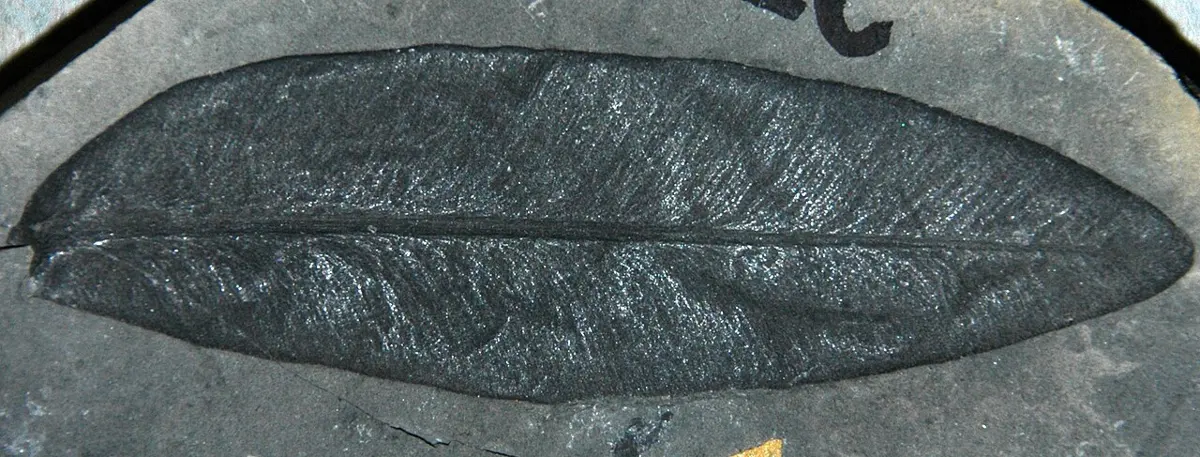
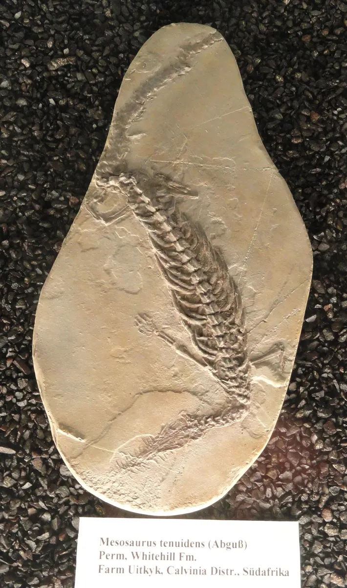
Here are four of the living things whose fossils Wegener and others used. All four lived late in the Paleozoic era or early in the Mesozoic, from about 300 to 235 million years ago (you met the eras in Grade 8: The geological time scale).
| Fossil | What it was | Found in |
|---|---|---|
| Glossopteris | a seed plant, trees and shrubs; most of India’s coal is made from its forests | India, Africa, South America, Australia, Antarctica |
| Mesosaurus | a slim reptile about 1 m long, that swam in a shallow inland sea | southern Brazil and Uruguay; Namibia and South Africa |
| Lystrosaurus | a plant-eating animal about the size of a pig, with two short tusks | South Africa, India, Antarctica (and China and Russia) |
| Cynognathus | a meat-eater about the size of a large dog | Argentina, South Africa, Antarctica |
None of them could have crossed an ocean. Mesosaurus and Lystrosaurus were land and shallow-water animals, and Mesosaurus is found only in rocks laid down in one shallow sea, on two coasts that are now 6,000 km apart: not in North America, not in Europe, not anywhere in between. Glossopteris seeds were not the kind that wind or birds carry across thousands of kilometers of ocean, and the plant is not found on the northern continents at all. And it isn’t just one fossil turning up in two places: whole sets of plants and animals match, layer after layer.
Now put the fossils on a map of the continents fitted together. Each one’s area runs across the joins, as if the continents had been torn apart after the animals and plants lived.
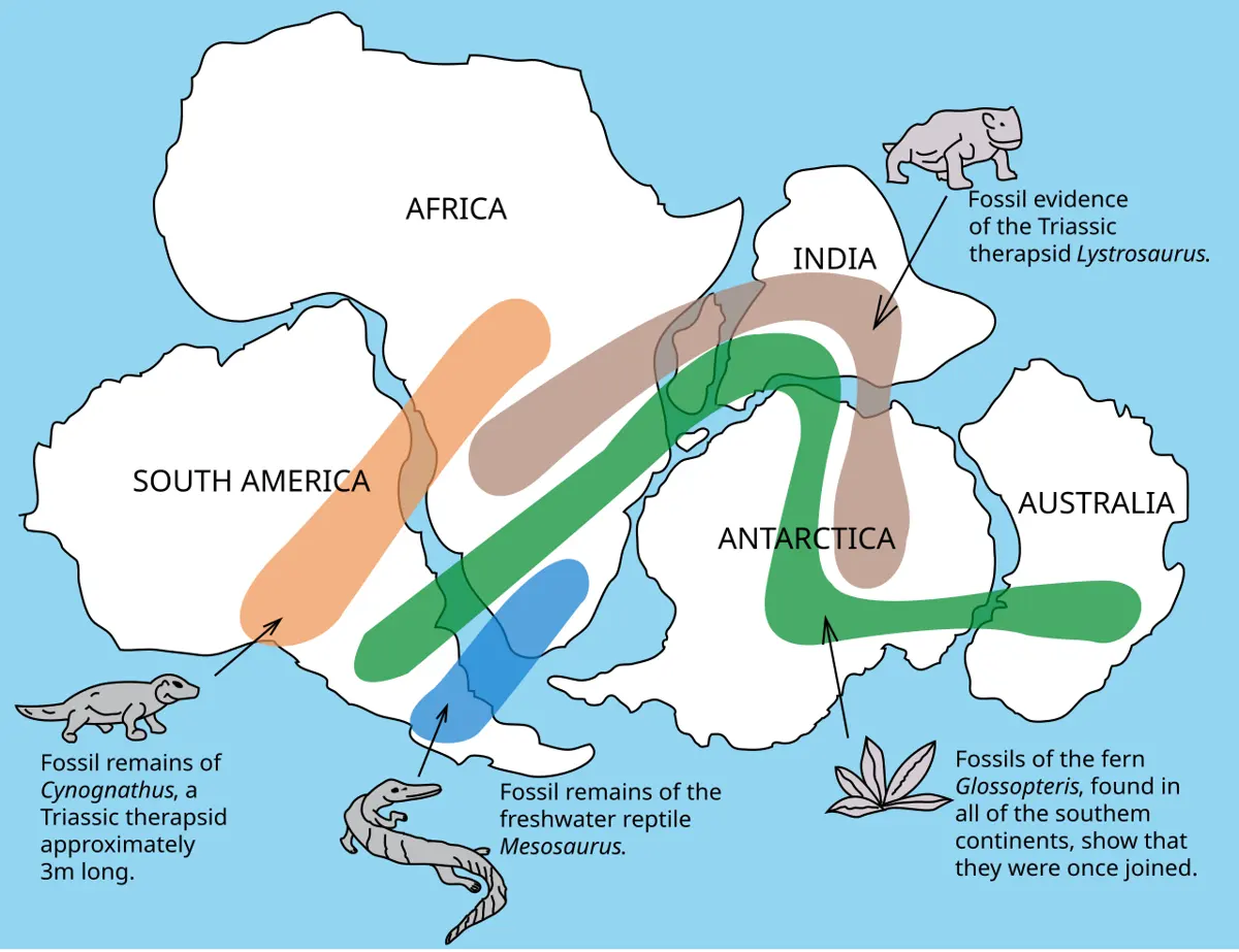
This great southern land is called Gondwana, after the Gond region of central India, where its rocks, coal and fossils were first studied, in the 1870s. India was part of it. Glossopteris is found just over Nepal’s eastern border, in the hills of Darjeeling and Sikkim.
Mesosaurus fossils are found in southern Africa and in South America, and nowhere else. What is the best explanation?
Pick an answer to see why.
Rocks and mountains that match
Wegener compared it to a torn newspaper. If you tear a page in two, you can show the pieces belong together by fitting their edges. But if the lines of print also run straight on from one piece to the other, you can be sure.
The lines of print are the rocks. Different parts of a continent are made of rocks of different kinds and ages, in belts. If two continents were joined, the belts should run across the join.
Mountains match too. The old, folded mountains along the south of South Africa, the Cape Fold Belt, have a twin in Argentina, south of Buenos Aires: the Sierra de la Ventana, made of the same kinds of rock, folded the same way, at the same time, about 280–250 million years ago. Fit the continents together and the two ranges line up. In the north, the Appalachian Mountains of North America line up in the same way with the mountains of Scotland and Norway.
Ice in the tropics
The strangest clue is ice. About 300 million years ago, great ice sheets scraped across parts of South America, Africa, Antarctica, Australia and India. Where ice slides over rock, stones frozen into its bottom scratch long, straight grooves, and when it melts it leaves a jumble of clay and boulders.
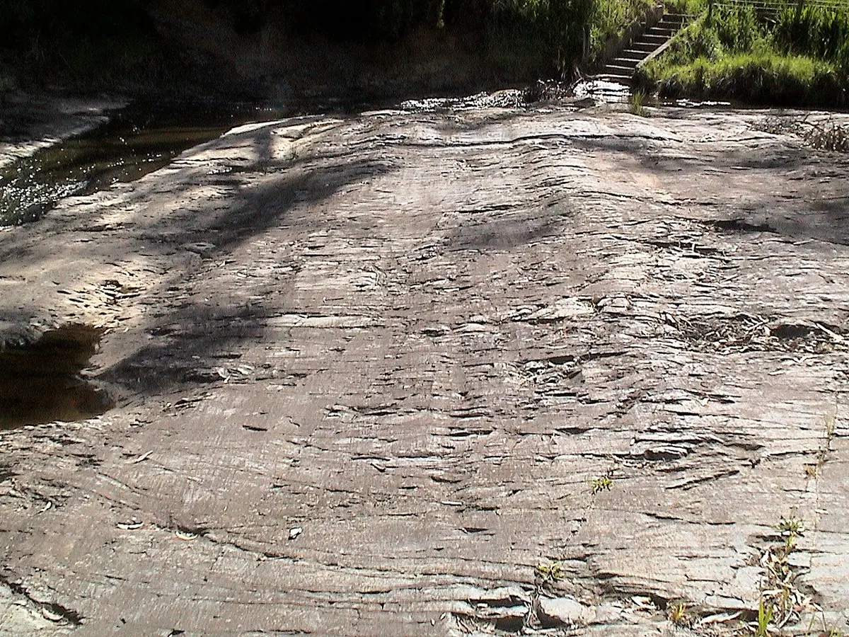
Rocks like these are found in central India and in southern Africa, where it is hot today. And when the continents are put back together as Gondwana, the grooves on all of them point away from one region, as if one great ice sheet had spread out from a center, near where the South Pole was then. Coal from forests in Antarctica, and ice scratches in India: neither makes sense with the continents where they are now. Both make sense if the continents have moved.
Rocks scratched by ice sheets 300 million years ago are found in India, which is now near the equator. Which explanation fits all the evidence best?
Pick an answer to see why.
The shape of the sea floor
Wegener’s clues showed that the continents had been joined. They didn’t show how they moved. That evidence was under the sea, and nobody could see it.
Until the 1920s the depth of the deep sea was measured by lowering a weighted rope until it touched the bottom: hours for a single measurement. Then ships began to use echo sounding: send a short pulse of sound down from the ship and time its echo from the sea floor. Sound travels through sea water at about 1,500 m/s.
By the 1950s, ships had crossed every ocean with their echo sounders running. Now it is your turn.
The sea floor is nothing like the flat, muddy plain people had imagined. Along both lines you found:
- Continental shelves and slopes at the edges of the continents, as in the jigsaw fit.
- Deep plains, flat and roughly 4 to 6 km deep, covered in mud.
- A mid-ocean ridge: a long range of underwater mountains, 1 to 3 km higher than the plains on either side (gentle and broad in the Pacific, steeper and more rugged in the Atlantic). In the Atlantic it runs down the middle, the same distance from both coasts and the same shape as them. Along its crest runs a deep crack, a rift valley. The ridges of all the oceans join into one chain about 65,000 km long, the longest mountain range on Earth, nearly all of it under the sea.
- In the Pacific, a trench: a long, narrow trough, much deeper than the plains, right beside a coast lined with mountains and volcanoes, the Andes. The deepest place in the oceans, the Challenger Deep in the Mariana Trench, is nearly 11 km down: Sagarmatha would fit inside with more than 2 km of water above its top.
On a map, the ridges are also cut across, every few tens or hundreds of kilometers, by straight cracks called fracture zones, where one stretch of the ridge is shifted sideways from the next, like the steps of a staircase.
Where is the Mid-Atlantic Ridge?
Pick an answer to see why.
Plates
A ridge in the middle of an ocean, the same shape as the coasts; trenches by the mountains; continents that fit. In 1962 the American geologist Harry Hess put the clues together, and in the late 1960s the whole idea was worked out. It is called plate tectonics (from the Greek tekton, a builder).
The Earth’s outer shell is not one piece. It is broken into about a dozen large pieces, and many smaller ones, called plates. A plate is about 100 km thick: the crust and the cold, stiff top of the mantle below it. The plates rest on hotter mantle rock that, over millions of years, can flow very slowly, like very stiff toffee. And the plates move, a few centimeters a year, carrying the continents and the sea floor with them. A continent doesn’t plow through the sea floor, as Wegener thought: it rides on a plate, like a passenger.
Where are the plates’ edges? Plates moving against each other make earthquakes, so the earthquakes show you.
Most of the Earth hardly ever shakes. Nearly all earthquakes happen along narrow lines, and the lines are the ridges, the trenches and the young mountain ranges you found on the sea floor and the continents. The lines join up into closed shapes: the plates. What happens at a plate’s edge depends on how the two plates move:
- Moving apart, at a mid-ocean ridge. Hot rock from the mantle rises into the gap, part of it melts, and the melt erupts as lava along the rift valley and cools into new sea floor. As the plates keep moving, the new rock is carried away on both sides, and more fills the gap. The sea floor is made here, like two conveyor belts running away from each other.
- Moving together. Where a plate of sea floor meets another plate, the old, cold, heavy sea floor bends down and sinks back into the mantle under it, making a trench. The sinking plate is followed down by earthquakes, and melting above it feeds a line of volcanoes, like the Andes. Where two continents meet, neither sinks back into the mantle, because continental rock is too light: they crumple and pile up into high mountains. That is happening in Nepal.
- Sliding past each other, along faults like the fracture zones, with earthquakes but no new or sunken sea floor.
So the Atlantic is growing. South America and Africa are on two different plates, moving apart from the Mid-Atlantic Ridge between them, and every year a little new sea floor is added along it. If that is true, the sea floor should be youngest at the ridge and older and older towards the continents. In 1968–69 the drilling ship Glomar Challenger drilled into the sea floor across the South Atlantic, near 30° S, and found exactly that: the oldest mud lying on the rock was 11 million years old 191 km from the ridge, and 67 million years old 1,270 km to the west. You can drill it yourself in Why Is the Sea Floor So Young? (Drilling for the proof), in Going Further 9–12.
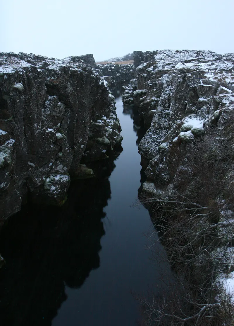
On the earthquake map, why is there a line of earthquakes down the middle of the Atlantic, but hardly any along its coasts?
Pick an answer to see why.
How fast?
Plates move about as fast as your fingernails grow: a few centimeters a year. That sounds like nothing. But the Earth has had a very long time.
To work out speeds over millions of years, a trick saves a lot of zeros. One kilometer is 1,000,000 mm, so 1 km per million years = 1 mm per year.
Today plates are measured directly, by GPS: the same satellites your phone uses, but with receivers fixed to solid rock that measure their position to within a few millimeters, day after day, for years. You met this use of GPS in Grade 9 Grade 9: Global Positioning System. The fastest plates move more than 10 cm a year; the slowest, a few millimeters.
Nepal on the move
Put the clues together and you can follow India’s journey. About 300 million years ago it was part of Gondwana, far in the south, next to Africa, Madagascar and Antarctica, with ice sheets scraping its rocks and, later, Glossopteris forests growing in its swamps. Gondwana began to break up about 180 million years ago. India broke away and moved north across what became the Indian Ocean, for a time at up to about 15 cm a year, one of the fastest journeys of any continent we know of. Ahead of it lay an ocean, the Tethys, whose sea floor sank under Asia.
About 50 million years ago India reached Asia. A continent can’t sink back into the mantle, so the edges of the two crumpled and piled up, and the Himalaya began to rise, carrying up the layers of mud and lime laid down in the seas along India’s northern edge. That is why the shaligrams that pilgrims find along the Kali Gandaki are fossil sea animals, ammonites, and why the rock at the top of Sagarmatha is limestone made on the floor of a warm, shallow sea more than 440 million years ago, with broken bits of sea lilies in it.
So most of the rock of Nepal was once part of India. As India slides north under Tibet, along a great fault called the Main Himalayan Thrust, slices of its crust are scraped off its top and stacked up, one over another, into the hills and the high Himalaya. The Terai lies on the Indian Plate itself, south of where that fault reaches the surface.
It hasn’t stopped. GPS stations across Nepal show India still pushing north, and about 2 cm a year of that push squeezes Nepal itself: southern Nepal is moving closer to Tibet, year by year. The rocks can’t squeeze for ever. The strain builds up, until a fault deep under the hills slips in a few seconds. On 25 April 2015, in the Gorkha earthquake, GPS stations in Kathmandu jumped about 2 m to the south and rose by more than 1 m.
Try it yourself
Questions
Which of these is not evidence that the continents were once joined?
Pick an answer to see why.
A geologist finds a line of earthquakes and a deep trench running along a coast, with a chain of volcanoes on the land beside it. What is happening there?
Pick an answer to see why.
A student says, “Africa and South America look as if they fit, but that could just be chance.” What other evidence would you show the student, and why is it stronger than the shapes alone?
Answer
The shapes could be chance, but they fit much better along the edges of the continental shelves, which are the real edges of the continents. Stronger evidence is what lies on the continents: the same fossils (Mesosaurus in Brazil and South Africa, Glossopteris on all the southern continents), rocks of the same ages that line up across the join (old rock at São Luís in Brazil matching old rock in Ghana, as Hurley predicted before measuring), and mountain ranges that line up (the Sierra de la Ventana and the Cape Fold Belt). It is very unlikely that shapes, fossils, rock belts and mountains would all match by chance, like a torn newspaper whose edges fit and whose lines of print also run straight across the tear.
Here are some fossils and where they are found today.
| Fossil | Age (million years) | Found in |
|---|---|---|
| A | 270 | South America, Africa |
| B | 250 | Africa, India, Antarctica |
| C | 30 | South America only |
| D | 30 | Africa only |
- a.Which fossils show that the continents were joined? Explain.
- b.What do C and D suggest about South America and Africa 30 million years ago?
Answer
- a.A and B: each is found on continents now separated by oceans, which these plants or animals could not have crossed, so those continents must have been joined 270 and 250 million years ago.
- b.C and D are of the same age but each is found on only one of the two continents. So by 30 million years ago the animals of South America and Africa were living apart: the two continents had already been separated by the Atlantic, and their living things were evolving separately. (This fits the age of the South Atlantic’s oldest sea floor, about 130 million years.)
A ship crosses an ocean timing echoes. Here are four of its readings.
| Place | Echo time (s) |
|---|---|
| P | 0.2 |
| Q | 6.0 |
| R | 3.2 |
| S | 10.0 |
- a.Work out the depth at each place (sound in sea water: 1,500 m/s).
- b.Which place is most likely over a continental shelf, a deep plain, a mid-ocean ridge and a trench?
Answer
- a.Depth = 1,500 × time ÷ 2. P: 150 m. Q: 4,500 m. R: 2,400 m. S: 7,500 m.
- b.P (150 m) is the continental shelf; Q (4,500 m) a deep plain; R (2,400 m), much shallower than the plain far from land, a mid-ocean ridge; S (7,500 m), much deeper than the plains, a trench.
The drilling ship Glomar Challenger drilled at several places on both sides of the Mid-Atlantic Ridge in the South Atlantic in 1968–69. Here are four of its sites west of the ridge, with the age of the oldest mud on the sea-floor rock at each.
| Distance from the ridge (km) | Age (million years) |
|---|---|
| 191 | 11 |
| 380 | 24 |
| 727 | 40 |
| 1,270 | 67 |
- a.What pattern do you see?
- b.Use the farthest site to work out the average speed at which the sea floor has moved away from the ridge, in cm a year.
- c.How does this support the idea of plates moving apart at the ridge?
Answer
- a.The farther from the ridge, the older the sea floor; the age goes up steadily with distance (roughly in proportion to it).
- b.Speed = 1,270 km ÷ 67 million years = 19 km per million years = 19 mm a year ≈ 1.9 cm a year.
- c.If new sea floor is made at the ridge and carried away steadily, the rock near the ridge must be young, and the farther it has traveled, the older it must be, which is what the drill found. (Sites east of the ridge show the same pattern, on the African Plate moving the other way.)
Rocks with marks of ice sheets 300 million years old are found in India. Coal, made from forests, of about the same age is found in Antarctica. Explain how both can be true.
Answer
Both continents were then parts of Gondwana, in different places from where they are now. India was far south, near the South Pole of the time, so it was covered by an ice sheet. Later, after the ice melted, Glossopteris forests grew in the swamps of Gondwana, Antarctica included, and made coal (the Earth’s climate was also warmer then, so forests could grow at high latitudes). Since then the plates have carried India north towards the equator and Antarctica to the South Pole, where it is too cold for forests today.
India is moving towards the rest of Asia at about 4 cm a year. India met Asia about 50 million years ago. If it had moved at today’s speed all that time, how far would it have pushed into Asia since then? What has happened to all that rock?
Answer
4 cm a year = 40 km per million years, so in 50 million years: 40 × 50 = 2,000 km. Continental rock is too light to sink, so it has been crumpled and stacked up into the Himalaya and the Tibetan Plateau, the highest and thickest piece of continent on Earth, and some has been squeezed out sideways, to the east. (India was moving faster before it met Asia; the collision slowed it down.)
Where to go next
- How Does One Rock Become Another? Plates make mountains and sink sea floor into the mantle: how the rocks of the Earth are melted, squeezed, worn away and made again.
- How Do Rocks Tell Time? How the layers of rock and the fossils in them give the order of the Earth’s history.
- Why Is the Sea Floor So Young? In Going Further 9–12: magnetic stripes on the sea floor, the drill holes, and why no sea floor is older than about 200 million years.