
Within about a minute on 25 April 2015, the Kathmandu Valley rose by a meter. Satellites that had measured the ground before the earthquake measured it again afterward, and the whole basin, with its cities, temples and fields, was about 1 m higher than it had been. Farther north, the high Himalaya had gone the other way. They had dropped by about 60 centimeters.
That is not what most people picture when they think of an earthquake. They picture shaking, and the shaking was real: it began at four minutes to noon, it went on for about fifty seconds, and nearly 9,000 people in Nepal died in it and in the large aftershock that followed on 12 May. About half a million houses were destroyed. But the meter is the clue to what happened underneath, and once you see it, the shaking makes sense too.
Stuck, then sudden
The best way into it is through California. On 18 April 1906 a great earthquake and the fires after it wrecked San Francisco, and afterward an American scientist named Harry Fielding Reid studied how the ground had moved along the San Andreas Fault. He concluded that the rock on either side had been slowly bending for years before, and that in the earthquake it had sprung back.
His explanation is still the one geologists use. The two sides of a fault keep moving, a few centimeters a year, carried by their plates. But the fault itself is stuck, held by friction where the rocks press together. So the rock near it bends instead, the way a ruler bends when you hold one end and push the other. Year after year the bending stores more strain. Then one day the strain is more than the stuck patch can hold, the fault slips by meters in a few seconds, and the bent rock snaps back toward its old shape. Reid called it elastic rebound. The jolt of that snap, spreading out through the rock in waves, is the earthquake. GPS measurements since have shown him to be largely right.
Nepal has the same thing, on a bigger scale and lying almost flat. India is still moving north into Asia, and where the plates meet under Nepal the fault between them, the Main Himalayan Thrust, slopes gently down to the north at about 10 degrees. India slides under it. The fault comes up to the surface at the southern foot of the Chure hills, and from there to beneath the high mountains, nearly 100 kilometers, it is locked. Deeper and farther north, under Tibet, the rock is hot enough to creep, and the two sides slide past each other quietly. Across the Himalaya India gains on Tibet by about 2 centimeters a year, and on the locked part of the fault none of that is slipping. It is being stored, as bending in the rock above.
That bending is what squeezes the mountains up, slowly, between earthquakes. In an earthquake it is let go. The land above the part of the fault that slipped jumps up and southward, and the land just north of it, which had been bent upward, settles back. That is the Kathmandu Valley’s meter and the high Himalaya’s 60 centimeters. So the great peaks seem to rise in the quiet years between earthquakes and drop a little in each one. Scientists are still working out how the two add up over thousands of years, but the rising wins: the range is still growing.
The slip in 2015 started under Barpak in Gorkha, on the deep edge of the locked part of the fault. It didn’t stay there. It ran east along that edge for about 140 kilometers, at about 3 kilometers a second, passing under Kathmandu as it went. On 12 May a magnitude 7.3 earthquake carried it farther east. The place where the slip began underground is called the focus, or hypocenter, उद्गमविन्दु in Nepali, and the point on the ground straight above it is the epicenter, केन्द्रविन्दु. The epicenter in 2015 was near Barpak, but the damage followed the whole length of the slip.
A slipping fault sends out several kinds of wave. The first to arrive pushes and pulls the rock along the way it travels, and it does little harm. Behind it comes a slower wave that shakes the ground from side to side. These two go through the whole planet, which is how seismologists can see inside it. Last come two kinds of wave that travel along the surface itself, one swaying it from side to side and one rolling it like the sea, and because they move the ground farthest they do most of the damage.
How big?
Every earthquake gets two kinds of number, and they measure different things.
Magnitude is the size of the earthquake itself, at its source, and each earthquake has one. The scale was first worked out in 1935 by Charles Richter in California, from how far the needle of a seismograph swung. Each step up the scale means a swing ten times as large, and about 32 times as much energy let go. So a magnitude 8 isn’t a little bigger than a 7. It is about thirty-two 7s. Richter’s scale works well for small earthquakes but gives up on great ones: past a certain size it can’t tell them apart. Seismologists now use the moment magnitude, worked out from how large an area of fault slipped and how far, which keeps on counting however big an earthquake gets. That is why one earthquake can be given slightly different magnitudes. For 2015 the US Geological Survey gives 7.8, the Global CMT project, which works it out from the whole of the waves, 7.9, and a Nepal government slide from 2016 calls it “7.6 Richter Scale”. They are measuring with different rulers. Why Is a Magnitude 8 Earthquake Not Just a Bit Bigger Than a 7? does the sums.
Intensity is what an earthquake does at one place, and it is different everywhere. It is written in Roman numerals, from I, felt by almost nobody, up to XII, everything destroyed, judged by what people felt and what broke. In 2015 the US Geological Survey put the shaking at VIII in Kathmandu and Kirtipur, VII in Bhaktapur, Lalitpur and Pokhara, and IV as far away as Dhaka.
Distance is the main thing that sets intensity, but not the only one. The direction the fault tore matters, and so does the ground. Bedrock shakes least and soft mud most, and the Kathmandu Valley is the bed of an old lake, filled with soft sediment. In 2015 that fill swayed back and forth slowly, and the slip under the city had passed as a smooth pulse rather than a hard jolt. That spared many of the valley’s ordinary low houses, while some of its taller buildings, which sway slowly themselves, were badly hit. Why the valley is a lake bed is a story for a later chapter.
Why Nepal has no volcanoes
Earthquakes happen at nearly every kind of plate edge. Volcanoes don’t, and the reason is how rock melts.
The mantle under the plates is hot enough to melt, and yet almost all of it is solid, because the weight of everything above presses it. Rock that is that hot can melt in three ways: it gets hotter still, the pressure on it drops, or something is mixed into it that lowers its melting point. Water does that very well.
Where two plates pull apart, hot mantle rises into the gap. As it rises, the pressure on it drops, and some of it melts. That is how new sea floor is made all along the ridges in the middle of the oceans, and in Iceland, where the ridge comes up above the sea, it makes a country full of volcanoes.
Where ocean floor sinks under another plate, it carries water down with it, locked inside its minerals. Deep down, heat and pressure break those minerals apart, the water is squeezed out into the hot mantle above, and the mantle melts. The melt is lighter than the rock around it, so it rises, and it comes out as a line of volcanoes above the sinking plate. That is Japan, and the Andes, and most of the volcanoes around the Pacific, the ring of edges called the Ring of Fire. About four in five of the world’s largest earthquakes happen along it too.
Then there are hot spots, places where unusually hot rock rises from deep in the mantle wherever the plate above it happens to be. Hawaii sits on one, in the middle of the Pacific plate, nowhere near an edge.
Nepal has none of these. Here a continent meets a continent. Both are made of rock too light to sink far into the mantle, so neither goes down the way ocean floor does, and no wet slab sinks beneath us to set the mantle melting. The crust crumples and stacks instead, and slips in earthquakes, but no melt comes up. Across southern Tibet, behind the Himalaya, there isn’t one active volcano.
It wasn’t always like this. Before India arrived, the floor of the Tethys Ocean was sinking under the southern edge of Asia, and that edge had what the Andes have now: a long line of volcanoes, in what is today southern Tibet. Geologists call what is left of it the Gangdese arc. It was busy, on and off, for tens of millions of years, and it died away after India arrived and the last of the ocean floor between them was gone. Its granite roots are still there, north of the Himalaya. When the ocean ran out, so did the volcanoes. The earthquakes stayed.
Japan and Iceland
Two other countries show the other kinds of edge, and each has something to teach Nepal.
Japan sits where the floor of the Pacific sinks under the plate that carries northern Japan, about 8 centimeters a year, four times faster than India moves into Tibet. So Japan has both. It counts 111 active volcanoes, close to a tenth of the world’s, Mount Fuji the most famous of them, a tall, steep cone. And on 11 March 2011 the fault off its northeast coast slipped in an earthquake of magnitude 9.0 or 9.1. A piece of fault about 400 kilometers long and 150 wide moved, in places by 50 meters or more. Because the fault lay under the sea, the slip heaved up the sea floor and the ocean above it. The tsunami that followed ran up the land to nearly 40 meters above the sea. Japan’s Fire and Disaster Management Agency counted 19,759 dead and 2,553 missing in 2022, a count that takes in those who died later of the hardship. Of the bodies the police had examined a year after the earthquake, nine in ten had drowned. In Nepal the houses killed people. In Japan, mostly, the sea did.
Japan also shows what can and can’t be done about warning. Its seismometers caught the first, fast, harmless waves, and 8.6 seconds later the Japan Meteorological Agency sent out a warning, which reached places in Miyagi, nearest the fault, before the strong shaking did. But in those first seconds the earthquake looked far smaller than it was, so the warning went only to the northeast, and Tokyo, which shook hard, got none. That isn’t prediction. The earthquake had already begun, and the warning only outran its slower waves. Close to where a fault breaks, there may be no time at all. Nobody, anywhere, has ever predicted a major earthquake, saying when, where and how big, and the US Geological Survey says plainly that it doesn’t expect anyone to be able to any time soon.
Iceland is the opposite of Nepal. It sits on the Mid-Atlantic Ridge, the seam of underwater mountains that runs down the middle of the Atlantic, at one of the few places it rises above the sea, and the North American and Eurasian plates are pulling it apart at about 1.8 to 1.9 centimeters a year. That is close to the speed at which India and Tibet are pushing together under Nepal. Same speed, opposite direction, and a completely different country. At Þingvellir (Thingvellir), the pulling has opened cracks in the ground you can walk along, one of them a small canyon.
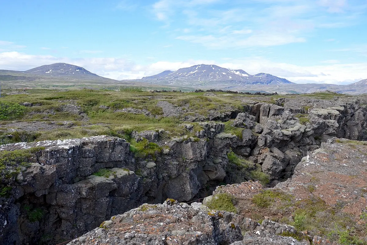
The lava that comes up at a ridge is mostly runny basalt, which pours out in floods rather than blowing up. That doesn’t make it harmless. In 1783 the Laki fissure in southern Iceland began an eruption that lasted eight months. It poured out nearly 15 cubic kilometers of lava and clouds of poisonous gas that killed more than half of Iceland’s farm animals, and in the famine that followed about a fifth of its people died.
Volcanoes over sinking plates tend to be the other kind. Their magma is richer in silica, the stuff of glass and sand, and it is stiff and sticky. Gas dissolved in it can’t bubble out gently, so it builds up until the magma bursts apart. That is how Vesuvius buried Pompeii in the year 79, killing more than a thousand people, and how Mount St. Helens in the United States blew out its whole north side in 1980. The shape of a volcano follows its lava. Runny lava spreads far and builds broad, gentle mountains, called shield volcanoes, like those of Hawaii. Layer upon layer of sticky lava and ash builds steep cones, like Fuji. A big eruption can empty the chamber beneath a volcano so that its top falls in, leaving a wide basin called a caldera, and rain can fill a crater or caldera to make a lake.
Iceland also shows why the old words for volcanoes, active, dormant and extinct, are rougher than they sound. The Reykjanes peninsula in the southwest had not erupted for some 800 years when, in 2020, the ground began to rise, then to shake, and from 2021 to erupt. In November 2023 the fishing town of Grindavík was emptied overnight as the earthquakes grew, and on 14 January 2024 lava flowed into the town and burned at least three houses. A volcano that has been quiet for a long time can still wake, which is why the US Geological Survey counts volcanoes as active or potentially active.
And yet Icelanders live on top of all this comfortably. The heat that makes the volcanoes also heats underground water, and most of Iceland’s homes are heated by it. Nepal’s edge gives it the danger without the heating.
What makes a building stand
Engineers have a saying: earthquakes don’t kill people, buildings do. The ground shaking seldom hurts anyone directly. The danger is what falls.
When the ground jerks sideways, the base of a house goes with it, but its heavy walls and roof are left behind for a moment, so the walls bend. Stones laid in mud hold up their own weight for centuries, pressed together from above, but they can hardly resist being pulled apart, so a long wall shaken sideways splits at the corners, where it only touches its neighbors, and falls outward. Then the roof falls in. That is how most of the houses fell in the hill villages in 2015.
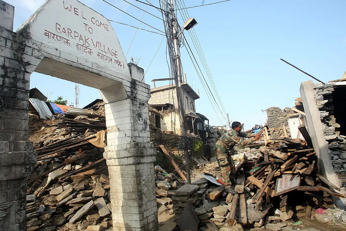
So a building that stands is, first of all, one that holds together. Its walls are tied into one box, with bands of reinforced concrete or timber running around them like the hoops of a barrel, so that a wall pushed sideways is held up by the walls at its ends. Its roof is light and fastened down. Its shape is simple and even, so that it doesn’t twist. And it suits its ground: on soft ground, buildings that sway at the same pace as the ground get shaken hardest. Can You Design an Earthquake-Safe House? takes the engineering further, with the houses Nepal rebuilt after 2015. And in the Kathmandu Valley, the schools that engineers strengthened, one at a time from 1997, had a real test in 2015, which Thinking Clearly tells in Deciding without being sure.
The rest of the fault
The 2015 earthquake let go only part of what was stored. It slipped along the deep edge of the locked fault, and the shallower part, between there and the foot of the Chure south of Kathmandu, didn’t slip at all. Neither did a stretch of about 20 kilometers between the main shock and the May aftershock. The scientists who mapped the slip expect the strain the earthquake passed on to make those parts more likely to break in a future one.
This has happened before. A large earthquake in 1833 is thought to have broken much the same part of the fault as 2015. In 1934 a magnitude 8.0 earthquake broke a stretch to the east, severely damaged Kathmandu and is thought to have killed about 10,600 people. Farther west, along several hundred kilometers of the Himalaya, the last great earthquake anyone recorded was in 1505, though mud at the bottom of a lake there hints at large ones since. Nobody can say which part will break next, or when. How Often Does Nepal Shake? works out from the record how often earthquakes of each size come, and Can We Tell When Disaster Will Strike? asks what a forecast can and can’t say. What a country does with that uncertainty, and how a family gets ready, is for the chapter on disasters later in this book.
To see all of it at once, open Earthquakes and Plates and play the record from 1900. Every earthquake of magnitude 6 or more appears in its year, and the dots gather along the plate edges: the whole ring around the Pacific, the seam down the Atlantic through Iceland, and the long belt from Indonesia through the Himalaya to the Mediterranean, with Nepal on it. The valley that rose a meter in 2015 is a small part of that picture, and the push that raised it hasn’t stopped.
Found a mistake? Please tell us.