
On 28 October 2019, a camera on NASA’s Terra satellite looked down on a cloudless stretch of Asia and caught the three great shapes of the land in one picture. At the bottom is the plain of the Ganga, flat and green and hazy, where hundreds of millions of people live. Across the middle runs a white wall of snow peaks, the Himalaya. And behind the wall, filling the top of the picture, is a brown land dotted with blue lakes, lying high and wide and strangely level: the Tibetan Plateau.
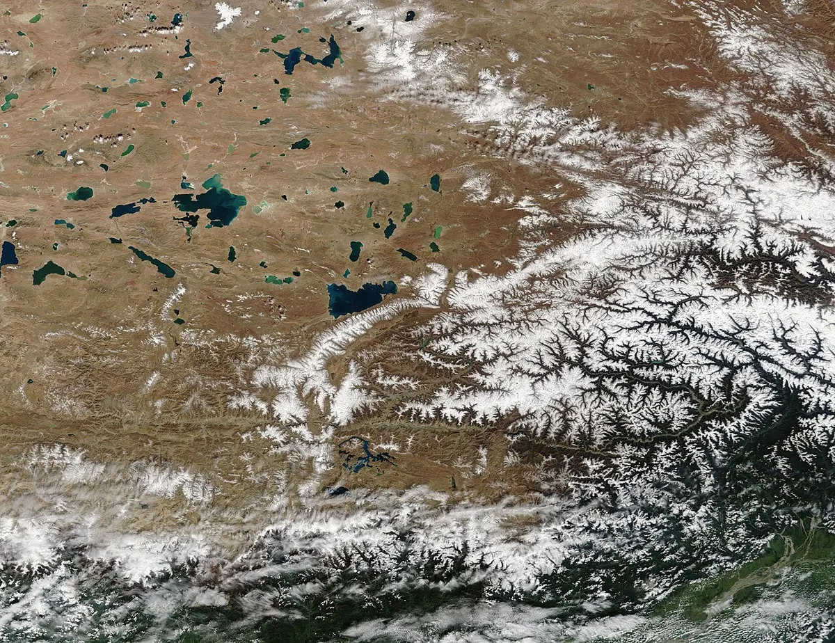
Nepal sits on the step between the first two. From the plain of the Koshi, less than 100 m above the sea, the ground climbs to Everest, 8,849 m, in under 200 km. On the far side it comes down only to about 5,000 m, and there it stays for hundreds of kilometers. Draw a straight line north from the Ganga plain over Everest’s summit into Tibet and you cross a plain, a mountain range and a plateau, the whole subject of this chapter, in about 450 km.
The three are easy to tell apart once you look at their shape rather than their height. A plain is wide, flat and low. A plateau is wide and flat too, but high, with a steep edge on at least one side, which is why the old name for one is a tableland. A mountain is high ground that rises steeply to a narrow top. Plains cover more than a third of the Earth’s land, and by one careful count, the United Nations Environment Programme’s, about a quarter of the land is mountainous.
Where a hill ends and a mountain begins, nobody has ever agreed. In Britain a summit is a mountain once it reaches 2,000 feet, about 610 m. The Siwalik range, which Nepal calls the चुरे (Chure), reaches 1,500 to 2,000 m along much of its length and is still called hills. Nepali is relaxed about it too. CDC’s Grade 9 course calls this topic पहाड, उच्च समस्थली र मैदान, mountains, high flat land and plains, while in everyday speech पहाड is the hill country, with the हिमाल, the snow peaks, standing above it. Heights in Nepal are simply on a different scale, and the words grew up to fit.
What lifts the land
Mountains are made by forces you could never feel. The Earth’s outer shell is broken into plates that drift a few centimeters a year, and where they push, pull or carry hot rock up from below, the land slowly changes height. Geographers call these the slow forces, beside the sudden ones, earthquakes and volcanoes, which have a chapter of their own. There are three main ways they raise the land.
The first is squeezing. Push a tablecloth across a table and it rucks up into folds. Layers of rock squeezed from the side do the same, bending into upfolds and downfolds. When the squeeze goes on, whole sheets of rock break loose and slide over one another, stacked like roof tiles, and the crust grows thick. That is how the Himalaya, the Andes and the Alps were all built, which is why the old textbook name for such ranges is fold mountains. Geologists rarely use that name now, because folding turned out to be only part of the story; the stacking of great slabs matters as much.
The second is stretching. Pull the crust apart and it cracks into blocks, like a slab of chocolate bent too far. Some blocks drop and some stay high, and you get a sunken valley between two raised ranges. The textbook example is in Europe: north of Basel the Rhine flows along a dropped block about 350 km long and some 50 km wide, with the Vosges mountains of France on one side and the Black Forest of Germany on the other, the two raised edges of the same crack. Nepal has one too: the upper Kali Gandaki, behind the Annapurna range, runs through a dropped block of its own.
The third is building from below. Hot rock rising from deep inside can lift the ground, and lava pouring out can pile it up. A single volcano makes a cone, like Kilimanjaro. Lava pouring from long cracks again and again can drown a whole country. About 66 million years ago, over roughly a million years, flows of runny lava covered much of western India in layer after layer. Today they are the Deccan Traps, more than 2 km of lava rock over half a million square kilometers, the core of the Deccan Plateau.
Plateaus come from all three. Tibet is the greatest, about 2.5 million square kilometers at an average height of more than 4,500 m, and it was made by squeezing: India pushing into Asia didn’t only raise the Himalaya, it thickened and lifted all the land behind them. The Altiplano of South America, the second highest, lies between two lines of the Andes in the same way. The Deccan is lava. Others are old land lifted as a block, or high ground worn level by water and ice.
Plains are mostly made the other way, by laying things down. Rivers carry sand and mud out of the mountains and spread it where the land is low, and the plain is what builds up. The Indo-Gangetic plain, about 700,000 square kilometers from Pakistan to Bangladesh, is the waste of the Himalaya, carried down by the Indus, the Ganga and the Brahmaputra and their tributaries, Nepal’s rivers among them, and a seventh of the world’s people live on it. Even the Siwalik hills are the Himalaya’s own rubble: sandstone and gravel washed down between about 16 and 5 million years ago, then lifted in their turn along a fault at the range’s southern edge.
All of this is slow. The Himalaya are still rising, by a few millimeters a year, about the thickness of a coin. But a few millimeters a year is a kilometer in a few hundred thousand years, and India has been pushing for about 50 million. The range isn’t finished: GPS stations on the mountains measure them going up and north today. What stops them growing forever is the rain, the ice and the rivers wearing them down as fast as they can, and why that hardly lowers them is a story of its own, told in Why Is Everest Still Rising?
Three ranges
The world’s great mountain ranges look alike from a distance, all snow and rock, but cut across they are not built the same way. Three are the classic examples, and Nepal’s is one of them.
The Himalaya are what happens when two continents meet. India’s plate carried a continent north, and when the ocean in front of it was gone, continent met continent. Continental rock is too light to sink into the mantle, so neither side could go under, and the rock had nowhere to go but up and back. The range runs about 2,400 km from the bend of the Indus in the west to the bend of the Brahmaputra in the east. Behind it lies Tibet, the highest and largest plateau in the world, and along the range itself there isn’t one volcano.
The Andes are what happens when sea floor meets a continent. Off the coast of South America the floor of the Pacific, heavy and cold, bends down into a trench more than 7,000 m deep and slides under the continent. As it sinks, water squeezed out of it helps the rock above it melt, and the melt rises to make a line of volcanoes along the range. The Andes run about 7,000 km down the whole western side of South America, the longest mountain range on any continent, and their highest peak, Aconcagua, is nearly 7,000 m. Cut across, they rise straight from the trench, which is why the drawing starts under the sea. The Altiplano behind them is about 3,750 m high.
The Alps are what happens when the pieces are smaller. Africa and Europe have been closing on each other for tens of millions of years, and the sea-floor rock caught between them was folded and thrust up in great sheets. The Alps curve about 1,200 km across Europe, and their highest peak, Mont Blanc, is about 4,800 m, a little more than half of Everest. Cut across, they are narrow, about 200 km, where the Himalaya and Tibet together run to more than a thousand. They are also where the subject grew up. Naturalists studying the Alps’ rocks from the 1700s on worked out many of geology’s first ideas there, and for a century explained the folded ranges with a theory that turned out to be wrong, until moving plates replaced it in the mid-1900s.
Rivers that were there first
Look at a map of Nepal’s rivers and something odd shows up. You would expect the highest mountains to be the divide, rain on the south side running south and rain on the north side running north. For most of the range that’s true. But a few rivers start behind the Himalaya, on the Tibetan side, and flow straight through the highest part of the range to India.
The Kali Gandaki is the most striking. It rises on the Tibetan border north of Mustang and runs south between Dhaulagiri, 8,167 m, and Annapurna I, 8,091 m. Where it passes between them its bed is about 2,520 m above the sea, more than 5.5 km below the top of Annapurna I, and it is often called the deepest gorge on Earth, though how to measure a gorge’s depth is argued. The Arun does the same in the east: it gathers its water in Tibet, north of the main range, and cuts through it not far east of Everest. The Karnali in the west crosses the range too, and beyond Nepal so do the Sutlej, the Indus and the Brahmaputra.
How can a river run through a wall of mountains? The usual answer is that the river was there first. Before the Himalaya rose to their full height, the rivers already flowed south from Tibet across lower ground. As the land rose under them, slowly, a few millimeters a year, each river kept cutting down into it just as fast, the way a saw held still cuts through a log pushed up into it. The mountains rose on either side, and the river stayed in its groove. A river older than the land it crosses is called antecedent, from the Latin for going before.
The man who made the case for the Arun was Lawrence Wager, a British geologist. In 1933 he was on the British Everest expedition, and with Percy Wyn-Harris he climbed to about 8,570 m without bottled oxygen, the highest anyone would climb without it for the next 45 years. Four years later he published a paper on the Arun. He noticed that in Tibet the river runs along the downfolds of the rock, where water ought to go, and then plunges through the Himalaya in a gorge along an upfold, where water ought not to go. He took the river to be older than the range, and he went a step further: cutting so deep a gorge takes a great weight of rock off the crust, and the land beside it rebounds, the way a boat rides higher when its cargo is unloaded. That, he suggested, helped lift the great peaks near the gorge.
For decades most geologists agreed that the big rivers are older than the range, and many books give it as settled. It isn’t, quite. From the 1980s on, careful mapping showed that the upfolds the big rivers cut through are among the youngest folds in the range, younger than the mountains around them. A river can’t simply have been there before a fold that is younger than the mountains it crosses, so some geologists turned back to Wager’s second idea: perhaps the rivers, cutting their gorges extra fast, made the rock beside them rise. In 2024 a team of geologists went further and argued that the Arun and the Tista aren’t antecedent at all: their gorges, they said, were cut backward from the south, the river’s head eating north into the range until it broke through and took over water that once went the other way. The Swedish explorer Sven Hedin saw that kind of eating back at work long before. In 1907 he stood on the Kore La, the low pass at the head of the Kali Gandaki, only about 96 m above the Tsangpo, the Brahmaputra’s upper course, just to the north, and he wrote that “the tentacles of the Kali Gandak are eating back northwards into the mountains much more quickly than the Tsangpo is eroding its valley.”
So the honest answer is that some of these rivers seem to be older than the mountains, and nobody yet knows which, or whether it is true of any of them. The rivers may even be shaping the mountains in return, as Wager thought. In 2024 another team worked out, from the shapes of the rivers’ beds and a computer model, that a capture of this kind in the Koshi’s basin, about 89,000 years ago, sped up the cutting downstream, and that the land around may have risen a little in response, enough for 15 to 50 m of Everest’s height. It is one model, and a new idea, but it shows how tangled the question is.
How high is Everest?
Everest has had a height for longer than it has had a name. In the 1840s surveyors of the Great Trigonometrical Survey of India, not allowed into Nepal, measured the angles to the snow peaks from stations on the plains more than 170 km away. The peak was listed only as Peak XV. The sums were done by the survey’s “computers”, and the chief of them was Radhanath Sikdar, a mathematician from Calcutta who had joined the survey at 18. In 1852 his calculations from six observations showed that Peak XV was higher than Kangchenjunga, until then thought the highest mountain in the world.
The survey spent years checking the work, wrestling with the way air bends light over long distances. In March 1856 the Surveyor General, Andrew Waugh, announced the height: 29,002 feet, about 8,840 m. The sums had come to exactly 29,000 feet, and he is said to have added two, so that nobody would take a round number for a guess.
Since then the mountain has been measured again and again, and the number keeps moving. The Survey of India, measuring in 1952–54, found 8,848 m, and that figure stood for half a century. Chinese surveyors in 1975 got almost the same. In 1999 an American team carried a GPS receiver to the top and got 8,850 m. In 2005 China measured the rock under the snow and announced 8,844.43 m, with 3.5 m of snow and ice on top. Nepal and China then disagreed for years about which counted, the rock or the snow, until in 2010 both accepted 8,848 m for the snow and China’s figure for the rock.
Then, on 25 April 2015, the Gorkha earthquake moved the ground under much of central Nepal, and nobody knew whether Everest had moved with it. Nepal decided to measure the mountain itself, for the first time. Its surveyors reached the summit in May 2019, and a Chinese team followed in 2020. On 8 December 2020 the two countries announced one height, measured to the top of the snow: 8,848.86 m.
That number will change too, for three reasons. The first is the snow. The top of Everest is a cap of snow and ice whose thickness changes with the weather, and the summit everyone stands on is the snow, not the rock. Mont Blanc shows how much that matters. France has measured it every two years since 2003, and it has come out anywhere from 4,805.59 m, after a long drought in 2023, to 4,810.02 m, while its highest rock, about 40 m away from the snowy top, sits at about 4,792 m. The second is the sea. Heights are measured from sea level, and sea level under a mountain 700 km from the nearest coast is itself something to be worked out, from the pull of gravity; each new survey works it out better. The third is the mountain. Everest is still moving: by GPS it is going up a few millimeters a year and creeping north-east a few more.
So the highest point on Earth is a number with a date attached. Every measurement is true for its year, and the next one, with better instruments and a mountain a little higher, will be slightly different. That is what it means to live on land that is still being built. The ground under Nepal is not finished, and the climb from the Ganga plain to Tibet is a picture of one moment in a very long push. To watch India’s whole journey north, and the land closing up around it, open Earth Through Time; to see Everest beside the deepest trench, the farthest summit from the Earth’s center and the other record places, open Earth’s Extremes.
Found a mistake? Please tell us.