
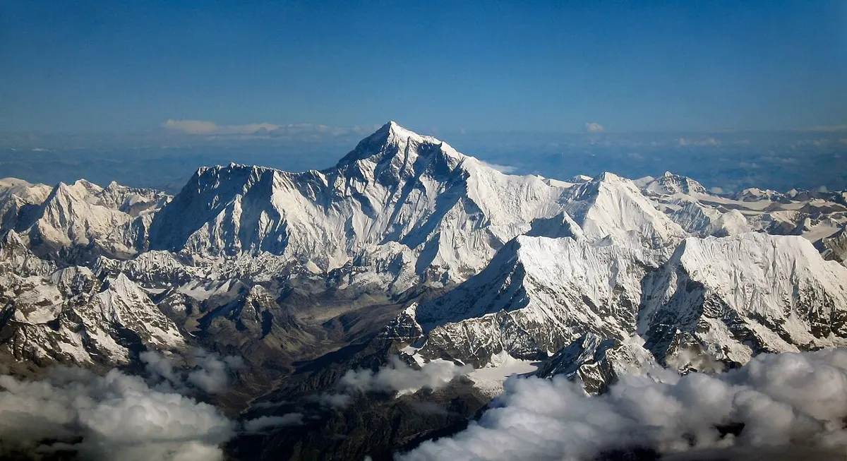
In December 2020, Nepal and China announced a new height for Sagarmatha, Mount Everest: 8,848.86 m, measured by surveyors who carried a GPS receiver to the summit. It will not stay that height. GPS stations on the mountains show that Everest is still rising, by a few millimeters a year, and that the whole of Nepal is being squeezed: the Terai is creeping towards Tibet by about 2 cm every year.
The rock at the summit is limestone made on the floor of a sea, full of the broken shells of sea animals. Something has lifted that sea floor nearly 9 km into the sky, and it is still pushing. India, carried on a huge slab of the Earth’s outer shell, is moving north into Asia at about 4 cm a year, about as fast as your fingernails grow.
What could push a whole country? The answer is heat, deep inside the Earth. And here is the strange part: nobody has ever been there. The deepest hole ever drilled, the Kola Superdeep Borehole in Russia, stopped in 1989 at 12.3 km: less than 0.2% of the way to the center. Everything we know about the inside of the Earth, we have worked out from the outside. This topic shows how, and how the heat inside builds mountains while rain and rivers wear them down.
Inside the Earth
In Grade 6 you met the Earth’s layers: a thin crust, a thick rocky mantle, and a core of iron and nickel, liquid outside and solid inside. Here they are with their sizes:
| Layer | Depth (km) | State | Made of (mostly) | Density (g/cm³) |
|---|---|---|---|---|
| crust | 0 to 5–70 | solid rock | granite-like rock under continents; basalt under oceans | 2.7–3.0 |
| mantle | to 2,890 | solid rock (that flows very slowly) | peridotite: rock rich in iron and magnesium | 3.3–5.6 |
| outer core | 2,890–5,150 | liquid | molten iron and nickel | 9.9–12.2 |
| inner core | 5,150–6,371 | solid | iron and nickel | 12.8–13.1 |
The crust is thin: about 7 km under the oceans and about 35 km under most continents, but about 70 km under the Himalaya and Tibet. If the Earth were an apple, the crust would be about as thin as its skin.
But how can anyone know this? Nobody has seen the mantle, let alone the core. The first clue comes from simply weighing the Earth.
The Earth’s average density was first measured in 1798, by the English scientist Henry Cavendish, who weighed the Earth by measuring the tiny pull between lead balls in a shed. His answer, 5.45 times the density of water, was within about 1% of today’s 5.51. It proved that the Earth’s heart is heavy. To find out what it is like, we need to look inside, and the only way to look is to listen.
The Earth’s average density is about 5.5 g/cm³, but the rocks at its surface are about 2.7 g/cm³. Which conclusion does this support best?
Pick an answer to see why.
Listening to earthquakes
You learned in Grade 9 that sound and other mechanical waves need a medium to travel through, and that their speed depends on the medium Grade 9: Mechanical waves. When an earthquake strikes, the energy released spreads through the whole Earth as seismic waves, and instruments called seismometers, all over the world, record them. Two kinds travel through the inside of the Earth:
- P waves (primary waves) are longitudinal, like sound: the rock is squeezed and stretched along the direction the wave travels Grade 9: Longitudinal and transverse waves. They are the fastest, about 6 km/s in the crust, so they arrive first. They can travel through solids, liquids and gases.
- S waves (secondary waves) are transverse: the rock is shaken from side to side, across the direction the wave travels. They are slower, about 3.5 km/s in the crust, so they arrive second. They can travel only through solids.
Why only solids? A sideways shake only travels if each bit of material, pushed sideways, pulls its neighbors along with it and is pulled back. A solid resists being bent out of shape, so it does. A liquid doesn’t resist a change of shape at all: it just flows. Push a spoon sideways through water and the water slides out of the way; nothing springs back. So an S wave dies at the edge of any liquid.
Because the two waves travel at different speeds, the gap between them tells you how far away the earthquake was, just as the gap between lightning and thunder tells you how far away a storm is.
The shadow on the far side
Here is how waves let us see inside. A seismic wave travels faster in deeper rock, which is squeezed harder and stiffer. So the waves don’t go in straight lines: they bend, the way light bends when it passes from air into glass Grade 10: Refraction of light, and most curve back up to the surface. Where they come up, and when, depends on what they have passed through. Every large earthquake is an X-ray of the whole planet.
Early in the 1900s, seismologists noticed something strange. After a big earthquake, stations within about 104° of it (measured round the Earth from the center, 1° being 111 km along the surface) recorded both P and S waves. But stations farther away than 104° recorded no S waves at all. And between about 104° and 140° there were hardly any P waves either: a ring round the far side of the Earth, a shadow zone, where the earthquake was strangely quiet. Beyond 140°, the P waves came back, but late.
Try it. Pick a model of the Earth, send out waves, and see if it gives the shadow zones real earthquakes give.
The only model that fits is one with a liquid outer core. S waves can’t cross a liquid, so the core casts a huge S-wave shadow over the whole far side of the Earth. P waves can cross it, but they slow down from about 13.7 km/s to about 8 km/s as they enter it, and so bend sharply. That bending leaves a ring with no P waves, and focuses them farther round, beyond 140°. The size of the shadow tells you the size of the core: it starts 2,890 km down. (Strictly, an S wave that hits the core can set off a P wave in the liquid, which can turn back into an S wave as it comes out on the far side; seismologists do record these. But no S wave crosses the core as an S wave.)

Seismometers more than about 104° from an earthquake never record its S waves. What does this show?
Pick an answer to see why.
More clues from the inside
Seismic waves give the layers’ depths, and their speeds in each layer. Other clues say what the layers are made of.
- Meteorites. Some meteorites are rock; others, the iron meteorites, are almost pure iron and nickel. They are pieces of small planets, broken up long ago, that had cores of their own. The Earth is thought to be made of the same stuff, and iron is the only common element dense enough to make the core.
- Squeezing rock in the laboratory. In a diamond anvil cell, a tiny sample is squeezed between the points of two diamonds and heated with a laser. Such experiments have reached the pressure at the Earth’s center, about 3.6 million times the pressure of the air. They show how fast seismic waves would travel through iron, or through mantle rock, at each depth, so the waves’ speeds can be matched to the materials. They show too that iron melts at a higher temperature when it is squeezed harder. The center of the Earth, at about 5,000–6,000 °C, is hotter than the outer core, but it is solid because the pressure there is so great.
- The magnetic field. You learned in Grade 8 that the Earth’s magnetism comes from molten iron moving in the outer core Grade 8: Why the Earth is a magnet. The field is always changing, and its changes tell us how fast the iron flows. The magnetic pole in the north has moved over 2,200 km since it was first found in 1831; in the early 2000s it was moving 50–60 km a year, and as of 2025 about 35 km a year. To change the field that fast, the iron in the outer core must flow at roughly 10–20 km a year: a liquid, and a runny one.
A solid that flows
Now for the most surprising thing about the mantle. S waves pass right through it, so it is solid. Yet over millions of years, it flows.
You may have seen a solid flow without knowing it. A glacier is solid ice: you can walk on it, and cut steps in it. Yet it flows downhill like a very thick river. The Khumbu Icefall, which climbers cross on the way up Everest from the Nepal side, moves about a meter a day. The ice crystals slowly slide and change shape under the glacier’s own weight. Hot rock under great pressure can do the same, just far more slowly.
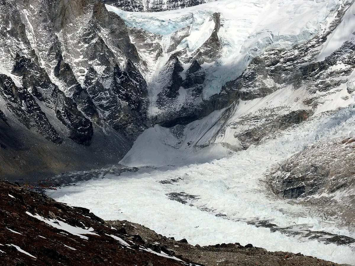
The mantle’s rock is hot, from about 1,300 °C just under the plates to over 3,000 °C at the bottom, close to its melting point, though not melted. Strike it and it rings like a bell, carrying seismic waves. But push on it for thousands of years, and it slowly creeps and flows, at a few centimeters a year. It is about 10²⁰ times as stiff as honey, but it moves.
How do we know the mantle flows? One clue is the ground in the far north. Twenty thousand years ago, ice sheets up to 3 km thick covered Scandinavia and Canada. Their weight pushed the crust down into the mantle, and the mantle rock slowly flowed out of the way. The ice had melted away by about 8,000 years ago, and the land is still rising back, as the mantle flows back in underneath: around the Gulf of Bothnia, between Sweden and Finland, by nearly 1 cm a year. Harbors built there a few hundred years ago are now high and dry, and old beaches are found as steps, hundreds of meters above the sea. From how fast the land rises, we can work out how stiff the mantle is.
The top of the mantle and the crust together make a cold, stiff, brittle shell about 100 km thick, the lithosphere (from the Greek for “stone sphere”). It is cracked into about a dozen large pieces and many small ones, the tectonic plates. Below it, the hotter mantle flows more easily: this layer is the asthenosphere (“weak sphere”), and the plates slide over it.
The mantle carries S waves, and S waves can’t cross a liquid. Yet the mantle flows. How can both be true?
Pick an answer to see why.
Where the heat comes from
The inside of the Earth is hot, and the heat is slowly leaking out through the surface. Measured in mines and drill holes all over the world, the ground gets warmer as you go down, by about 25 °C for every kilometer near the surface, and heat flows out, all the time, everywhere. Altogether, about 44 terawatts (44 × 10¹² W) flows out of the Earth: more than twice all the energy people use (about 20 TW, as of 2023).
It comes from two sources, in roughly equal parts:
- Heat left over from the Earth’s birth. As the Earth formed, 4.5 billion years ago, rocks crashing together heated it, and iron sinking to the core released still more energy Grade 8: A young, violent Earth. The Earth has been cooling ever since, but a planet this size cools very slowly.
- Radioactive decay. Rocks contain a little uranium, thorium and a kind of potassium, potassium-40, whose atoms are radioactive: now and then one breaks apart, giving out energy that ends up as heat. Their half-lives are long, 1.3 billion years for potassium-40, 4.5 billion for uranium-238, 14 billion for thorium-232, so they are still heating the Earth today.
The mantle’s slow boil
In Grade 8 you watched water go round in a beaker heated from below: warm water rises, cools at the top, and sinks again, a convection current Grade 8: Convection. The mantle is heated from below by the hot core, and by its own radioactivity, and cooled from above at the surface. So, though it is solid, it convects, millions of times more slowly than the water.
But the mantle’s convection doesn’t look like neat loops in a beaker. The plates themselves are part of it: they are its cold, stiff top layer.
- At a mid-ocean ridge, plates move apart. Hot mantle rock rises to fill the gap; as it rises, the pressure on it falls, and some of it melts. The melt comes up as new sea floor.
- The new sea floor moves away from the ridge, cooling as it goes, and gets thicker and denser. After tens of millions of years it is denser than the hot mantle under it.
- Where an old, cold plate meets another plate, it sinks back into the mantle. This sinking is called subduction. The sinking slab pulls the rest of its plate along behind it, like a tablecloth sliding off a table: this slab pull is the strongest of the forces moving the plates.
- Hot columns of rock, mantle plumes, rise from deep in the mantle, some perhaps from right above the core, and make volcanoes in the middle of plates, as in Hawaii.
This is not only a picture. Seismic waves travel a little faster through cold rock and a little slower through hot rock. Using millions of records from thousands of earthquakes, seismologists build three-dimensional maps of the mantle, the way a CT scanner builds a picture of your body from X-rays. This is called seismic tomography. The maps show cold slabs of old sea floor sinking deep into the mantle under Japan and South America, and under India and the Himalaya, the cold remains of the ocean that once lay between India and Asia. And they show hot, slow rock rising under Iceland, Hawaii and Africa.
What is the strongest force driving the plates?
Pick an answer to see why.
Where plates meet
The plates move a few centimeters a year, but they are thousands of kilometers across, so where they meet, they build some of the biggest features on the planet. Most of them are hidden under the sea. The mid-ocean ridges wind about 65,000 km round the globe, the longest mountain chain on Earth. The ocean trenches are the deepest places on Earth: the Challenger Deep in the Mariana Trench, in the Pacific, is about 10,935 m deep (as measured in 2021), deeper than Everest is high. And the sea floor is dotted with tens of thousands of seamounts, underwater volcanoes, many in long lines.
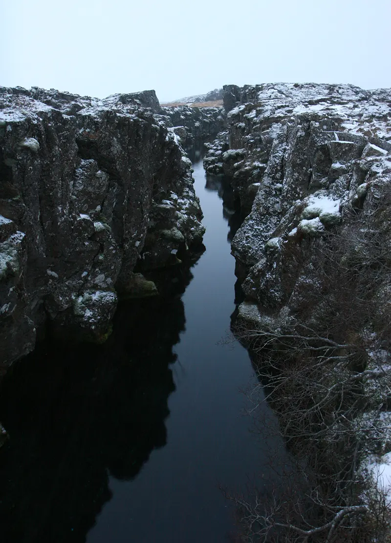
Why is there almost no sea floor older than about 200 million years, when some continental rock is over 4 billion years old? Because sea floor is made at ridges and destroyed at trenches, while continents, too light to sink, stay on top. That is a topic of its own: Why Is the Sea Floor So Young?
Under which kind of plate meeting do you expect a deep trench in the sea floor and a line of volcanoes beside it?
Pick an answer to see why.
India meets Asia
About 120 million years ago, India was part of a huge southern continent, Gondwana, next to Africa, Antarctica and Australia. It broke away and moved north across an ocean called the Tethys, at times faster than 15 cm a year, faster than any continent moves today, pulled along by the Tethys sea floor sinking under Asia ahead of it. Long before, on the northern edge of India, under shallow seas, the shells of sea animals had piled up and become limestone, the rock now at the top of Everest Grade 8: The sea at the top of the world.
About 50 million years ago the last of the Tethys sea floor sank, and India hit Asia. A continent is too thick and light to sink far into the mantle, so India slowed down, but it didn’t stop. It is still moving north at about 4 cm a year. About half of that, nearly 2 cm a year, is taken up across Nepal; the rest squeezes Tibet and the land beyond.
India doesn’t slide under Nepal smoothly. The upper part of the fault between them, the Main Himalayan Thrust, is stuck. Below about 20 km, the rock is hot enough to creep, and India slides on north. But above that, the two sides are locked together, so the creeping drags the edge of Nepal along, and the rock above the stuck part bends and squeezes like a spring being wound up. As it is squeezed, the high Himalaya is pushed up. This is what the GPS stations measure: Everest rises a few millimeters every year.
Every so often, after centuries, the stuck part can’t hold, and the fault slips in seconds: a great earthquake. On 25 April 2015, the Gorkha earthquake began 10–15 km under Barpak in Gorkha district. The fault unzipped eastwards for about 150 km, under Kathmandu, and Nepal’s side slid south over India by several meters. In those seconds, the Kathmandu valley was lifted by roughly a meter and moved 1.5–2 m south, while the land to its north, where the bent rock sprang back, sank by more than half a meter. Nearly 9,000 people died.
Between earthquakes, why does the high Himalaya rise?
Pick an answer to see why.
Building up, wearing down
A mountain range is a contest between two kinds of process. The heat inside the Earth builds up: plates collide and lift the land, volcanoes pile up lava, ridges make new sea floor. Water, ice, wind and gravity wear down: frost splits the rock, landslides drop it into the valleys, and rivers carry it away. (How water does that is a topic of its own: What Does Water Do to Rock?)
Nepal is one of the fastest-wearing places on Earth. The monsoon pours rain on steep, broken slopes, and every year the Ganga and Brahmaputra, with all their Himalayan rivers, carry about a billion tonnes of sand and mud to the Bay of Bengal. There it has piled into the Bengal Fan, the biggest heap of sediment on the planet, up to 16 km thick and 3,000 km long. Nearer home, the worn-down Himalaya built the flat plains of the Terai, and the Churia hills (the Siwaliks) are made of sand and gravel worn from the Himalaya over the last 20 million years, then caught up in the push and folded into hills themselves.
But wearing a mountain down doesn’t lower it as much as you would think, because mountains float.
Mountains have roots
The crust is less dense than the mantle under it: about 2.8 g/cm³ against 3.3. So the crust floats on the mantle (slowly, since the mantle flows slowly), like a block of wood floating in water. A thick block floats with its top higher, but also with its bottom deeper. The same goes for the crust: where it stands high, it also has a deep root below, pushing down into the mantle. This balance is called isostasy (Greek for “equal standing”).
The contest over time
So does a mountain grow forever while the push goes on? No: the higher and steeper it gets, the faster rain and rivers wear it down. Eventually wearing down catches up with building up, and the height of the range levels off, while rock keeps moving up through it and being carried away, like water flowing through a full bucket with a hole in it. When the push stops, the range is slowly worn down. The Aravalli hills of India were once a great mountain range, more than a billion years ago.
The two contests happen on very different scales, of size and of time:
| Process | How fast | How long it lasts | How big |
|---|---|---|---|
| an earthquake | a fault slips meters in seconds | seconds to minutes | a fault up to hundreds of km long |
| a landslide | meters a second | minutes | meters to kilometers |
| a volcano erupting | lava builds a cone meters a day | days to years | a cone up to a few km high |
| a river cutting its valley | millimeters a year | thousands to millions of years | a valley kilometers deep |
| plates moving, mountains rising | centimeters a year | tens of millions of years | thousands of km |
| mantle convection | centimeters a year | hundreds of millions of years | the whole mantle, 2,890 km deep |
Make a mantle in a pan
Questions
Which of these is evidence that the Earth’s outer core is liquid?
Pick an answer to see why.
Glacier ice and the mantle are alike because both
Pick an answer to see why.
A seismometer records the P wave of an earthquake and, 30 s later, the S wave. Taking P waves at 6.0 km/s and S waves at 3.5 km/s, how far away was the earthquake? Why does one station not tell you where it was?
Answer
The gap is Δt = d/3.5 − d/6.0 = 0.119 d, so d = 30 ÷ 0.119 = 252 km (about 250 km). One station gives only the distance, so the earthquake could be anywhere on a circle of radius 250 km round it. With three stations, the three circles meet at only one place: the earthquake.
Explain how seismic waves show that the Earth has a liquid outer core, and how they show where it begins.
Answer
S waves are transverse, and can only travel through solids. Stations more than about 104° from an earthquake never record S waves, so something in the Earth’s middle stops them: a liquid. P waves cross the liquid, but they slow down sharply as they enter it, from about 13.7 to about 8 km/s, and bend, so they leave a ring between about 104° and 140° where hardly any P waves arrive. The size of the shadow zones depends on the size of the core: working back from them, the core begins 2,890 km down.
The mantle is solid, yet it convects. Explain (i) how this is possible, (ii) what heats it, and (iii) what evidence shows that the mantle can flow.
Answer
- i.Hot rock under great pressure, close to its melting point, creeps very slowly when pushed for a long time, as glacier ice does: over seconds it is a stiff solid (it carries S waves), but over thousands of years it flows, a few centimeters a year.
- ii.It is heated from below by the hot core, which still holds heat from the Earth’s formation, and from within by the decay of radioactive uranium, thorium and potassium-40. It is cooled at the top, through the plates.
- iii.Where thick ice sheets melted away 8,000–10,000 years ago, in Scandinavia and Canada, the land is still rising, by up to about 1 cm a year, as mantle rock flows back under it. Seismic tomography also shows cold slabs of sea floor that have sunk hundreds of kilometers into the mantle.
Draw a model, a labeled cross-section, of the Himalaya: show India, Nepal and Tibet, the fault between them, the direction of movement, and where rock is being raised and where it is being worn away. Use it to explain why Everest is still rising, and why it isn’t far higher than it is.
Answer
The drawing should show the Indian plate sliding north under Nepal and Tibet along a gently sloping fault (the Main Himalayan Thrust), with arrows: India moving north at about 4 cm a year, about 2 cm a year of it taken up under Nepal. The Himalaya and Tibet stand high, with a thick crust and a deep root. Rivers flow south, carrying sediment to the Terai and the Bay of Bengal (see Figure 36.7).
Explanation: India keeps moving north; the deep part of the fault creeps, but the shallow part is stuck, so the rock above it is squeezed and the high Himalaya is pushed up, a few millimeters a year; great earthquakes release some of the strain every few centuries. At the same time, frost, landslides and monsoon rivers wear the mountains down, faster the higher and steeper they are. Over millions of years the wearing down nearly balances the building up, so Everest stays at about 9 km instead of growing for ever. Because the crust floats on the mantle, wearing rock away also lets the range float up a little, which slows the lowering.
Explain, with an example of each, how internal processes build up features of the Earth’s surface, and how surface processes wear them down. Why do these happen on such different time scales?
Answer
Building up, powered by the Earth’s internal heat: plates colliding raise mountain ranges (the Himalaya, a few mm a year over tens of millions of years); plates moving apart make mid-ocean ridges and rift valleys (the Mid-Atlantic Ridge, Iceland’s rift); volcanoes build cones and seamounts (Hawaii, the Andes). Wearing down, powered by the Sun (which drives the water cycle) and by gravity: frost splitting rock, landslides in the monsoon, rivers carrying sediment to the Terai and the Bengal Fan, waves wearing coasts.
The time scales differ because the processes differ in speed and size: an earthquake or a landslide happens in seconds or minutes, but each moves only a little rock; plates move only centimeters a year, but over tens of millions of years that is thousands of kilometers. A feature like a mountain range is the result of both, added up over millions of years.
Under the Tibetan Plateau, the crust is about 70 km thick; under the Ganga plains, about 35 km. Taking the crust’s density as 2.8 g/cm³ and the mantle’s as 3.3 g/cm³, how high would you expect the plateau to stand above the plains? (Tibet is about 5 km high.)
Hint
The extra crust, 35 km of it, is the plateau’s height h above the plains plus its root r below. Floating means the extra crust weighs the same as the mantle it replaces: 2.8 × 35 = 3.3 × r.
Answer
The extra 35 km of crust must weigh the same as the mantle its root replaces: 2.8 × 35 = 3.3 × r, so r = 98 ÷ 3.3 = 29.7 km. The height above the plains is h = 35 − 29.7 ≈ 5.3 km, close to Tibet’s real height of about 5 km. The plateau stands as high as a crust that thick should float.
Where to go next
- Why Is the Sea Floor So Young? No sea floor is much more than 200 million years old, yet some continental rock is 4 billion. The magnetic stripes on the ocean floor, and the evidence for plate tectonics.
- What Does Water Do to Rock? Frost splitting rock, limestone dissolving into caves, and water helping rock melt under volcanoes: the wearing-down side of the contest.
- How Old Is the Earth? The radioactive elements that heat the Earth are also its clocks.