
If you could stand in the middle of the Kathmandu Valley 30,000 years ago, where Kathmandu’s streets are now, you would need a boat. Much of the valley was a lake, tens of meters deep, ringed by the same forested hills you see today. The old story says that the bodhisattva Manjushri cut a gap in the hills at Chobhar with his sword, the water drained out, and people came to live on the land it left behind.
Geologists tell the story differently, but the ending is the same. The lake was there, on and off, for about a million years, and every river that ran into it dropped mud on its floor. When the lake finally drained, as the Bagmati cut down through its outlet in the south-west, it left a flat floor of soft, fine-grained mud, hundreds of meters deep in places. That black lake clay is why the valley could grow two or three crops a year, why Bhaktapur’s potters have clay to work, and why about three million people live there today. It is also why an earthquake shakes the valley harder than the rock around it.
Water, soil, the dangers of the land and the climate: these have decided where people live for as long as there have been people. This topic shows how, with evidence, and asks you to explain it the way a scientist would.
Water first
Every person needs about 2 to 3 liters of water a day to drink, and much more to cook and wash: the World Health Organization reckons 50 to 100 liters a day per person for all a household’s needs. Animals and fields need far more. Water is heavy, and before pipes and pumps it had to be carried. So the first question for any settlement was always: where is the water?
The answer shows on every map. The first cities in the world grew up beside rivers in dry lands: along the Tigris and Euphrates in Mesopotamia, the Nile in Egypt, the Indus in today’s Pakistan, and the Yellow River in China. The river gave drinking water, water for the fields, fish, and a road for boats.
In Nepal, water decided settlements in a special way. In the hills, a village often sits high on a ridge, above the river, and its water comes from a spring, a place where water that soaked into the hillside comes out of the ground. People carried it up the slope in a gagri every day. In the Kathmandu Valley, the Licchavi kings and their people, 1,500 years ago, built dhunge dhara (stone spouts, hiti in Newari): channels that led groundwater and canal water to carved spouts in sunken courtyards, where anyone could fill a pot.
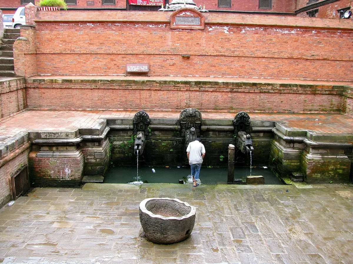
Today the valley’s three million people need far more water than its spouts, wells and rivers can give. The groundwater under it has been pumped faster than rain can refill it, and the water table has fallen. That is why a tunnel about 27 km long was dug through the mountains to bring water from the Melamchi River, in Sindhupalchok. Water first reached the valley through it in 2021, more than 20 years after the project began.
Why were the first cities, like those along the Nile and the Indus, built beside rivers in dry lands?
Pick an answer to see why.
Soil from rivers and lakes
Food comes from soil, and soil is not the same everywhere. A good farming soil is deep, holds water without getting waterlogged, and is full of the minerals plants need. The best is often found where water has dropped it.
A river in flood spreads over the flat land beside it, its floodplain, and slows down. As it slows, it drops the fine silt and clay it was carrying, which settle out over the fields (What Does Water Do to Rock?). Each flood adds a fresh layer of mineral-rich soil, ground from rocks far upstream. For thousands of years, the Nile’s summer flood fertilized Egypt’s fields this way, every year. The great plains of the Ganga, which include Nepal’s Terai, are built of silt and sand from the Himalaya, hundreds of meters deep; their flat land, deep soil and water make them some of the most farmed land on Earth.
A lake does the same, more slowly. Rivers carry fine mud into it, and on the still lake floor even the finest clay settles. That is how the Kathmandu Valley got its soil.
The lake formed about a million years ago, when the rising hills dammed the rivers of the valley. Over hundreds of thousands of years its floor filled with sediment, and its level rose and fell. It shrank in stages, and was finally gone only about 12,000 to 10,000 years ago. The flat land it left, the lake bed, is why the valley could feed a large population long before trucks brought rice from the Terai: its soil held water and was easy to dig, and the valley’s mild climate allowed two or three harvests a year. The Newar towns of Kathmandu, Patan and Bhaktapur grew up on it, with their fields around them.
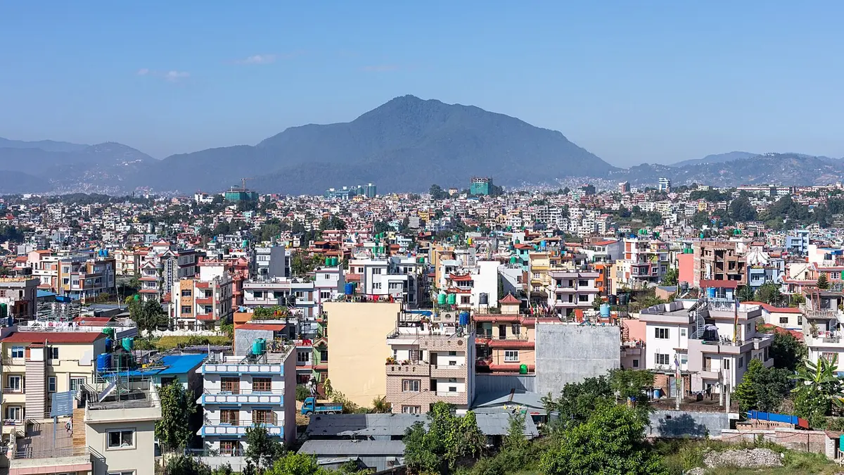
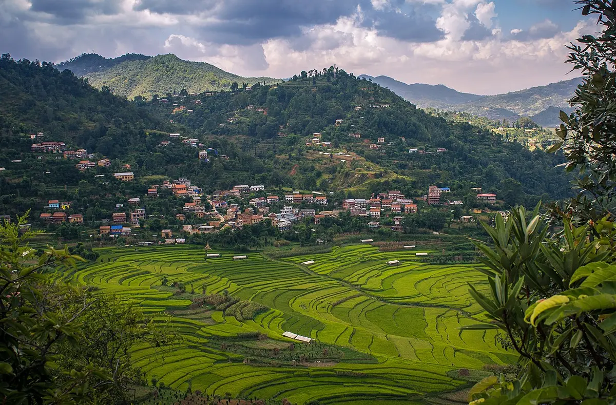
Where flat land is rare, people make it. Across Nepal’s hills, farmers have cut slopes into steps, terraces, held up by walls of stone or earth. A terrace stops the rain from washing the soil away, and a flat terrace can be flooded for rice.
How crowded is a place?
Geographers compare how crowded places are by the population density: the number of people per square kilometer (km²).
Why are river floodplains and old lake beds often good farmland?
Pick an answer to see why.
Living with hazards
A natural hazard is a natural event that can harm people and what they have built. Some come from inside the Earth: earthquakes, volcanic eruptions, and the tsunamis an earthquake under the sea can set off. Some come from the land’s surface: landslides and soil erosion. Some come from the weather: floods, droughts, storms, heat and cold waves. Nepal has most of these, though no volcanoes and no sea.
You might expect people to keep away from dangerous places. Very often they don’t, and there is a reason: the same process that makes a place dangerous often makes it valuable.
- A floodplain is fertile because the river floods it.
- A volcano’s ash weathers into some of the richest soil on Earth. The Indonesian island of Java, crowded with volcanoes, is home to about 150 million people.
- A valley floor is flat and has water, but floods and, in an earthquake, shakes hardest.
- A delta, built by a river at the sea, is flat and fertile but barely above sea level. Bangladesh, built mostly from the sediment of the Ganga and the Brahmaputra, is one of the most crowded countries on Earth.
The river that gives and takes
The Koshi is one of the muddiest rivers in the world: it carries huge loads of sand and silt out of the Himalaya. Where it leaves the hills at Chatara and slows down, it drops so much sand and gravel that it chokes its own channel, and then breaks out sideways into a new one. Over the last 250 years or so it has wandered about 120 km westwards across the plain. Each move spread fertile silt over new land, and buried villages and fields.
To hold it in place, embankments were built along it in the 1950s and 1960s. But a river that drops sand inside its embankments slowly raises its own bed. On 18 August 2008, the Koshi broke through its eastern embankment at Kusaha, in Sunsari, and poured into an old channel it had left more than a century before. Tens of thousands of people in Nepal lost their homes, and about three million people in Bihar, in India, were affected by the flood.
The hills show the trade-offs too. Traditionally, a village in the middle hills stood high on a ridge or slope, not beside the river below it, even though that meant carrying water uphill every day.
The hot, low valley floors, the besi, flooded in the monsoon and were the home of the mosquitoes that carry malaria. People in the hills called the deadly fever of the lowlands aul, and many went down to the besi to farm in the dry season, but lived above it. The steep slopes have their own hazard: landslides, especially in the monsoon, and most of all where forest has been cleared or a road has been cut.
Earthquakes and the old lake
Nepal sits where India pushes into Asia, so it has large earthquakes (Why Is Everest Still Rising?). In 1934 an earthquake of magnitude about 8 destroyed a large share of the buildings of Kathmandu, Patan and Bhaktapur. In 2015 the Gorkha earthquake, magnitude 7.8, killed nearly 9,000 people in Nepal.
The old lake bed makes things worse. Soft sediment shakes more than hard rock, the way a bowl of jelly wobbles more than the bowl. Instruments in the valley in 2015 recorded its soft fill swaying slowly back and forth, about once every 4 to 5 seconds, and going on swaying after the rock around it had begun to calm. In some places, wet sandy layers can even turn to a kind of quicksand in strong shaking (this is called liquefaction). The fertile lake bed that drew people to the valley is also what makes its earthquakes more dangerous.
The chance of a flood
Engineers describe a flood by how rare it is. A 100-year flood is a flood so big that, in any one year, there is a 1 in 100 chance of a flood at least that big. A 10-year flood has a 1 in 10 chance each year.
To find the chance of at least one such flood in many years, first find the chance of none. If the chance of a flood in one year is , the chance of no flood in one year is , and the chance of no flood in n years running is that, multiplied by itself n times. So:
A village has just had a 100-year flood. What is the chance of another one next year?
Pick an answer to see why.
When a hazard goes away: the Terai
Farmers have lived for centuries in the southern Terai, along today’s border with India. But north of them, a broad belt of the Terai below the hills, and the valleys between the hills of the inner Terai, like Chitwan and Dang, were dense forest and tall grassland, and few people lived in them. Their soil was rich and their land flat. What kept people out was a hazard you can’t see: malaria, carried by mosquitoes that bred in its marshes and wet forests. Hill people who went down to it, and armies that tried to cross it, often died of fever.
In the 1950s that changed. From the mid-1950s, with help from the USA and the World Health Organization, Nepal sprayed the walls of houses across the Terai with the insecticide DDT, which killed the mosquitoes that rested on them, and malaria was driven back. The government cleared forest in Chitwan’s Rapti valley and settled hill families on it. Others came on their own, to clear land for farms. Later the East–West Highway, built in stages from the 1960s, joined the Terai’s towns.
What happened next is in the census: Nepal’s modern censuses have counted its people about every ten years since 1952/54.
The Terai’s share of the people rose from about a third to more than half, and its fastest rise came in the 1970s, about twenty years after the spraying began. Today it holds 54% of Nepal’s people on 23% of its land (as of the 2021 census).
What best explains why so few people lived in the forests and inner valleys of the Terai, like Chitwan, before the 1950s, though their soil was rich?
Pick an answer to see why.
Other resources: salt, metal and fuel
Water and soil decide where people can live. Other resources decide where towns grow.
- Trade routes. Kathmandu grew rich partly because it sits on a route between the plains of India and Tibet. For centuries, traders carried salt and wool from Tibet down through the Himalaya, and rice and other grain up. Towns like Tukuche, on the Kali Gandaki, grew up as salt-trading posts.
- Minerals. People go where there are metals and stone to mine, from the copper and iron mined in Nepal’s hills in past centuries to the gold rushes that built whole new cities elsewhere in the world. You met Nepal’s minerals in Grade 8 Grade 8: Grade 8: Minerals in Nepal.
- Fuel. In the 1700s and 1800s, the first factory cities, in Britain, grew up on its coalfields, where the fuel for the steam engines was. In the 1900s, towns grew around oil fields, from Texas to the Gulf.
A resource can also run out, or stop being wanted, and then the town that grew around it can shrink. When trade with Tibet was cut in the 1950s and 1960s, and cheap Indian salt arrived by road, the salt-trading towns of the Himalaya lost their main business.
Which of these is an example of a town that grew because of a resource rather than a good place to farm?
Pick an answer to see why.
When the climate changes
Climate is the weather a place has year after year: how warm, how wet, when the rains come. People choose where to live, and what to grow, to suit it. So when the climate changes, people must change what they grow, or move. Earth’s climate has changed many times (Why Has the Climate Changed Before?), and the evidence of people answering it is all over the world.
When the Sahara was green
Between about 11,000 and 5,500 years ago, stronger summer monsoons reached far into North Africa. The Sahara was grassland with lakes, and hippos and crocodiles lived in places that are now sand. People herded cattle there, and painted them on rocks. Then, over a few centuries to a few thousand years, the rains failed and the desert came back. Archaeologists who dated hundreds of campsites across the eastern Sahara found people leaving it as it dried, for the oases and the valley of the Nile. Farming villages crowded along the river, and on their land Egypt’s first kingdoms grew up, a little over 5,000 years ago.
When the monsoon weakened
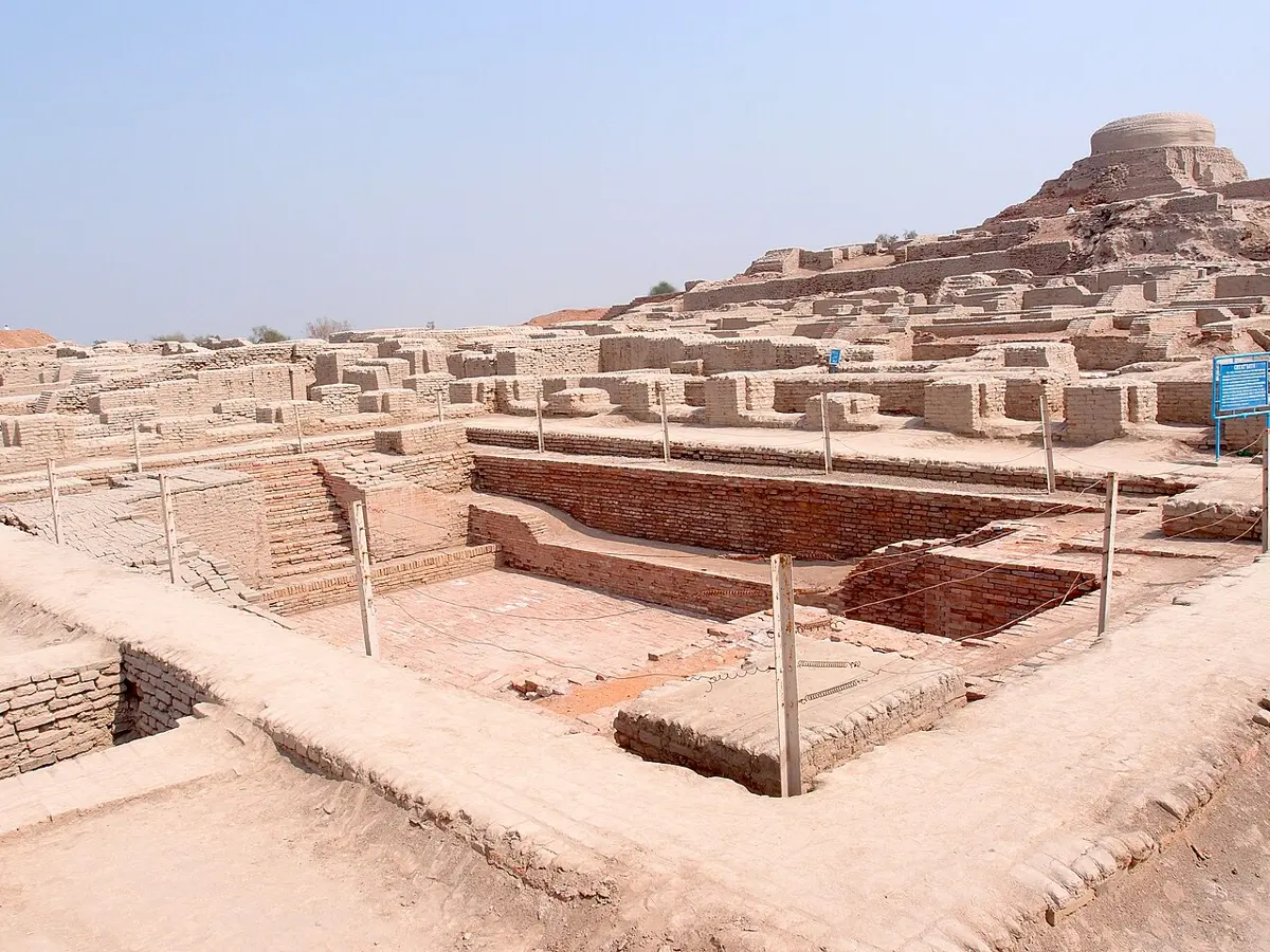
Closer to Nepal, the Indus civilization built great planned cities of baked brick, like Mohenjo-daro and Harappa, about 4,500 years ago, with drains, wells and public baths. From about 4,200 years ago, they emptied. Many scientists now think a long weakening of the monsoon was a large part of the reason. People moved east, towards the Ganga plains and the foothills of the Himalaya, where the rains were more dependable, and lived in smaller villages instead of great cities.
Crops that climb the mountain
As you climb a mountain, the air gets colder, by about 6 °C for every 1,000 m. (This is the lapse rate; the actual value changes with the season and how wet the air is, but 6 °C per 1,000 m is a good average.) That is why each crop has a height above which it is too cold to grow. When the climate warms, every such limit moves up the mountain.
Farmers in the mountains already see this. In lower Mustang, where apples grew well for decades, many farmers report fewer apples and less snow, and new orchards have been planted higher up the Kali Gandaki valley. Mosquitoes that carry dengue now live in hill towns, like Kathmandu, that used to be too cool for them Grade 10: Grade 10: Effects of climate change.
On a mountain 6,000 m high, the climate warms. Why do the plants and animals that live highest up have the biggest problem?
Pick an answer to see why.
Moving away
Sometimes changing what you grow isn’t enough.
Far away in the Pacific Ocean, the island nation of Tuvalu, home to about 11,000 people, has no land more than about 5 m above the sea, and the sea is rising. In 2023 Tuvalu and Australia signed a treaty under which up to 280 Tuvaluans a year can move to Australia to live, work and study, chosen by ballot; the first were chosen in 2025. Its people don’t all want to leave, and many hope to stay; but they now have a choice that a rising sea might one day force on them.
Explaining with evidence
Scientists don’t just say “people moved because of malaria”. They make a claim, back it with evidence, and give the reasoning that links the two, and they check whether something else could explain the same evidence. Here is how that looks for the Terai.
- Claim: The share of Nepal’s people living in the Terai rose from about a third to over half mainly because malaria was controlled from the mid-1950s, which made the fertile, flat land of its forests and inner valleys safe to settle.
- Evidence: a. The census: the Terai’s share was 35% in 1952/54 and 54% in 2021, rising fastest in the 1970s. b. The Tharu, who resist malaria, had lived in its forests and valleys for centuries while few others did. c. Spraying with DDT began in the mid-1950s. d. Censuses from 1981 on counted large numbers of people living in the Terai who had been born in the hills.
- Reasoning: People settle where there is water and good soil, unless a hazard stops them. The Terai’s forests and valleys had the land and the water; malaria was the hazard. Once it was removed, people moved in, and the rise in the census came after the spraying, not before.
- Other explanations to check: Could the Terai simply have had more births? The censuses’ birthplace figures show that migration from the hills was a large part of the rise. Did roads and land offered by the government help too? Yes; they were part of the same opening of the Terai, and a full explanation includes them.
Questions
A floodplain is both the most fertile land in a valley and the most dangerous. Why?
Pick an answer to see why.
The air temperature falls about 6 °C for every 1,000 m you climb. If the climate warms by 3 °C, about how far up does a crop’s cold limit move?
Pick an answer to see why.
Explain why Kathmandu Valley’s soil is so fertile, and how the same feature makes its earthquakes more dangerous.
Answer
The valley floor is the bed of an old lake. For hundreds of thousands of years rivers carried fine mud into the lake, where it settled on the still floor; when the lake finally drained, about 12,000 to 10,000 years ago, it left deep, flat, fine-grained soil that holds water and is easy to farm, where the mild climate allows two or three crops a year. But soft sediment shakes more than hard rock in an earthquake: the sediment fill, hundreds of meters deep, amplifies the shaking and goes on swaying slowly after the rock around it calms, as in 2015, and wet sandy layers can liquefy. So the lake bed that drew people to the valley also makes its earthquakes worse.
A town is built where a 100-year flood would cover it. Calculate the chance that at least one such flood comes in 50 years.
Answer
Chance of no flood in a year: 1 − 1/100 = 0.99.
Chance of no flood in 50 years: 0.99⁵⁰ = 0.605.
Chance of at least one flood: 1 − 0.605 = 0.395, about 40%.
Using the census numbers and what you know about malaria, explain why the share of Nepal’s people living in the Terai grew from 35% in 1952/54 to 54% in 2021. Give your claim, the evidence and your reasoning, and one other factor that helped.
Answer
Claim: The Terai’s share grew mainly because malaria was controlled from the mid-1950s, which opened the fertile land of its forests and inner valleys to settlement.
Evidence: The census shows the share rising slowly at first, then fastest in the 1970s (37.6% in 1971 to 43.6% in 1981), after DDT spraying began in the mid-1950s; before that, few people other than the malaria-resistant Tharu lived in its forests and inner valleys; later censuses counted many Terai residents born in the hills.
Reasoning: The Terai has flat land, deep river soil and plentiful water, the things farmers need; the hazard of malaria had kept most people out. Once it was removed, people moved down from the crowded hills.
Other factors: Government resettlement (as in Chitwan’s Rapti valley), the East–West Highway and other roads, and later the growth of towns and jobs in the Terai.
Give one example from the past and one from today of people moving because the climate changed. For each, say what changed in the climate, and what evidence shows it.
Answer
Past: About 5,500 years ago the Sahara dried out as the summer monsoon weakened. Evidence: lake sediments and rock paintings of cattle and hippos in places that are now desert, and dated campsites showing people leaving for the Nile valley and the oases as it dried. (Or: the Indus cities emptied after about 4,200 years ago as the monsoon weakened, shown by stalagmite layers in Mawmluh Cave and lake records; people moved east towards the Ganga plains.)
Today: Samjung in Upper Mustang, at about 4,000 m, moved to a new site near the Kali Gandaki after less snow fell, its springs and streams dried up, and sudden heavy rains flooded fields and damaged mud houses. Evidence: the villagers’ own record of drying streams and failing crops, and the move itself. (Or: Tuvalu, threatened by the rising sea, now has a treaty letting some of its people move to Australia.)
A hill village of 400 people gets its water from two springs, giving 0.12 L/s and 0.09 L/s. If each person uses 50 L a day, is there enough water? What could the village do if the springs give less water in a drier future?
Answer
The springs give 0.12 + 0.09 = 0.21 L/s × 86,400 s = 18,144 L a day. The village needs 400 × 50 L = 20,000 L a day. Not quite enough: it is short by about 1,900 L a day. It could collect rainwater from roofs in tanks, protect the forest above the springs so that more rain soaks into the ground to feed them, build a small pond to store water, bring water by pipe from a stream farther away, or use water more carefully (for example, watering fields with drip pipes).
Where to go next
- What Will the Climate Be Like When You Are Grown Up? Temperature records, ice cores and Himalayan glaciers, and what climate models say for the coming decades.
- How Many People Can the Earth Support? Over eight billion people now: a model of people, resources and wildlife, and what changes the outcome.
- Can You Design an Earthquake-Safe House? How engineers weigh safety, cost and tradition, after the earthquake of 2015.