
In Kathmandu, about 1,500 mm of rain falls in an average year, and nearly four-fifths of it falls in just four months, June to September. Spread over the whole valley, one year’s rain would make a lake a meter and a half deep. Then there is the snow that falls on the Himalaya, and the rivers that carry water out of Nepal all year round, even in the dry months.
Where was all that water a week or two before it fell? Much of it was in the sea, in the Bay of Bengal, about 700 km to the south, and far below Kathmandu. Something carried it all that way, and lifted it nearly 1,400 meters up to the valley, and higher still to the mountains. Then something brought it back down.
In this topic you will build a model of the journey water takes, find out what powers it, see how a cloud is made, and learn how weather forecasters use measurements of the air to see rain coming.
Where the Earth’s water is
Almost all the Earth’s water is in the sea. If all of it were poured into a big drum holding 100 liters, it would share out like this:
| Where | Share of the Earth’s water | Out of 100 liters |
|---|---|---|
| seas and oceans (salty) | 96.5 % | 96.5 liters |
| ice caps, glaciers and permanent snow | 1.74 % | 1.7 liters |
| groundwater (in the rocks and soil underground) | 1.69 % | 1.7 liters |
| lakes | 0.013 % | 13 milliliters, about a spoonful |
| water vapor in the air | 0.001 % | 1 milliliter, about 20 drops |
| rivers | 0.0002 % | 0.2 milliliters, about 4 drops |
(Figures from the US Geological Survey; the groundwater includes salty water deep down.)
So the air holds only a tiny share, about 20 drops in the drum. Yet that tiny share gives the whole world its rain. It can do that only because it is being used again and again: water keeps leaving the air as rain or snow, and new water keeps rising into it.
The paths water takes
Water moves between these stores, the sea, the air, the ice, the ground, along different paths. On the way it keeps changing state: it is a liquid in the sea, a gas in the air, a solid in a glacier. A drawing that shows the stores, the paths between them and what happens on each path is a model of the water cycle: a way of thinking about the whole Earth at once.
You met a short version of the water cycle in Grade 9, explaining where hydropower comes from Grade 9: Water energy. Here are all its paths, as they run through Nepal.
Evaporation. Sunshine warms the sea, lakes, rivers and wet ground, and water turns from a liquid into an invisible gas, water vapor, without boiling. You see it every day when wet clothes dry on the roof. (You met why evaporation cools in Where Does the Heat Go When Ice Melts?)
Transpiration. A plant takes water from the soil through its roots and loses most of it as vapor through tiny pores in its leaves. A rice field or a forest puts a great deal of water back into the air this way. Over land, more of the water that goes back into the air comes out of plants than out of soil, lakes and rivers together.
Condensation. When air with vapor in it cools enough, the vapor turns back into tiny droplets of liquid water: a cloud, fog, or dew on the grass on a cool morning. You will see why in “How a cloud is made”.
Precipitation. When cloud droplets grow big and heavy enough, they fall as rain, or as snow or hail if the air is cold enough. Precipitation is the name for all of them.
Snow and glaciers. High in the Himalaya, snow builds up year after year, is pressed into ice, and becomes a glacier, a river of ice that creeps slowly downhill. Water may stay in a glacier for tens or hundreds of years. Some ice turns straight into vapor in the dry, sunny air without melting first: this is sublimation. Most of it melts at the glacier’s lower end, in summer, and feeds the rivers.
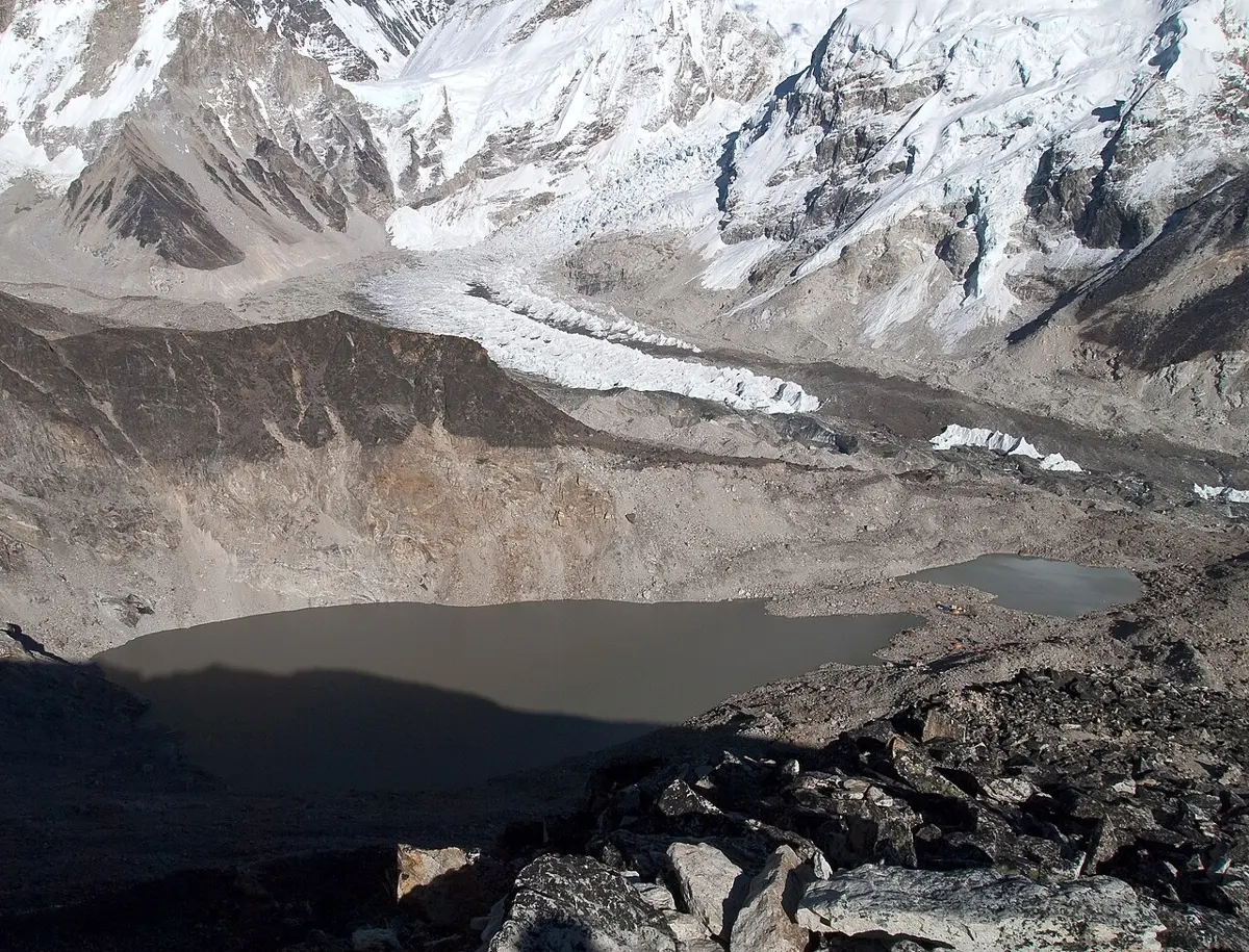
Runoff. Rain that doesn’t soak in runs over the ground, downhill, into streams and rivers. Nepal’s great rivers, the Koshi, the Gandaki and the Karnali, all flow south into the Ganga, and the Ganga flows into the Bay of Bengal, back where the water started.
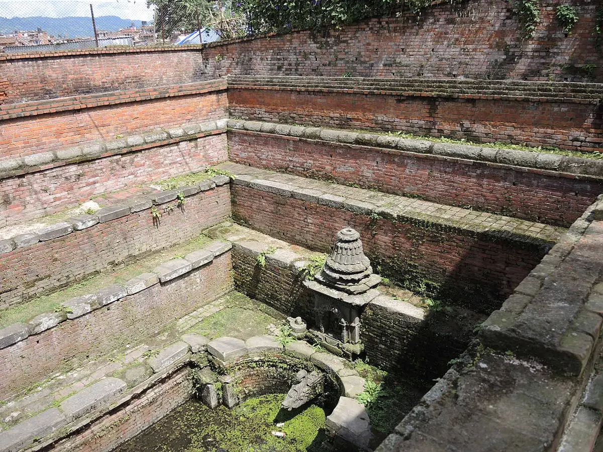
Infiltration and groundwater. Some rain soaks into the soil (infiltration) and seeps down into the cracks and spaces between grains of sand and rock. There it becomes groundwater, which moves very slowly downhill underground and comes out again in springs, wells and streams. Water may stay underground for months, or for thousands of years.
On a sunny morning, a puddle on the road gets smaller and then disappears. Where has the water gone?
Pick an answer to see why.
Which of these is not a change of state?
Pick an answer to see why.
Now follow one bit of water yourself. At each place, choose where it goes next.
The Sun lifts, gravity brings down
The water cycle never stops, so something must keep it going. Look at the arrows in Figure 25.1 again. They are of two kinds.
The Sun lifts water up. Turning liquid water into vapor takes a lot of energy: about 2,450 kJ for every kilogram of water, more than five times the energy needed to heat the same water from 0 °C to boiling. Almost all of it comes from sunlight. About half of the sunlight that the land and sea absorb goes into evaporating water. The Sun’s heat also drives the winds and the rising air that carry the vapor high up and far away (you saw rising air, the thermals, in Grade 8).
Gravity brings water down. Once the water is liquid or solid again, gravity pulls it down: raindrops and snowflakes fall, runoff and rivers flow downhill, water soaks down into the ground, and even glaciers creep down their valleys. A river never flows uphill.
So the water cycle is like a machine with two parts. The Sun’s energy lifts the water; gravity brings it back. The energy the Sun spent lifting water is what a hydropower station takes back as the water falls through its turbines, which is why hydroelectricity is really solar energy.
What makes a river flow from the mountains down to the sea?
Pick an answer to see why.
How a cloud is made
Take a cold bottle of water out of the fridge on a hot, sticky day. In a minute it is covered in drops of water. They didn’t leak out of the bottle: they came from the air. The air around the bottle was cooled, and cool air can’t hold as much water vapor as warm air, so some of the vapor condensed on the cold glass.
Warm air can hold much more vapor than cold air. This table gives the most vapor that one kilogram of air (about a cupboard full) can hold at sea level:
| Temperature | Most vapor 1 kg of air can hold |
|---|---|
| 0 °C | 3.8 g |
| 10 °C | 7.6 g |
| 20 °C | 14.7 g |
| 30 °C | 27.2 g |
Every 10 °C warmer, the air can hold about twice as much. Air usually holds less than its most. The vapor it holds, as a percentage of the most it could hold, is its relative humidity, the humidity in a weather report. Air at 30 °C holding 13.6 g of vapor per kilogram has a relative humidity of 13.6 ÷ 27.2 = 50 %. Cool that air, and its relative humidity rises, until at 100 % it can’t hold any more. The temperature at which that happens is the air’s dew point. Cool it further, and vapor condenses.
So how does air high above the ground cool? In Grade 8 you saw that air warmed by the ground rises. The higher it goes, the less air there is above it pressing down, so the rising air expands. Air that expands cools: dry air cools by about 10 °C for every kilometer it rises. Rising air with vapor in it soon cools to its dew point, and its vapor starts to condense. That height is the flat bottom of the cloud, the cloud base.
To condense, vapor needs something to condense on, like the cold bottle. In the air, it condenses on specks of dust, smoke and sea salt, far too small to see. Each cloud droplet is about 0.02 mm across, so small and light that the gentlest rising air holds it up. A raindrop is about 2 mm across: a hundred times wider, so it holds about a million times as much water. In a cloud, droplets bump together and join, or (high up, where it is below 0 °C) ice crystals grow at the droplets’ expense, until they are heavy enough to fall.
Why do drops of water form on the outside of a cold bottle on a hot day?
Pick an answer to see why.
Air masses, highs and lows
The weather is what the air is doing at one place and one time: its temperature, pressure, humidity, wind and precipitation. Why does it change from day to day?
Air over one region for a few days takes on that region’s character: hot or cold, wet or dry. A huge body of air, often over a thousand kilometers across, with much the same temperature and humidity all through it, is an air mass. Air masses don’t stay still: winds carry them across continents. When a new air mass arrives, the weather changes.
Nepal’s weather comes from two great air masses, and from storms that visit from the west:
| Season | The air | Where it comes from | The weather it brings |
|---|---|---|---|
| June to September | warm, very moist | over the Bay of Bengal and the Indian Ocean | the monsoon: heavy rain, clouds, high humidity |
| October to February | cool or cold, dry | over the land to the north and west | clear skies, cold nights, morning fog in the Terai |
| winter, now and then | moist air, carried in by passing storms | from the west, from as far away as the Mediterranean | “western disturbances”: rain, and snow in the mountains, most in western Nepal |
Between them, in spring (March to May), the ground heats up fast and strong thermals build afternoon thunderstorms, often with hail.
Winds blow because of differences in air pressure, the push of the air above pressing down. You saw this with the sea breeze in Grade 8 Grade 8: Sea breeze and land breeze: air over the warm land rises, the pressure there falls, and air flows in from where the pressure is higher. The same happens on a scale of thousands of kilometers.
- Where air is sinking, the pressure at the ground is high. Sinking air is squeezed and warms up, so its relative humidity falls and clouds dry up: a high usually brings dry, settled weather.
- Where air is rising, the pressure at the ground is low. Rising air cools, reaches its dew point, and makes clouds: a low usually brings clouds, wind and rain.
- Near the ground, wind blows from high pressure towards low. The bigger the difference in pressure over a distance, the stronger the wind.
The monsoon itself works like a giant sea breeze. In summer, the land of South Asia and the high Tibetan Plateau heat up far more than the Indian Ocean. Air rises over the hot land, and moist air from the ocean flows in to take its place, bringing rain. In winter the pattern reverses, and dry winds blow from the land out to sea. (Why some places in Nepal get much more of that rain than others is the next topic, Why Is Pokhara So Wet and Mustang So Dry?.)
A weather map shows a large area of low pressure over Nepal. What weather is most likely?
Pick an answer to see why.
When air masses meet
When a moving air mass runs into a different one, they don’t mix at once. Cold air is denser than warm air, so the two keep apart along a boundary called a front, and the warm air is always pushed up over the cold. Lifting the warm, moist air cools it, and makes clouds and rain along the front.
- At a cold front, cold air pushes in under warm air like a wedge and lifts it up steeply and fast. Tall thunderclouds grow, and there is a short burst of heavy rain and gusty wind. Afterwards it is cooler and drier, the wind changes direction, and the pressure rises.
- At a warm front, warm air slides slowly up over a wedge of cold air. The rising is gentle, so the clouds come in thin, high layers first, thickening and lowering for a day or so, with long, steady rain. Afterwards it is warmer and more humid.
Fronts are most common in the middle latitudes, in Europe, China and North America, where cold air from near the poles meets warm air from near the tropics. The western disturbances that bring Nepal’s winter rain and snow are lows of this middle-latitude kind, which travel east from far to the west.
A weather station stays in one place while air masses move past it. Its readings tell the story of what went by.
A weather station records a sudden drop in temperature, a burst of heavy rain, a gusty wind that changes direction, and then rising pressure and drier air, all within a few hours. What has passed over it?
Pick an answer to see why.
Measuring the weather
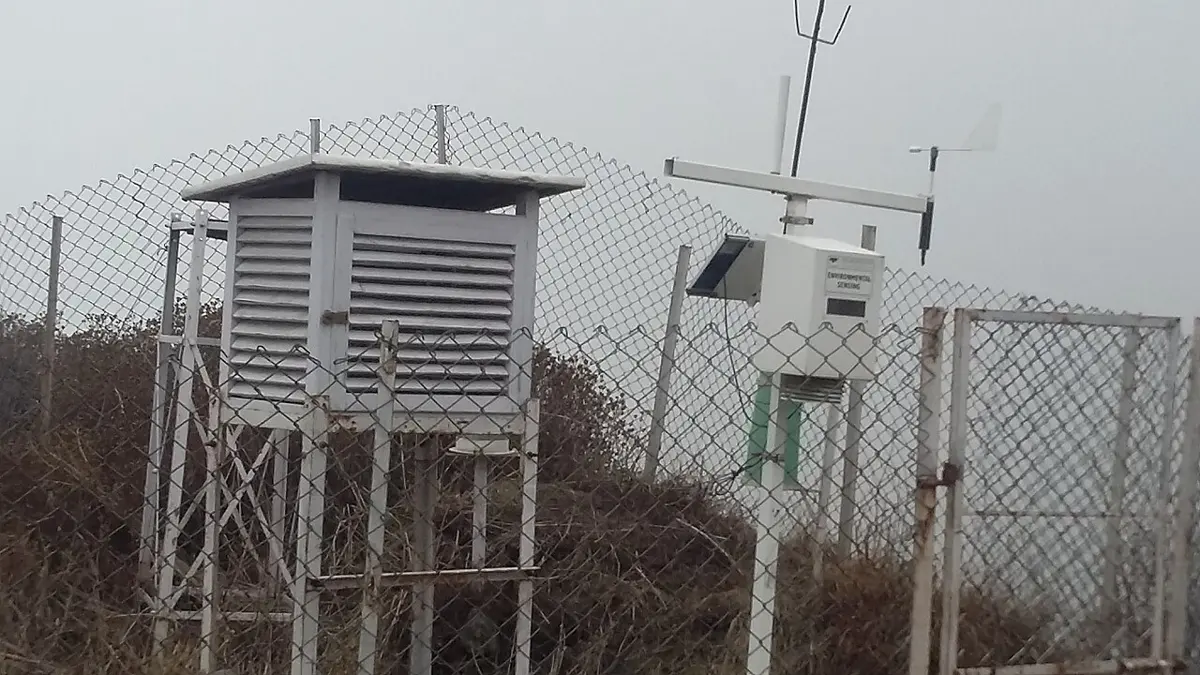
To know what air masses are doing, you have to measure them, at many places, at the same times, every day. Every weather station measures the same things in the same way, so that the readings can be compared:
| Quantity | Instrument | Unit |
|---|---|---|
| temperature | thermometer, in the shade | °C |
| air pressure | barometer | hectopascal (hPa); 1 hPa = 100 Pa |
| humidity | hygrometer | % |
| wind speed | anemometer (spinning cups) | km/h or m/s |
| wind direction | wind vane | the direction it blows from |
| rain or snow | rain gauge | mm (depth of water) |
The thermometer and hygrometer go inside a Stevenson screen, a white box with slatted sides, with the thermometers between 1.25 m and 2 m above short grass. It keeps the Sun off the thermometer but lets the air flow through, so it measures the air’s temperature, not the sunshine’s.
Air pressure at sea level is usually about 1,000–1,030 hPa, and changes by only a few hectopascals from day to day. Those few hectopascals matter: a falling barometer warns of a low coming, with cloud and rain; a rising one, of better weather. Pressure also falls as you go higher, so stations up in the hills, like Kathmandu at about 865 hPa, work out what their pressure would be at sea level, so that every station can be compared.
Forecasts are chances
Every day, millions of measurements are made around the world: by thousands of weather stations, by ships and aircraft, by satellites, and by weather balloons sent up once or twice a day from about 800 places. Powerful computers put them together into a picture of the whole atmosphere now, and then use the laws of physics to work out how the air will move, warm, cool and condense, step by step, hours and days ahead.
But the atmosphere is chaotic: a tiny difference now, too small to measure, grows into a big difference a week later. So forecasters run their computer models dozens of times, each starting from slightly different measurements. If 35 runs out of 50 give rain in Pokhara tomorrow, the forecast is a 70 % chance of rain.
A “70 % chance of rain” means: on days when the forecast says this, it rains at that place about 7 times out of 10. It doesn’t mean it will rain for 70 % of the day, or over 70 % of the area. And a 70 % forecast isn’t wrong when it stays dry: if it never stayed dry on those days, the forecast should have said more than 70 %.
Forecasts keep getting better: since the 1980s, they have gained roughly a day of accuracy every ten years, so a forecast for six days ahead is now about as good as one for five days ahead was ten years earlier. Beyond about two weeks, chaos wins: nobody can tell you if it will rain on a particular day a month from now. Forecasting the monsoon’s rain for a whole season is different: it is a forecast of the average over months, not of any one day, and it is given as chances too (“above normal rain more likely than below normal”).
The forecast for tomorrow says “80 % chance of rain”, and tomorrow stays dry. What can you say?
Pick an answer to see why.
Questions
Which path of the water cycle is powered by gravity?
Pick an answer to see why.
Early on a cold winter morning, Kathmandu is covered in fog, which clears by noon. Why does the fog clear?
Pick an answer to see why.
Weather station readings: the pressure has fallen slowly for a whole day, the clouds have become lower and thicker, and a steady rain has lasted for ten hours. Then the rain stops and it gets warmer. What has passed?
Pick an answer to see why.
Draw a model of the water cycle for a village in the hills of Nepal, with a spring, terraced fields, a forest and a river. Show at least six paths, name the change of state on each path where there is one, and mark each path S if the Sun’s energy drives it or G if gravity does.
Answer
A good model shows these paths (in any order) with arrows:
- Evaporation from the river, fields and wet ground into the air: liquid to gas (S).
- Transpiration from the forest and crops: liquid to gas (S).
- Air carrying the vapor rises over the hills and cools; condensation into clouds: gas to liquid (the rising is driven by the Sun’s heating, S).
- Precipitation as rain on the fields and forest, or as snow on the high peaks: (G); snow formed from vapor high up is gas to solid.
- Infiltration of rain into the soil, and seeping down to groundwater (G).
- Groundwater flowing underground and out at the spring (G).
- Runoff over the ground into the river, and the river flowing downhill to the sea (G).
- Snow melting on the peaks into streams: solid to liquid (S).
The model should show that the same water goes round and round: it is never used up, it just moves between stores.
Explain why Nepal’s rivers keep flowing in the dry months from October to May, when there is very little rain.
Answer
The water in the rivers in the dry months comes from stores that release it slowly. Groundwater, filled during the monsoon, keeps seeping out into springs and streams for months afterwards, because it moves very slowly through the ground. In the high mountains, snow and glaciers melt, especially in spring as the Sun gets stronger, and feed the rivers that start there. So the stores spread the monsoon’s rain out over the whole year.
Use the ideas of energy in this topic to explain why a hydropower station is really powered by the Sun.
Answer
The water turning the turbines has energy because it is high up: gravitational potential energy. It got up there because the Sun evaporated it from the sea, and its heat drove the winds and rising air that carried the vapor up over the mountains, where it fell as rain and snow. Gravity then brings it down through the turbines, which turn its energy into electricity. So the energy the station uses came from the Sun, lifting the water; without the Sun, no water would be raised, and the rivers would stop.
Air at 20 °C holds 7.6 g of water vapor per kilogram. Use the table in “How a cloud is made” to find (i) its relative humidity and (ii) its dew point. (iii) Would dew form on a car roof that cools to 5 °C during the night?
Answer
- i.Relative humidity = 7.6 g ÷ 14.7 g × 100 % ≈ 52 %.
- ii.7.6 g is the most air at 10 °C can hold, so the dew point is about 10 °C.
- iii.Yes. The air touching the roof is cooled to 5 °C, below its dew point of 10 °C, so vapor condenses on the roof as dew. (If the roof cooled below 0 °C, it would be frost instead.)
A weather station near Pokhara records these readings every six hours. When did a front pass? What kind of front was it? Give your evidence from the data.
| Time | Temperature | Pressure (at sea level) | Humidity | Wind from | Rain in last 6 h |
|---|---|---|---|---|---|
| Day 1, 06:00 | 24 °C | 1,008 hPa | 70 % | south | 0 mm |
| Day 1, 12:00 | 29 °C | 1,006 hPa | 60 % | south | 0 mm |
| Day 1, 18:00 | 27 °C | 1,004 hPa | 68 % | south | 0 mm |
| Day 2, 00:00 | 18 °C | 1,007 hPa | 95 % | north-west | 22 mm |
| Day 2, 06:00 | 14 °C | 1,011 hPa | 60 % | north-west | 1 mm |
| Day 2, 12:00 | 19 °C | 1,013 hPa | 45 % | north-west | 0 mm |
(The numbers are made up, as a station would record them.)
Answer
A cold front passed between 18:00 on Day 1 and 00:00 on Day 2. The evidence: the temperature dropped 9 °C in six hours, much more than evening cooling usually gives; 22 mm of rain fell in that time, a short heavy burst, then almost none; the wind changed from south to north-west; the pressure, which had been falling, started to rise; and after the rain the air was much drier (45 % by Day 2 noon) and stayed cooler, even at midday (19 °C against 29 °C the day before). A warm front would bring warmer air afterwards, after a long steady rain.
Two forecasters each forecast “60 % chance of rain” on 50 days. On those days, it rained 31 times for forecaster A, and 12 times for forecaster B. Which forecaster’s “60 %” can you trust more? Explain.
Answer
If “60 %” were right, it would rain on about 0.6 × 50 = 30 days. Forecaster A’s days had rain 31 times, very close to 30, so A’s forecasts can be trusted: when A says 60 %, it rains about 60 % of the time. Forecaster B’s had rain on only 12 days, 24 %, so B’s “60 %” really meant about 25 %: B forecast rain too often. (One day alone can never show this: you need many days.)
Where to go next
- Why Is Pokhara So Wet and Mustang So Dry? How global winds, ocean currents and mountains decide where the rain falls, and why the rain stops at the Himalaya.
- How Does One Rock Become Another? Rain, rivers and glaciers wear the mountains down and carry them to the sea: the water cycle at work on rock.
- Why Is It Cold in Winter? Why the Sun’s heat, the driver of the water cycle and the winds, changes with the seasons.