
Fly from Pokhara to Jomsom and the flight takes about 20 minutes. You take off from a green valley of rice terraces and thick forest, where farmers plant in the mud of a summer that rains almost every day. You fly up the Kali Gandaki between Dhaulagiri and Annapurna, two of the world’s highest mountains. And you land in a different world: bare brown cliffs, dust blowing along a stony riverbed, villages of flat-roofed houses, and apple orchards that grow only because farmers lead snowmelt to them in channels.
The two towns are only about 70 km apart. Yet Pokhara gets about 3,900 mm of rain in an average year, and Jomsom about 290 mm: thirteen times less. Jomsom gets less rain in a whole year than Pokhara gets in ten days of July. And there is a bigger puzzle behind this one. Nepal lies between about 26.4° and 30.4° north of the equator, the same distance from the equator as the Sahara Desert, the deserts of Arabia and the Thar Desert of Rajasthan. Cairo, in Egypt, is at 30° N; Kathmandu at 27.7° N. Why is Mustang a desert, and why isn’t the rest of Nepal one too?
To answer, you need a model of how the whole Earth’s air and oceans move, and why. You will build it in this topic, one piece at a time, and then use it to explain the climate of any place on Earth.
Two towns, 70 km apart
You met the difference between weather and climate in Grade 10 Grade 10: Weather and climate: weather is what the air is like on one day; climate is the average weather of a place over many years, usually 30. To compare two climates, scientists compare such averages. Here are Pokhara’s and Jomsom’s, month by month.
Two things stand out. First, Pokhara’s rain is not spread through the year: it comes in one great season, from June to September. Second, Jomsom hardly has a rainy season at all. The temperatures differ too: Pokhara averages about 21.5 °C over the year, Jomsom about 11.7 °C.
To understand both towns, we have to start far away from them: with the whole Earth, and the Sun.
The Sun heats the Earth unequally
You learned in Grade 6 that sunlight falling straight down heats the ground more than sunlight falling at a slant, because a slanting beam spreads the same light over more ground. (Why Is It Cold in Winter? shows this with a beam of sunlight you can tilt.) Near the equator, the noon Sun is high in the sky all year. Near the poles it is always low, and for months it doesn’t rise at all. So, averaged over a year, each square meter at the equator receives about 2.4 times as much sunlight as a square meter at the poles (measured at the top of the air, before clouds and ice reflect any of it).
If nothing moved the heat around, the tropics would get hotter and hotter and the poles colder and colder. They don’t, because the Earth has two great fluids that carry heat from the warm places to the cold ones: the air and the oceans. Their movements, the winds and the ocean currents, make the patterns of climate on Earth. Everything in this topic comes from two causes: the Sun heats the Earth unequally, and the Earth turns.
Averaged over a year, places near the equator get much more sunlight than places near the poles. Why don’t the tropics keep getting hotter, year after year?
Pick an answer to see why.
Rising air, sinking air
You know the start of this from Grade 8 Grade 8: Sea breeze and land breeze: where the ground is hot, the air above it is warmed, expands, becomes less dense and rises; cooler air flows in along the ground to take its place. A sea breeze is a small loop of moving air, a convection current, a few kilometers across. The Earth makes the same kind of loop on a giant scale.
Near the equator, the ground and the sea are hottest. Warm, moist air rises there, all the way round the Earth. Rising air cools, and as it cools its water vapor condenses into clouds and falls as rain (Grade 8’s Convection currents and weather; more in Where Does the Rain Come From?). So the equator has a belt of towering clouds and heavy rain almost every afternoon, and the world’s great rainforests grow there: the Amazon, the Congo, the islands of Indonesia.
The rising air can’t go up for ever. About 15 km up it spreads out north and south, high above the ground, towards the poles. On the way it cools, becomes denser, and around 30° north and south of the equator it sinks back to the ground. Sinking air is squeezed as it comes down, and warms up, so no clouds can form in it. Under it, the sky is clear almost every day, and rain is rare. That is why most of the world’s great hot deserts lie near 30° N and 30° S: the Sahara, the Arabian Desert, the Thar, the deserts of Australia and the Kalahari. From there the air flows back along the ground towards the equator, and the loop is closed.
This loop is called a Hadley cell, and there is one on each side of the equator. Farther towards each pole there are two more loops: a Ferrel cell, between about 30° and 60°, and a polar cell, from about 60° to the pole. The air rises again near 60°, where cold polar air meets warmer air and storms form (the stormy belt that brings Britain and Norway so much rain), and sinks again at the poles, which are deserts of ice: Antarctica gets less snow in a year, as water, than Jomsom gets rain.
Now look at Nepal on Figure 26.2. It is at 28° N, right in the belt of sinking air, of deserts. By this part of the model, all of Nepal should be as dry as Rajasthan. Something else must be at work, and it is: but first, look at the arrows on the Earth’s face. The winds at the ground don’t blow straight north or south. They blow at a slant.
The Sahara and the Arabian Desert lie near 30° N. What makes that latitude so dry?
Pick an answer to see why.
Why the winds bend
If the Earth didn’t turn, the air returning to the equator along the ground would blow straight from the north in the northern half of the Earth, and straight from the south in the southern half. But sailors have known for centuries that the steady winds of the tropics, the trade winds, blow from the north-east north of the equator, and from the south-east south of it. Something bends them. It is the Earth turning under them.
Try it with the widget. A pen is pulled straight along a ruler, held still above a disc, from the middle out to the edge. Turn the disc, and watch the line the pen leaves on it.
The pen goes straight, but the line on the disc curves. Someone riding the disc doesn’t feel it turn; to them, it looks as if something pushed the pen sideways. We all ride the turning Earth. So to us, anything that moves a long way over the Earth, a wind or an ocean current, seems to swerve: to the right in the northern half of the Earth, and to the left in the southern half. This swerve is called the Coriolis effect, after the French engineer Gaspard-Gustave de Coriolis, who worked out the mathematics of it in 1835.
There is a simple way to see why air from the north swerves to the west. The Earth turns once a day, so every place on it is carried round towards the east. A place on the equator goes all the way round, 40,075 km, in 24 hours. A place nearer the pole goes round a smaller circle in the same time, so it moves more slowly.
Now think of air flowing south, from 30° N towards the equator. It starts out moving east with the slower ground of 30° N. As it comes south, the ground beneath it is moving east faster and faster. The air falls behind: it drifts westwards over the ground. Moving south and drifting west, it blows from the north-east: the north-east trade winds. (Real winds don’t keep their speed perfectly, because they rub against the ground, but the direction of the swerve is right.) In the same way, air moving towards the poles drifts east, which is why the winds between 30° and 60° blow mostly from the west: the westerlies.
These steady wind belts are the prevailing winds: the winds that blow most often at a place. In Figure 26.2: the trade winds near the tropics, the westerlies in the middle latitudes, and the polar easterlies near the poles.
Air near the equator flows south, from 10° N towards the equator, at the Earth’s surface. Which way does the wind seem to blow, to someone on the ground?
Pick an answer to see why.
Rivers in the sea
The winds don’t only move air. As they blow across the ocean, they drag its surface water along with them, and over thousands of kilometers they set whole oceans moving. These great flows of sea water are ocean currents. Like the winds, they are bent by the Earth’s turning; and unlike the winds, they can’t cross the land, so the continents turn them. In each great ocean, the currents go round in a huge loop, called a gyre: clockwise in the northern half of the Earth, anticlockwise in the southern half.
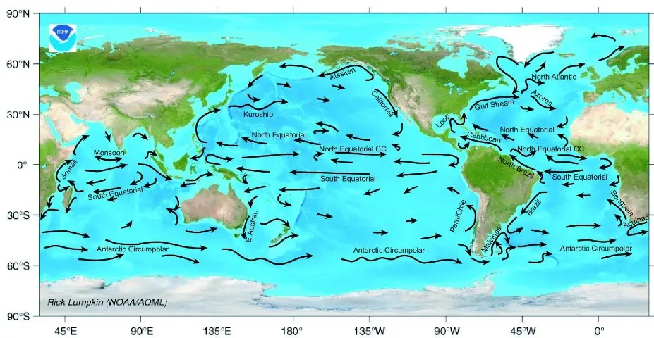
The currents carry heat the way the winds do. Warm water from the tropics flows towards the poles, usually along the eastern coasts of the continents, and cold water comes back towards the equator along the western coasts. The most famous warm current is the Gulf Stream, which flows from the Gulf of Mexico up the coast of North America and across the Atlantic towards Europe. Off Florida it carries about 25 times as much water as all the world’s rivers together, and farther north, where more water has joined it, over 100 times.
Cold currents do the opposite. Off the west coast of South America, the cold Humboldt Current flows north from near Antarctica. It cools the air above it from below, and cool air under warmer air can’t rise to make rain clouds. Together with the sinking air of the subtropics and the shelter of the Andes Mountains, it makes the Atacama Desert of Chile one of the driest places on Earth: some places in it get a few millimeters of rain a year at most, and have gone years without any. The Namib Desert, on the cold west coast of southern Africa, is a desert for the same reasons.
The slow conveyor belt in the deep
There is a second, slower kind of ocean current, deep down. In the far North Atlantic, near Greenland, and around Antarctica, the sea water gets very cold, and when sea ice freezes it leaves most of its salt behind in the water around it. Cold, salty water is dense, so it sinks to the ocean floor, and creeps along the bottom towards the equator and into the other oceans. Far away, it slowly rises again and flows back near the surface to replace the water that sank. This worldwide loop is called the global ocean conveyor belt. It is another convection current, like the air’s, driven by water that is cold and dense in one place and warmer in another. It is very slow: a drop of water takes about 1,000 years to go all the way round.
Two towns are at the same latitude, both on the coast. Town A has a warm current along its coast and town B a cold one. Which is likely to have more rain?
Pick an answer to see why.
The monsoon: a sea breeze the size of a continent
Now we can come back to Nepal, and the question of why it isn’t a desert.
Remember the sea breeze. By day, land heats up faster than the sea, because water has a much higher specific heat capacity; air rises over the warm land, and cooler, moist air flows in from the sea. By night it turns round. Now make the land the whole of South Asia, and the sea the Indian Ocean, and instead of day and night, think of summer and winter.
In April and May the land of South Asia heats up much faster than the ocean: the plains of northern India and Pakistan reach over 45 °C, and the high Tibetan Plateau, about 4,500 m up, heats the air above it too. Hot air rises over the land, leaving low pressure, and from June the moist air over the warm Indian Ocean flows in to replace it, across thousands of kilometers. As this sea air reaches the land and is pushed up, over hills and over the land’s own rising air, it drops its water as rain. In winter the land becomes colder than the sea, and the flow turns round: cool, dry air flows out from the land towards the sea, and the rains stop. This great seasonal wind is the monsoon. The word comes from the Arabic mawsim, “season”.
The sea breeze is not the whole story: the rainy belt of rising air near the equator, in Figure 26.2, moves north and south a little with the Sun through the year, and over South Asia in summer it is pulled far north, over the hot land. That is why the monsoon overpowers the dry, sinking air that makes deserts at the same latitude elsewhere.
The monsoon’s air reaches Nepal by an unexpected road. Part of it comes across the Arabian Sea from the south-west; part crosses the Bay of Bengal, and there, blocked by the Himalaya and pulled by the low pressure over north India, it turns and flows west along the mountains. So the monsoon reaches Nepal from the east and south-east, not the south-west. It arrives first in eastern Nepal, usually around 13 June, and leaves around 2 October, the average dates measured by the Department of Hydrology and Meteorology. In those four months, Nepal gets about four-fifths of its whole year’s rain.
Why does the summer monsoon bring rain to Nepal, though it is at the latitude of the world’s deserts?
Pick an answer to see why.
The rain shadow
So the monsoon brings the rain. Why does it fall on Pokhara, but not on Jomsom?
When moist monsoon air reaches the foothills, it can only go one way: up. Rising air cools, as you saw in Grade 8 (it has less air pressing on it, so it expands, and expanding air cools), and once it has cooled enough its water vapor condenses into cloud and falls as rain. The steeper and higher the slopes, the more rain is squeezed out. Pokhara sits at the foot of the Annapurna range, about 40 km from peaks over 7,000 m, and the hills just north of it are among the wettest places in Nepal: Lumle, at 1,738 m, about 20 km north-west of Pokhara, averages about 5,500 mm of rain a year.
By the time the air has climbed over the Himalaya, it has lost much of its water. And as it sinks down the far side, it is squeezed and warms up, so its humidity falls and no clouds can form. The land on the far side of a mountain range, sheltered from the wet winds, is in a rain shadow. Mustang lies just north of the main Himalayan range, in its rain shadow, and so does the whole Tibetan Plateau beyond it.
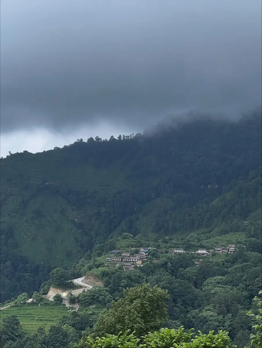
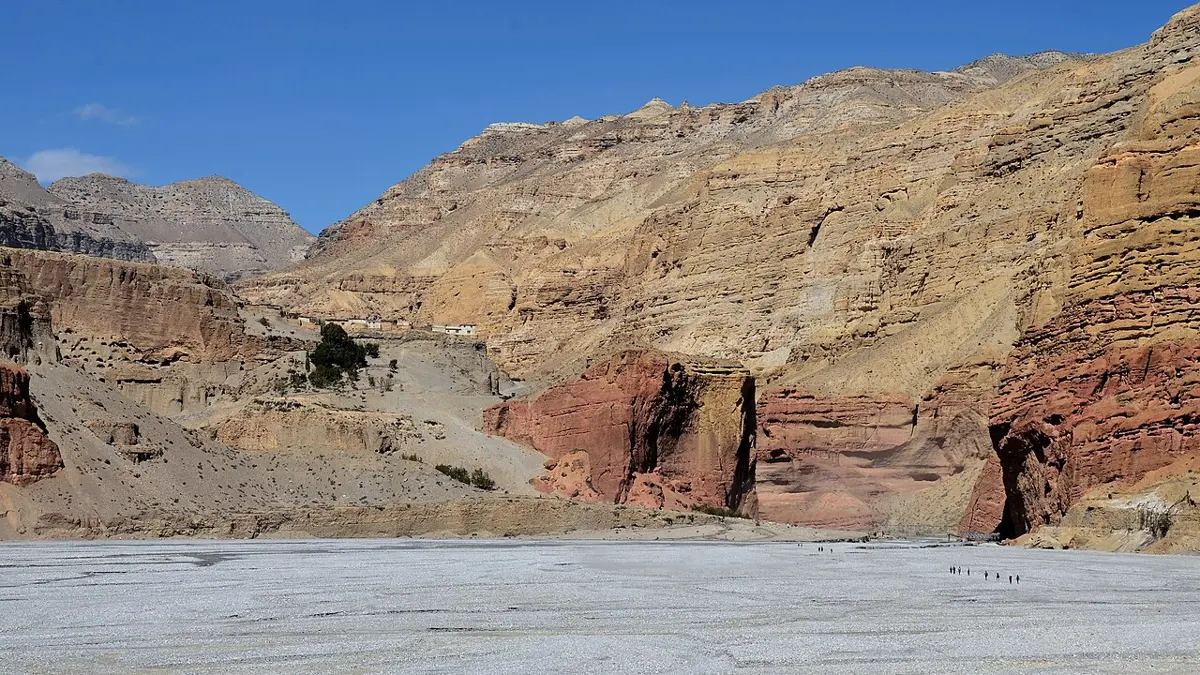
From space, the rain shadow is easy to see.
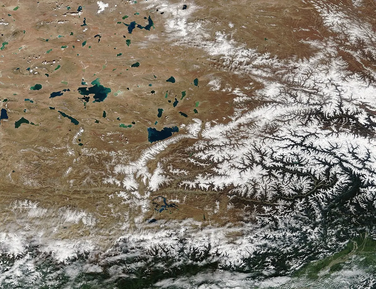
Mustang’s little rain doesn’t all come in the monsoon. A few times each winter and spring, storms traveling east from the Mediterranean and the Middle East, called western disturbances (lows, areas of low pressure: see Where Does the Rain Come From?), bring snow to Mustang and western Nepal. That is why, in Figure 26.1, Jomsom gets almost as much rain and snow in March as in June.
A mountain range runs north–south, and the prevailing winds blow from the west, off the ocean. Where would you expect the driest land?
Pick an answer to see why.
Higher is colder
There is one more reason Jomsom differs from Pokhara: it is almost 2 km higher, and higher places are colder. You know this from any trip into the hills: Nagarkot is cooler than Bhaktapur below it, and snow lies on the mountains long after it has melted in the valleys.
The air is warmed mostly from below, by the ground, which absorbs sunlight. And air that rises has less air pressing on it, so it expands and cools. So, on average, the air gets colder the higher you go, by about 6.5 °C for every kilometer of height, though the real figure changes from place to place and season to season. (A bubble of air rising through it cools faster, about 10 °C per kilometer until clouds form in it, as Where Does the Rain Come From? shows; 6.5 °C per kilometer is how the air around it changes with height.)
Putting the model together
You now have a model that can explain the climate of almost any place. It has two causes, unequal heating and the Earth’s turning, and these effects:
- a.Latitude: the nearer the equator, the more sunlight. The belts of rising air (rainy: near the equator and 60°) and sinking air (dry: near 30° and the poles).
- b.Prevailing winds, bent by the Earth’s turning: whether the wind comes off a warm ocean, a cold ocean or a dry continent.
- c.Ocean currents: warm currents warm and wet the coasts they pass; cold currents cool and dry them.
- d.Land and sea: land heats and cools much faster than the sea, which makes monsoons, and makes places far inland hotter in summer and colder in winter than places on the coast.
- e.Mountains: rain on the slopes facing the wind, a rain shadow behind.
- f.Altitude: about 6.5 °C colder for every kilometer up.
| Place | Its climate | The main reasons |
|---|---|---|
| Pokhara | warm, very wet summers, dry winters | monsoon air from the Bay of Bengal, pushed up the Annapurna range |
| Jomsom | cool, dry all year | in the Himalaya’s rain shadow; nearly 2 km higher |
| The Sahara | hot, very dry | sinking air near 30° N |
| The Congo rainforest | hot, wet all year | rising air near the equator |
| London | mild, damp | westerly winds off an ocean warmed by the North Atlantic Current |
| The Atacama | cool for a desert, almost rainless | cold Humboldt Current, sinking air, the Andes’ rain shadow |
| Mawsynram, India | wettest place on Earth | monsoon air forced up steep hills |
Questions
Which of these places is most likely to be a desert?
Pick an answer to see why.
In the southern half of the Earth, which way do the trade winds blow?
Pick an answer to see why.
Use the model in this topic to explain why the Sahara is a desert and the Congo, about 20° to the south of it, is a rainforest.
Answer
The Congo is on the equator, where the Sun heats the Earth most. Warm, moist air rises there, cools as it rises, and its water vapor condenses into clouds and falls as rain, almost every day, so a rainforest grows. The air that rose spreads out high up towards the poles and sinks again near 30° N and S. Sinking air is squeezed and warms up, so clouds can’t form and rain is rare. The Sahara lies under this sinking air, near 30° N, so it is a desert.
Pokhara and Jomsom are about 70 km apart. Give three reasons, from this topic, why their climates are so different.
Answer
- a.Rain shadow: the monsoon air comes from the south. It is pushed up the Annapurna range above Pokhara, cools, and drops much of its water as rain on the south side. Jomsom lies north of the main range; the air that reaches it has lost much of its water and warms as it sinks, so it brings little rain.
- b.Height: Jomsom is about 1.9 km higher than Pokhara, and air is colder higher up (by about 5 °C per km between these two towns), so Jomsom is about 10 °C colder on average.
- c.When the rain comes: Pokhara’s rain comes mostly in the monsoon (79% from June to September), which hardly reaches Jomsom; much of Jomsom’s small rain and snow instead comes in winter and spring, from western disturbances.
Draw a mountain range with the wind blowing over it from the left. Mark where clouds form, where the rain falls, and the rain shadow. Explain each part of your drawing.
Answer
Your drawing should show: the wind arriving from the left at the foot of the range; the air rising up the left (windward) slope; clouds forming partway up the slope, where the rising air has cooled enough for its water vapor to condense; rain falling on the upper windward slope; the air passing over the top and sinking down the right-hand (leeward) side; and a dry area on the right, the rain shadow. Rising air expands and cools, so it can hold less water vapor and the rest condenses and falls; sinking air is squeezed and warms, so it can hold more water vapor than it has, and no clouds form.
In Jomsom, January to March bring 66 mm of rain and snow, more than a fifth of its year’s total. In Pokhara, the same months bring 120 mm, about 3% of its year. Why is the winter share so much larger in Jomsom?
Answer
Pokhara gets enormous amounts of rain in the monsoon, so its winter rain, though more than Jomsom’s, is only a small share of its year. Jomsom is in the Himalaya’s rain shadow, so the monsoon gives it little. Its winter and spring snow comes from western disturbances, storms that travel from the west, which the rain shadow of the southern slopes doesn’t block. So those months make a much bigger share of Jomsom’s small total.
Off the coast of Peru, the sea water is cold even though the coast is in the tropics. Explain where the cold water comes from, and why the coast nearby is a desert.
Answer
The Humboldt Current flows north along the west coast of South America, bringing cold water from the far south, near Antarctica. (On the western coasts of the continents, the ocean’s great loops carry cold water towards the equator.) The cold sea cools the air above it from below. Cool air under warmer air is stable: it doesn’t rise, so it doesn’t form rain clouds. Together with the dry, sinking air of the subtropics and the Andes Mountains blocking moist air from the east, this makes the coast a desert, the Atacama.
The monsoon usually reaches eastern Nepal several days before western Nepal, and eastern Nepal gets more rain. Use the path of the monsoon winds to explain why.
Answer
Most of Nepal’s monsoon air comes from the Bay of Bengal, to the south-east. Blocked by the Himalaya and pulled towards the low pressure over north India, it turns and flows west along the mountains. So it reaches eastern Nepal first, and as it travels west it keeps dropping rain on the hills, so less water is left in the air by the time it reaches the far west.
Imagine the Earth stopped turning, but the Sun kept heating it as now. What would happen to the trade winds?
Answer
With no turning, there would be no Coriolis effect, so the winds wouldn’t swerve. Air would still rise at the hot equator and flow back to it along the ground, but it would blow straight from the north in the northern half and straight from the south in the southern half, instead of from the north-east and south-east. (The day would also last a year, so the side facing the Sun would become very hot and the other side very cold, and the winds would change completely: but the swerve, at least, would be gone.)
Explain why a town on an island in the middle of an ocean has a smaller difference between summer and winter temperatures than a town in the middle of a continent at the same latitude.
Answer
Water has a much higher specific heat capacity than rock and soil, and the sea mixes its heat down to a great depth. So the sea warms up slowly in summer and cools slowly in winter, and the air over it stays mild. The island town gets its air from the sea, so its summers are cooler and its winters milder. The town in the middle of the continent is surrounded by land, which heats up quickly in summer and cools quickly in winter, so its summers are hotter and its winters colder.
Where to go next
- Where Does the Rain Come From? How water evaporates, condenses into clouds and falls, and how air masses meeting change the weather from day to day.
- Why Is It Cold in Winter? The tilt of the Earth, the height of the Sun and the length of the day, which move the belts of this topic north and south through the year.
- Is the Earth Really Getting Warmer? The evidence that the climate this topic explains is changing, and why.