
On 10 January 1992 a container ship on its way from Hong Kong to Tacoma, in the United States, ran into a storm in the North Pacific near the International Date Line. A dozen containers went over the side. One of them held about 29,000 bath toys: yellow ducks, red beavers, blue turtles and green frogs, each in a plastic shell glued to a card. Seawater dissolves that glue within a day, so the toys soon floated free.
On 16 November that year a beachcomber near Sitka, in Alaska, found six of them. Over the next nine months about 400 more turned up along 850 km of the Gulf of Alaska’s shore, and two oceanographers in Seattle, Curtis Ebbesmeyer and James Ingraham, collected the reports. Ingraham ran a computer model of the winds and the currents they drive across the North Pacific. The toys gave it a known start and hundreds of known ends. Toys stand high in the water and catch the wind, so the model had to be adjusted until its drift reached Sitka on the right day, and then it could be run on to show where the rest were going. From the toys and other things lost at sea, sneakers, beer bottles with messages, even pumice from an Alaskan volcano, they worked out that something floating in that part of the Pacific goes round once in about three years, at 11 to 13 cm a second, a fifth of a swimmer’s pace. They also expected some toys to slip north through the Bering Strait, freeze into the Arctic ice and come out years later in the Atlantic. Toys have been found on Atlantic shores since, but nobody has proved that any of them came from that container.
So the sea isn’t a still pool. It moves, in great slow loops, and what it carries is mostly not ducks but heat. That is why the ocean matters even to a country with no coast.
Rivers in the sea
The sea moves in three ways at once. Currents carry water across whole oceans. Tides lift and lower it twice a day. Waves, made by the wind, run across its surface and break on the coasts.
The surface currents are driven by the wind. Steady winds blow over the oceans, from the east near the equator and from the west farther north and south (where those winds come from belongs to the chapter on air). Wind dragging over water pushes it along. North of the equator the Earth’s spin bends anything moving over it to the right, and south of the equator to the left, so the water doesn’t simply follow the wind. The continents stand in the way, too. Put the push, the bend and the walls together and each ocean’s surface turns in a giant loop, called a gyre. There are five great ones: in the North and South Atlantic, the North and South Pacific, and the Indian Ocean. On the western side of each ocean the loop is squeezed into a fast, narrow current. On the eastern side it is broad and slow.
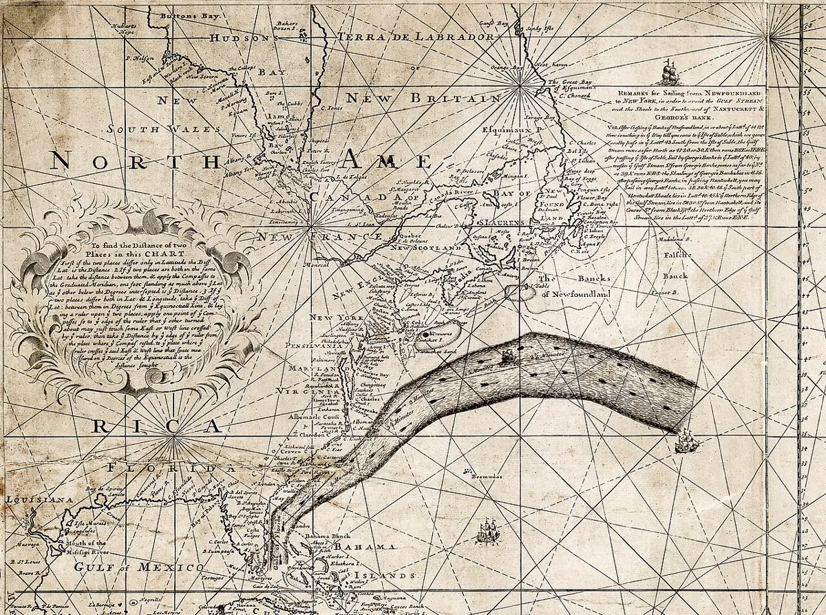
The most famous of the fast ones is the Gulf Stream. It comes out of the Gulf of Mexico through the Straits of Florida, runs up the coast of the United States and turns out across the Atlantic. It averages about 6 km an hour and reaches about 9 km an hour near its surface, and it carries more water than all the rivers on Earth put together. Its partner in the Pacific, running north past Japan, is the Kuroshio.
Sailors knew the Gulf Stream long before scientists did. In 1768 Benjamin Franklin, who was then in London running the mail service for Britain’s American colonies, was asked a puzzling question. Why did the mail ships from Falmouth to New York take about a fortnight longer than merchant ships sailing from London to Rhode Island, close by? He asked his cousin Timothy Folger, a whaling captain from the island of Nantucket. The whalers knew the current well, Folger said, because whales keep to its edges, and they had often crossed it and met the mail ships in the middle of it, sailing straight into a current that was against them “to the value of three miles an hour.” The whalers had told them so. But, as Franklin wrote down Folger’s words, the mail captains “were too wise to be counselled by simple American fishermen.” With light winds they were carried backward. Folger drew the current on a chart, Franklin had it printed in 1769, and the mail captains, Franklin noted, ignored it.
Where the wind pushes surface water away from a coast, colder water rises from below to take its place. That rising is called upwelling, and the deep water it brings is full of nutrients, food for the tiny plants that feed everything else in the sea. So the world’s great fishing grounds lie where upwelling is common, such as the Pacific coasts of the Americas, off Peru and California.
Every few years, off Peru, the upwelling weakens or stops. The winds along the equator slacken, warm water spreads back east across the Pacific, and the fish go hungry. Fishermen in South America noticed these spells of warm water in the 1600s and called them El Niño de Navidad, the Christmas boy, because they peak around December. Scientists now know that El Niño changes weather over much of the world, and its link to the monsoon over South Asia is real but unreliable. In 2002, during a weak to moderate El Niño, India had one of its driest monsoons. In 1997, during the strongest El Niño of the century, it had more rain than usual.
Below the wind-driven surface there is a second, much slower circulation. Near Greenland and around Antarctica the sea freezes, and when seawater freezes the salt stays behind in the water left over. That water is now cold and salty, so it is heavy, and it sinks to the bottom and spreads slowly through the deep oceans, while surface water flows in to take its place. The whole loop, through all the oceans, is reckoned to take about a thousand years.
The tides
Spend a day on a beach and the sea comes up the sand and goes back down twice. In Nepali the rise and fall are ज्वारभाटा (jvārbhāṭā), ज्वार (high tide) and भाटा (low tide).
The tides are made mostly by the Moon. Its pull is a little stronger on the side of the Earth facing it than at the Earth’s middle, and a little weaker on the far side. So the water facing the Moon is pulled toward it into a low bulge, and on the far side the water, pulled least, is left behind as a second bulge. The Earth turns under the two bulges, and a beach passes through both of them each time it goes round. The Moon moves on a little along its orbit while the Earth turns, so it takes 24 hours and 50 minutes for a place to come back under the Moon, and high tides come 12 hours and 25 minutes apart, about 50 minutes later each day. The Sun raises tides too, about half as large as the Moon’s. At new moon and full moon, औँसी and पूर्णिमा, the Sun and the Moon pull in line and the tides are biggest: these are called spring tides, though they have nothing to do with spring. A week later, when the two pull at right angles, come the smaller neap tides. The pull itself is explained in Grade 10’s Motion and Force, which also points out that the solid ground under Bhaktapur rises and falls with the Moon too, by too little for anyone to notice.
How big the tide is at a place depends above all on the shape of its coast. The largest in the world are in the Bay of Fundy, in eastern Canada, a long funnel of a bay. The bay and the Gulf of Maine outside it, taken together, would slosh back and forth by themselves about once every 13 hours, close to the 12½ hours between one high tide and the next, so each tide pushes the water higher, like a child on a swing pushed at the right moment. At Burntcoat Head the sea rises and falls by around 16 m, as much as a five-story building. Leaf Basin, in Canada’s far north, claims the record as well, and Canada’s hydrographers call the two statistically tied.
Waves and the coast
Waves are made by the wind rubbing on the water. How big they grow depends on three things together: how hard the wind blows, how long it keeps blowing and how far it blows over open water, which sailors call the fetch. A strong gust for a few minutes makes no big waves, and neither does a gale across a small lake. A storm blowing for days across a whole ocean does.
The water in a wave doesn’t travel with it. Each bit of water goes round in a circle and comes back to about where it started, and only the energy moves on, sometimes across an entire ocean. That changes when a wave reaches shallow water. Its bottom drags on the sea floor, its top runs ahead, it grows steeper, and it breaks.
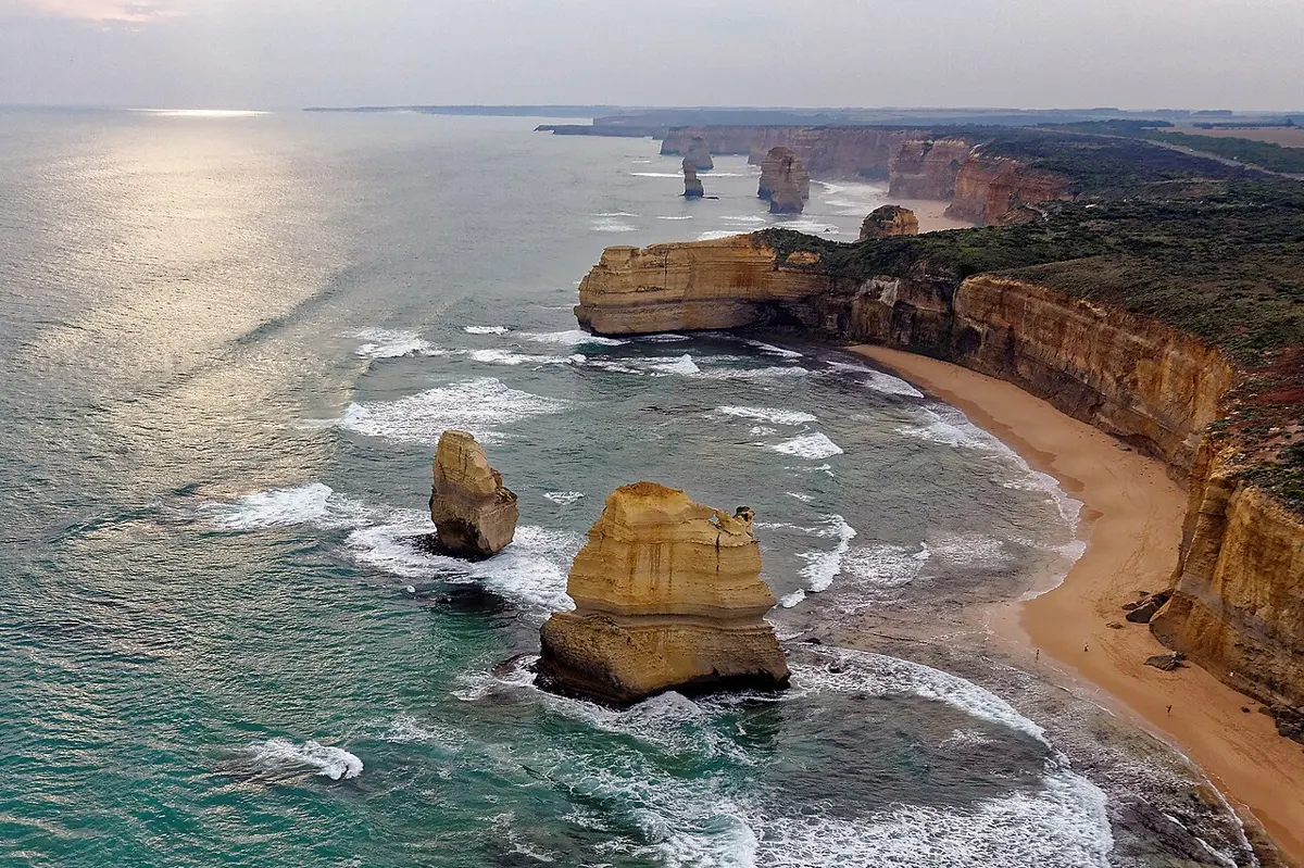
Breaking waves are what shape coasts. Where a coast is rock, they hurl water and stones at it, and they find its weaknesses. Hard rock stands out as headlands and soft rock is cut back into bays. Waves work at a crack in a headland until it becomes a cave, the cave runs right through into an arch, and when the arch falls, the sea is left with a tall pillar of rock standing on its own, a stack. On the coast of Victoria in Australia, a double arch called London Bridge lost its span nearest the shore in 1990, leaving two visitors stranded on the far part until a helicopter lifted them off. Along the same coast stand the limestone stacks called the Twelve Apostles, and the waves are still at work on them, and on the headlands behind, which are on their way to becoming new ones.
Where the coast is soft, the sea takes land fast. The cliffs of Holderness, in eastern England, are made of clay left by the ice age, and they lose on average a meter or two a year. Villages that once stood on them are now under the sea.
What waves take from one place they leave in another. Waves usually reach a beach at a slight angle, so each one pushes sand a little way along the shore before the water runs back, and over time sand and pebbles travel along the coast. This is longshore drift. Where the coast turns a corner, the drift carries on into open water and builds a long, narrow tongue of sand called a spit. Sand and shingle from Holderness’s cliffs end up partly at Spurn, a spit about 5½ km long reaching across the mouth of the Humber. The same pushing makes rip currents, narrow streams of water rushing straight out from a beach. They can move faster than an Olympic swimmer and sweep even a strong one out to sea. Someone caught in one should swim along the shore, not against it, since a rip is seldom more than about 25 m wide.
Not every big wave is made by wind. When an earthquake or a landslide under the sea suddenly lifts or drops the sea floor, it sets off a tsunami, a few very long waves that can cross a whole ocean and come ashore not as breakers but as the sea rising and rushing inland. Tsunamis have nothing to do with tides, though people sometimes call them tidal waves. On 26 December 2004 a magnitude 9.1 earthquake off Sumatra sent a tsunami across the Indian Ocean, and it killed about 228,000 people around the Indian Ocean.
The sea’s store of heat
Water is slow to warm up and slow to cool down. It takes more heat to warm a kilogram of water by a degree than a kilogram of dry soil, and about nine times as much as a kilogram of iron (Grade 10 Science measures it). And the sea is fluid. Sunshine on land heats only a thin skin of ground, which gets hot by afternoon and cold by night. Sunshine on the sea is mixed down through meters of water, so a much greater mass shares the heat and none of it gets very hot. Put together, the top two meters of the ocean hold about as much heat as the whole of the air above them. Of the extra heat the Earth has gained as the climate has warmed over the past century, about 90% has gone into the sea.
So the ocean works like a giant hot-water bottle. It soaks up heat in summer and gives it back in winter, and it barely notices the difference between day and night. The air over it takes on its steadiness, and where that air blows onto land it brings the steadiness ashore. That’s why places by the sea have mild winters, cool summers and small swings of temperature, and places far inland have big ones.
Western Europe shows it most clearly, because its winds come off the Atlantic. Valentia, on the west coast of Ireland, averages about 7 °C in January and 15 °C in July, a swing of only 8 degrees through the year. Kyiv, at about the same latitude but deep in the continent, averages about −3 °C in January and 21 °C in July, a swing of 24 degrees. Both are low-lying.
The Gulf Stream is often given the credit for Europe’s mild winters, and NOAA’s own pages say it warms western Europe. How big a share it brings is argued, though. In 2002 Richard Seager and his colleagues worked out why western Europe’s winters are so much milder than those across the Atlantic at the same latitude. About half the difference, they found, is summer heat the Atlantic stores and gives back in winter, carried ashore by the westerly winds. The other half is the way those winds bend after crossing the Rocky Mountains, bringing cold air down into eastern North America and warm air up into Europe. The current itself, on their reckoning, adds only a few degrees. Others give it a bigger part, and the argument isn’t settled. Either way, it is the ocean, by its store of heat or by its currents, that keeps Ireland mild.
Nepal sits in the middle of this story. Biratnagar, in the eastern Terai, is at almost exactly the same latitude as Naha, on the island of Okinawa in Japan, with the sea all round it. Both are near sea level, and over a whole year they’re about equally warm. But look at a single day. On a normal January day in Naha the temperature goes from about 15 °C at night to 20 °C in the afternoon, a swing of 5 degrees. In Biratnagar it goes from 9 °C to 22 °C, a swing of 13. In Kathmandu, higher up, the January night falls to about 3 °C and the afternoon reaches 19 °C, a swing of 16 degrees, which is why a winter morning in the Valley is near freezing and the afternoon warm enough to sit in the sun. The land’s thin, quickly heated skin is most of the answer. Clear, dry winter skies probably add to it, letting the day’s heat escape fast after dark, though that last part is our own reading rather than a measured one.
Through the year the difference is smaller than you might expect. Nepal’s summer heat is cut short in June by the monsoon’s cloud and rain, so Biratnagar’s year swings only a little more than Naha’s.
Far from the sea, and close to it
Nepal has no coast. Its nearest point to the sea, in the southeast corner of Jhapa, is about 450 km from the open Bay of Bengal. Kathmandu is about 650 to 700 km from it, depending on where in the wide river mouths you decide the sea begins, and Mahendranagar, in the far west, is more than 1,000 km from the Arabian Sea. That is far enough for the sea’s steadying hand to be lost. But it isn’t very far, as continents go. The place on Earth farthest from any sea, in the Dzungarian desert of northwest China, is about 2,500 km from the nearest coast, in a desert. Earth’s Extremes has it, with the point in the ocean farthest from any land.
Nepal is close enough for the sea to reach it every summer. The water that falls on Nepal in the monsoon was lifted out of the warm Indian Ocean and the Bay of Bengal and carried north by the wind. The sea’s slowness is part of that story too: in spring the land warms faster than the deep ocean, and that helps the rain belt travel far north over the continent.
And Nepal sends something back. Its rivers, the Koshi, the Gandaki and the Karnali, flow into the Ganges, which joins the Brahmaputra and reaches the Bay of Bengal through a vast delta built of mud carried down from the Himalaya. Some of that mud began as rock in Nepal’s hills. On the delta’s edge, where the river water meets the tide, grows the Sundarbans, which UNESCO counts as the largest mangrove forest in the world: about 10,000 km² of trees on stilt roots and tidal channels, home to Bengal tigers. Nepal’s own coast, in a way, is there: a forest growing on what its mountains have given to the sea.
Found a mistake? Please tell us.