
On 18 August 2008 the Koshi broke out of its bed. It happened at Kusaha in Sunsari, in Nepal, 12 km upstream of the barrage that controls the river. For half a century two long earth banks had held the Koshi in a corridor on its way to India. That day the eastern bank gave way, and most of the river, 80 to 85 percent of its water, poured through the gap and away to the south.
It didn’t spread out at random. It found a channel the Koshi had used long before and ran down it as a sheet of water 15 to 20 km wide and 150 km long, across fields and villages in Bihar that people had thought safe from floods. Tens of thousands of people lost their homes in Nepal, and millions were caught by the water in India. Official records count 493 dead and 3,500 missing; other counts give fewer, and local groups say the real losses were higher.
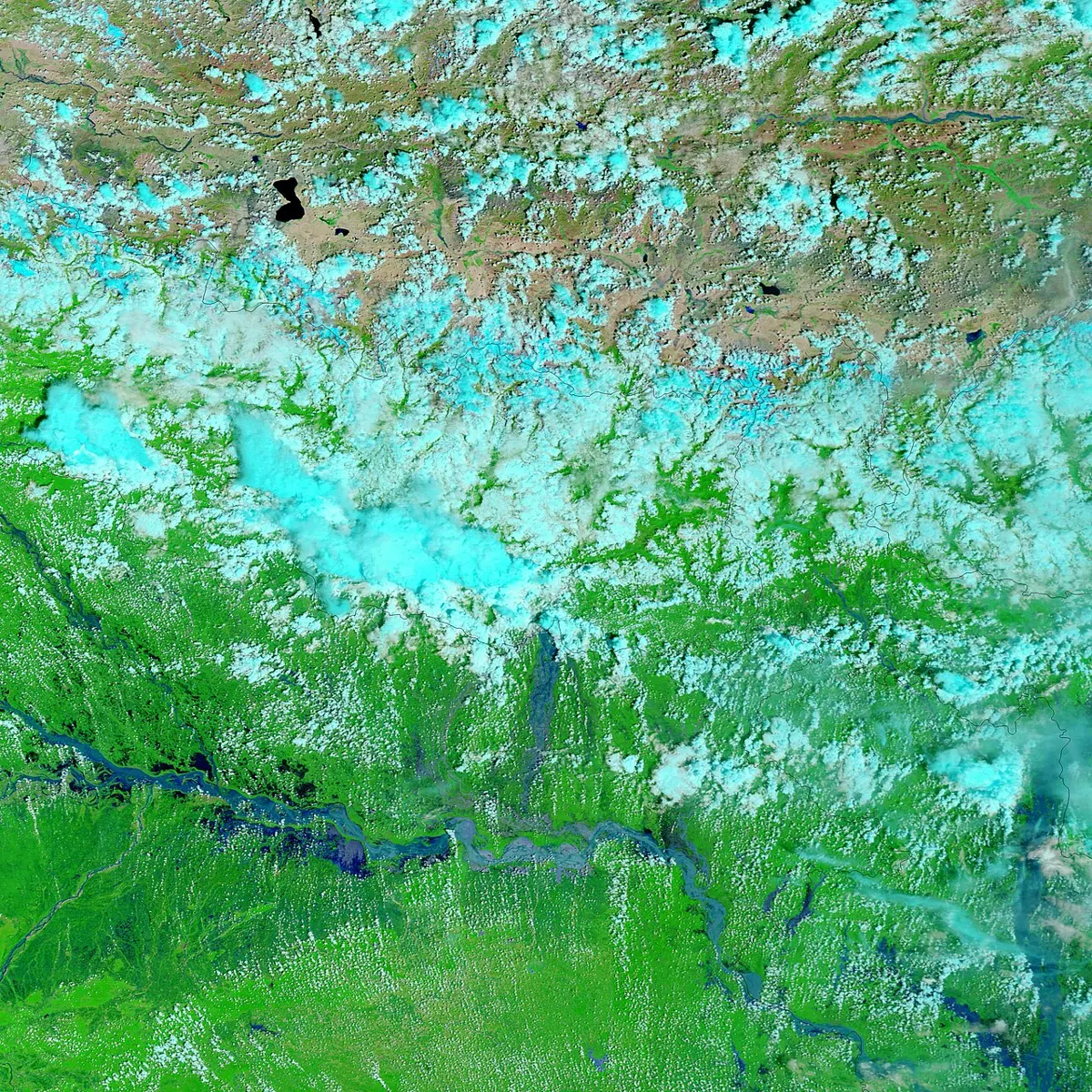
Strangest of all, the river was low. The breach came at less than a sixth of the flow the banks had been built to hold. The Koshi wasn’t pushed out by a great flood; in a sense, it had been waiting to leave. To see why a river would do such a thing, it helps to follow one from the beginning.
How a river works
A river starts as rain, or as snow and ice that melt. Some of the water soaks into the ground and some runs off over the surface, and the part that runs off always goes downhill. Trickles join into rills, rills into streams, streams into rivers. In Nepali the names climb with the size: खोल्सी, the small gully, then खोला, then नदी.
All along the way a river does three jobs. It wears the land away, it carries what it has worn off, and it drops it again somewhere else. Which job it does at a given place depends on two things: how much water it has and how steep its bed is. Lots of water on a steep slope moves fast and has great force; it can roll boulders and grind its bed lower. The same water on a gentle slope slows down, and as it slows it lets go of the heaviest things first.
The river can’t cut lower than the sea it flows into, and that bottom level sets the shape of the whole journey. Near the source a river has a long way to fall and little water to do it with, so it is steep and fast. Near the sea it has almost no height left to lose, so it is wide and slow.
What it carries changes too. Pick up stones from a mountain stream and they are big and sharp-edged. Farther down they are smaller and round, because each one has been rolled and knocked against the others until its corners broke off. Lower still there is gravel, then sand, then fine mud. The Koshi is one of the muddiest big rivers in the world. It carries about 43 million tonnes of rock waste a year, and for each square kilometer of land it drains, it carries about three times as much as the Amazon.
Textbooks draw a river’s fall as one smooth curve, steep at the top and flattening toward the mouth. A real river is rarely so tidy.
Heights traced from MERIT Hydro (Yamazaki and others, 2019, University of Tokyo), under the Open Database License (ODbL 1.0); our traced profile is under the same license.
Its biggest branch, the Arun, rises in Tibet at about 5,400 m and runs for some 300 km across the plateau, falling only about 2 m for every kilometer. Then it turns south and drops through the Himalaya, losing more than 3,500 m of height in under 200 km; how it came to cut through the range at all is a story told in Mountains, Plateaus and Plains. At Tribeni the Arun meets the Sun Koshi and the Tamor, and a little below, at Chatara, the river leaves the hills. From there to the Ganga is about 300 km, and in all that way the bed falls only about 80 m, roughly 27 cm for each kilometer. That change, from a river that falls meters in every kilometer to one that falls centimeters, where it leaves the hills, is the key to everything that happened at Kusaha.
The shapes a river makes
High up, where the river is cutting down, it makes valleys shaped like a V. The river saws a narrow slot, and the slopes on either side crumble and slide into it, so the valley is wide at the top and narrow at the bottom. Where the rock is hard enough to stand up in walls, the valley becomes a gorge. The most famous is the Grand Canyon in Arizona, where the Colorado River has been cutting for five or six million years. The river runs through it for about 447 km, it is on average about 1.6 km deep, and at the bottom the river has reached rocks 1.8 billion years old.
A river crossing hard rock and then soft rock makes a waterfall. The soft rock below wears away faster, so the hard layer on top is left sticking out as a lip, until it breaks off and the fall moves back upstream a step. Niagara Falls, on the border of Canada and the United States, has moved back about 11 km this way in some 12,000 years, leaving a gorge behind it. Below a fall, or anywhere fast water spins stones around, the stones drill round holes into the bed, called potholes. Pokhara has a famous fall, पाताले छाँगो, where the stream flowing out of Phewa Lake drops into a hole and vanishes under the ground.
On the plains the river no longer has the speed to cut much deeper, so it starts to swing from side to side. Once a river bends a little, the water on the outside of the bend runs faster and eats into the bank, while the water on the inside runs slower and drops sand there. The outside moves out and the inside builds up, so every bend grows. A river on flat land ends up as a ribbon of great loops, called meanders.
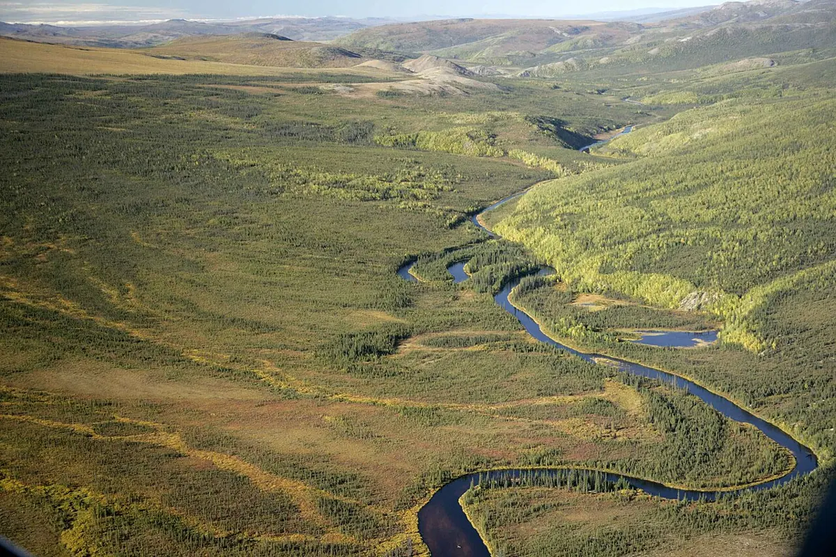
Sooner or later two loops grow so close that the river breaks through the neck between them, usually in a flood, and takes the short way. The abandoned loop is left as a curved lake, an oxbow lake, which Nepali calls गोरुजुरे ताल; the Terai’s rivers have them. Mark Twain, once a Mississippi steamboat pilot, wrote that more than once that river had shortened itself by 30 miles in a single jump, and that a man living in the state of Mississippi one day could find himself and his land the next day on the other side of the river, in Louisiana. Then he had some fun with the numbers. The lower Mississippi, he said, had shortened itself by 242 miles in 176 years, so anyone could work out that in 742 years it would be only a mile and three-quarters long, and the cities of Cairo and New Orleans would have joined their streets together. “There is something fascinating about science,” he wrote. “One gets such wholesale returns of conjecture out of such a trifling investment of fact.”
When a river on a plain floods, it spills over its banks onto the flat land around it, its floodplain. The water slows the moment it leaves the channel, so it drops its coarsest sand right beside the banks and carries only the fine mud farther out. Flood after flood, the banks build up into low ridges, natural levees, and the floodplain gets a fresh coat of fertile mud. When a river later cuts down into its own old floodplain, the old floor is left as a step above the new one, a terrace, and nearly every river coming out of the Himalaya has them. A river carrying more than it can manage may also split into many channels that braid in and out of each other around sand bars, as the Koshi does on its fan.
At last the river reaches the sea and stops. Everything it still carries settles out at its mouth and builds new land, a delta. The name comes from the Nile, whose mouth spreads out in the shape of the Greek letter Δ. Herodotus, the Greek historian, already called it the Delta about 2,400 years ago. He agreed with the Egyptian priests that the river had built it: Egypt, he wrote, was “a gift of the river”. The Ganga and the Brahmaputra together have built a much bigger one: most of Bangladesh stands on it.
Fans and wandering rivers
Most of the plains of the world are made this way, of the mountains carried down and laid flat. Nepal’s Terai is the Himalaya’s own waste, and the way it is laid down explains the Koshi.
At Chatara the river comes out of its gorge onto open land, and from there its slope dwindles to almost nothing. It has far more rock than it can carry, so it drops it, the boulders first, then gravel, then sand. The dropped load raises the river’s bed. Before long the river is running a little higher than the land beside it, and at the next big flood it spills over to the lower ground and takes a new course there. Then the new bed fills up in turn. Swinging back and forth like this from the point where it leaves the hills, a river spreads its waste out in the shape of an open fan, an alluvial fan. The Koshi’s covers more than 10,000 km².
People have tracked the Koshi’s wanderings on old maps going back to the 1700s. Many books and papers, Wells and Dorr’s of 1987 among them, have said that in two centuries the river crossed the fan from east to west, in jumps or more smoothly, by more than a hundred kilometers; published figures range from 113 to 150 km. In 2010 a team led by Tapan Chakraborty went back over 28 maps from 1760 to 1960 and doubted the westward march. On their reading the river had mostly stayed a little east of the fan’s middle, swinging back and forth at random, and a march that fast would need the fan’s top layers to have been laid down unusually fast. Others, Sinha among them, still describe a mainly westward shift. Nobody disputes that the river moves. How it moves is still argued.
In the mid-1950s people decided to stop it. After an agreement between Nepal and India in 1954, embankments were built along both sides of the river, and a barrage across it near the border. The banks held the river in a corridor, but it kept dropping its load, now inside the corridor, so its bed kept rising. After the breach, beside the western bank, the bed was found to be at least 4 to 5 m higher than the land outside. The river was running on a raised shelf with fields below it on either side. When the eastern bank, poorly kept for years and worn away at its foot, finally gave way, the water did what water does and went downhill, into one of the Koshi’s old courses. Sinha put the jump at about 120 km east; Chakraborty’s team, measuring across the middle of the fan, put it at about 60. The gap was closed and the river turned back into its corridor on 26 January 2009.
The geologist Rajiv Sinha, who studied it, called it one of the greatest jumps of a large river in recent years, and “partly a human disaster”: a river held in a bed that kept rising, and banks left unmended. The raised bed is still there, and he warned that another breach could not be ruled out.
A river’s whole country
Rain that runs off a slope ends up in some river, and all the land whose rain reaches the same river is that river’s basin. The line on the high ground between two basins is a divide. Stand on one side of a ridge and the rain runs one way; stand on the other side and it runs another, to a different river and sometimes a different sea.
Nepal’s rivers all end in the Ganga, whose basin covers a little over a million square kilometers. The largest basin in the world, the Amazon’s, is about seven times as big. To see any river on Earth with its basin, open Rivers of the World and tap it; its Nepal button shows every stream in the country, colored by the river it leaves Nepal in.
A basin’s edge is drawn by the land, and it pays no attention to the lines people draw. Of the land that drains into the Koshi above the point where it leaves Nepal, about 55,700 km², half is in Tibet. Rain and snowmelt in Tibet and mud off fields in Sankhuwasabha all end up on the plains of Bihar. The Karnali is the other way round, almost all of it inside Nepal, while two-thirds of the Mahakali’s basin lies in India. People upstream and downstream both depend on a shared river, and they don’t always see it the same way.
Take the Koshi agreement of 1954. Under it India built the barrage and the embankments on land in Nepal, at its own cost, for flood control, watering fields and power. The land taken became India’s property, though Nepal kept its rule over it. The agreement lists what Nepal was to get: its land on the river’s west bank protected from the river, the right to take water for its own fields, up to half the electricity made at the barrage, and royalties. Many people in Nepal have come to see it as one of the unequal treaties with India, and after the 2008 breach Nepal’s new prime minister called it a “historic mistake”, because, he said, India took the lion’s share of the benefit and left Nepal the harm. Over the breach itself, each side blamed the other. India’s embassy said the disaster could have been averted if security had been seen to and local people had cooperated, since its engineers had been kept from their repairs. Nepali officials said that under the agreement India was in charge of the banks and hadn’t mended them in time.
The same arguments run along rivers all over the world. India and Pakistan took nine years to agree, in 1960 and with the World Bank’s help, how to share the Indus and its tributaries: the three eastern rivers to India, the three western ones to Pakistan. It lasted through wars. In April 2025, after an attack on tourists in Kashmir, India said it would hold the treaty in abeyance until Pakistan “credibly and irrevocably abjures its support for cross-border terrorism”. Pakistan answered that the treaty allows neither side to suspend it, and that any attempt to stop or divert its water would be considered an act of war.
Water under the ground
The rivers are only the part of the water you can see. Of all the fresh water on Earth, more than two-thirds is frozen in ice, about 30 percent is under the ground, and only a little over 1 percent is in lakes, rivers, swamps and the like. Rivers hold under half a percent of that.
Underground, water mostly doesn’t sit in hidden lakes. It fills the tiny spaces between grains of sand and gravel and the cracks in rock, the way water fills a sponge. Below a certain depth every space is full; the top of that soaked layer is the water table. A well works by reaching below it. Where the water table meets the surface on a hillside, the water comes out as a spring. And between rains the ground keeps leaking water into the rivers, which is why a stream can keep flowing for weeks after the last shower: in a dry spell, much of what you see in a river came out of the ground.
Ground water can be used up. Pumping faster than rain can refill the ground makes the water table drop, and wells go dry. The High Plains aquifer, under the American Great Plains, waters fields in parts of eight states, and in places its level has fallen more than 30 m.
Where the rock is limestone, which the faintly acid water slowly dissolves, ground water makes a hidden landscape of its own. Over thousands of years cracks widen into passages and passages into caves. Near Pokhara, Mahendra Cave was hollowed out this way, and at Armala the ground is pitted with sinkholes, bowls where the limestone underneath has been dissolved away; in Khotang, Halesi’s caves are another. In country like this a river can sink underground for a while, carving in the dark what rivers everywhere carve in the open.
Somewhere on the Terai this minute, the Koshi is laying down the next layer of the plain, and high above, where its water begins, ice is doing the same job in its own slow way.
Found a mistake? Please tell us.