
In the winter of 1736, in the far north of what was then Sweden, a party of French scientists went out onto the frozen Torne River with six wooden poles, each cut from a spruce log to exactly 30 feet. With them they measured a line along the ice more than 13 km long. One of them, a priest called Réginald Outhier, explained in his journal why they had waited for the cold: the line “could not be measured at any other time than in winter over the ice.” All summer they had been climbing the hills along the valley, building pyramids of stripped tree trunks on the tops so that each could be sighted from the next. Now, on the ice, they were measuring the one straight line that all their angles would hang from.
They weren’t making a map of Lapland. They were trying to find out the shape of the whole world. In Paris that question had become a quarrel, and France had sent two teams to settle it: this one to the Arctic Circle, and another to the equator, in South America. The answer they brought back is the one in every atlas today. Here it is first, and then how anyone found it out.
A ball, very slightly squashed
The Earth is a ball about 12,700 km across. Go once around it at the equator and you have traveled about 40,075 km. Its surface is about 510 million square kilometers, and a little over 70% of that is sea.
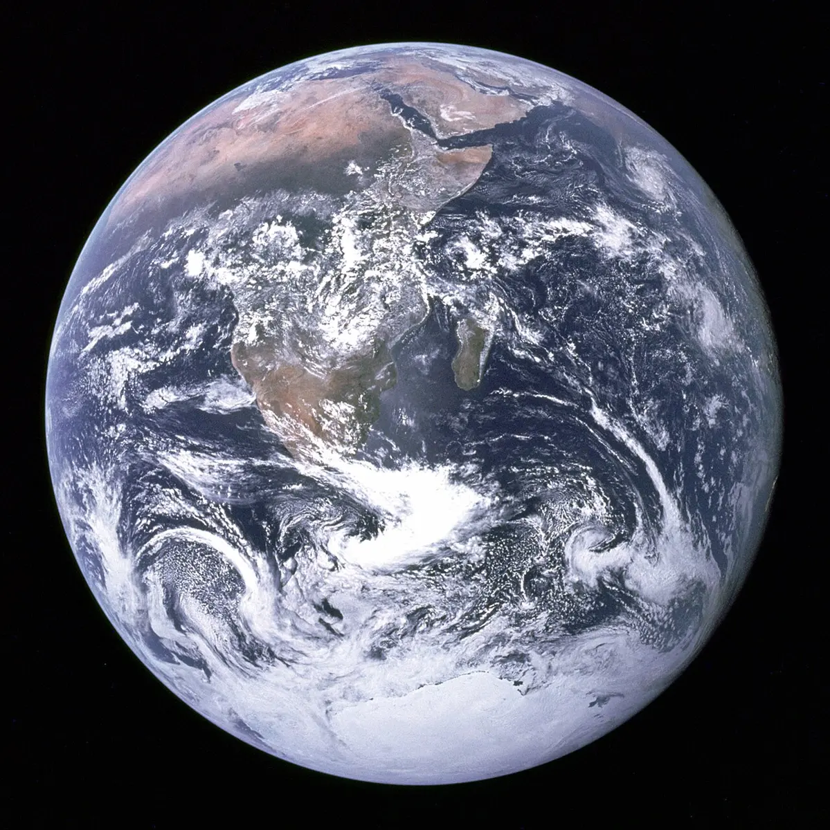
It isn’t quite a perfect ball, though. It bulges a little around the middle and is a little flat at the poles. From the center to the equator is about 6,378 km. From the center to either pole is about 6,357 km. The difference, 21 km, is about a third of one percent. If you drew the Earth to scale as a ball 20 cm across, its height from pole to pole would be less than a millimeter short of its width, thinner than the pencil line. That’s why it looks perfectly round from space, and why “a ball slightly squashed”, or the old comparison with an orange, is the honest description.
The squash comes from the spin. The Earth turns once a day, so a place on the equator is carried around 40,075 km every 24 hours, nearly 1,700 km an hour. Kathmandu, nearer the axis, goes around a smaller circle at nearly 1,500 km an hour. Anything turning in a circle tends to fling outward, and the faster it turns, the stronger the fling. Gravity pulls the Earth into a ball; the spin pushes its middle outward. The shape that balances the two is a ball with a bulge where the spin is fastest, at the equator, and flattened where it is slowest, at the poles.
That’s the whole answer. Working it out took about two thousand years.
How people knew it was round
In the fourth century BC, when some Greeks still pictured the Earth as a flat drum, Aristotle argued that it was a ball, and wrote down why. Watch an eclipse of the Moon, he said. The Earth’s shadow creeps across the Moon, and its edge is always curved. The Moon shows plenty of other shapes in a month, half-moons with straight edges among them, but the shadow in an eclipse is always part of a circle, and only a ball casts a round shadow from every side.
His second reason was the stars. Walk or sail a little way north or south and the sky changes. “There are some stars seen in Egypt and in the neighbourhood of Cyprus which are not seen in the northerly regions,” he wrote, and stars that never set in the north rise and set farther south. On a flat Earth everyone would see the same sky. On a ball, each step south tips you a little, and new stars come up over the southern edge. Since a short journey changed the sky so much, he added, the ball can’t be very big. So he wouldn’t rule out a guess that was bolder than it sounds: that the far west of the known world and India might not be so far apart, with one ocean between them. Those who thought so pointed to the elephants found at both ends.
About two thousand years ago the geographer Strabo added what sailors saw. A light on a distant shore is hidden by the curve of the sea from a man on deck, but appears if he climbs higher. And as a ship comes toward land, the shore seems to rise out of the water, its high parts first and the low-lying land last.
Knowing it was a ball, someone was bound to try to measure it. The famous attempt is by Eratosthenes, the librarian at Alexandria, around 240 BC. At noon on midsummer’s day the sun shone straight down a well at Syene, today’s Aswan, far up the Nile. At the same moment in Alexandria, to the north, a stick cast a short shadow, showing the sun a fiftieth of a circle away from overhead. So the distance between the two cities must be a fiftieth of the way around the Earth. He took it as 5,000 stadia, which made the Earth 250,000 stadia around. How close that is, nobody knows, because nobody knows exactly how long his stadion was. But the method is sound, and you can try it yourself with a stick and a friend in another town: How Did Eratosthenes Measure the Earth? works it through step by step.
Lemon or orange
For the next two thousand years the size was measured better and better, and people took the shape to be a perfect ball. Then, in the 1670s, a French astronomer named Jean Richer took a pendulum clock to Cayenne, in South America, close to the equator. He found that a pendulum swinging once a second there had to be nearly 3 mm shorter than in Paris. Something was making things fall slightly more weakly near the equator.
Isaac Newton had an explanation. If the spinning Earth bulges at the equator, a place there is farther from the center, where gravity pulls a little less, and the spin itself flings it outward a little more. In his Principia of 1687 Newton worked out how much bulge his laws predicted: the Earth’s width at the equator should be to its height from pole to pole “as 230 to 229”. An orange, slightly flattened.
The astronomers of Paris disagreed. The Cassinis, father and son, had measured the length of France from north to south, and their numbers said the Earth was stretched at the poles, not flattened: a lemon, not an orange. It mattered more than it sounds, for this was a test of whether Newton’s physics was right.
There was a way to settle it. Walk north until the stars have shifted by one degree, and measure how far you walked. On a perfect ball every degree is the same length. But where a surface is flatter, its curve bends more gently, and you have to walk farther before the stars move by the same amount. So if Newton was right, a degree should be longest near the flattened poles and shortest near the bulging equator. If the Cassinis were right, the other way round. Measure a degree in the far north and one at the equator, and compare.
That’s why the French Academy of Sciences sent two expeditions. The one to the equator left France in May 1735: Charles Marie de La Condamine, Pierre Bouguer and Louis Godin, with two young Spanish officers, Jorge Juan and Antonio de Ulloa. They measured a chain of triangles about three degrees long along a high valley of the Andes, from near Quito down to Cuenca, in what is now Ecuador. The other, led by Pierre Louis Maupertuis, with the Swedish astronomer Anders Celsius, the man the temperature scale is named after, reached the town of Tornio on 19 June 1736. That was the team on the ice.
The northern team was quick. Its chain of triangles ran about 110 km up the valley, from the church tower at Tornio to a hill called Kittisvaara, and at each end they measured how far a star, δ Draconis, passed from the point straight overhead. By June 1737 they were finished. On the way home their ship was wrecked in the Baltic, though no one was lost, and neither were the instruments or the notebooks. Their degree came out at about 57,400 toises, the French measure of the time, longer than the degree measured in France. Maupertuis wrote to the English astronomer James Bradley: “Thus, Sir, You See the Earth is Oblate, according to the Actual Measurements, … and this flatness appears even more considerable than Sir Isaac Newton thought it.”
It did appear more considerable than it is. Later surveyors went back to the Torne valley in 1801 and again in 1928 and found Maupertuis’s degree too long; set beside the Earth’s shape as it is known today, it is about 400 m too long. The answer was right, but the size of the squash was exaggerated.
The southern team took far longer. Their survey was done by 1739, but checking the stars against it kept them in the Andes for years more. The scientists quarreled too: Godin wouldn’t share his results, and in December 1741, when Bouguer found a mistake in one of La Condamine’s calculations, the two stopped speaking to each other, and finished their work separately in May 1743. With no money to sail straight home, La Condamine went home the long way, down the Amazon. He reached the Atlantic in September 1743, waited five months in French Guiana for a ship he could safely take while France was at war, and reached Paris in February 1745, nearly ten years after he left. Their degree at the equator was the shortest of all, about 56,750 toises. Lapland’s was longer than France’s, and France’s longer than Peru’s. The Earth was an orange.
One more thing came out of these journeys, and it is probably in your school bag. In the 1790s France wanted a measure of length that belonged to nobody, and chose the Earth itself: a meter was to be one ten-millionth of the distance from the North Pole to the equator, measured through Paris, with the squash allowed for from the measurements made in France and in Peru. That is why the distance around the Earth through the poles comes out at almost exactly 40,000 km: it is 40,008 km, because the first meter bar was made about 0.2 mm too short.
Measured from space
Nobody needs to measure angles on the ice anymore. Since the first satellites of the late 1950s, the Earth’s shape has been read from the paths of satellites, which the bulge tugs slightly as they pass over it. Today the shape your phone’s GPS uses is a squashed ball called WGS 84, whose flattening is set at about 1 part in 298. Newton’s 1 in 230 was too much, and Lapland’s more still, but the shape was right.
The top of Everest, at 8,849 m, is the highest point above sea level. But the point on the Earth’s surface farthest from its center is the top of Chimborazo, a 6,263 m volcano in Ecuador, the same country where the Peru expedition measured. Chimborazo is only about one and a half degrees south of the equator, on top of the bulge, so its summit is about 6,384 km from the Earth’s center, roughly 2 km farther out than Everest’s. Earth’s Extremes has both, with the deepest, hottest and coldest places beside them.
Satellites also showed that even the sea isn’t a smooth squashed ball. The rock deep inside the Earth isn’t equally heavy everywhere, so gravity isn’t quite the same everywhere, and the sea’s surface follows gravity. If the ocean were completely still, its surface would bulge about 85 m above the smooth shape near Iceland and dip about 106 m below it in the Indian Ocean, south of India, the deepest dip of all. This lumpy surface is called the geoid, and heights above sea level, Everest’s included, are measured from it.
Land and water
Turn the globe and you see at once that the Earth’s land and sea aren’t mixed evenly. Most of the land is crowded into one half of the planet. About two-thirds of it lies north of the equator, and if you choose the half of the Earth with the most land in it, centered near Nantes, in western France, it holds about four-fifths of all the land there is. Even that half is a little more sea than land. The opposite half, centered on the Pacific near New Zealand, is nine-tenths water.
People divide the land into continents, and in Nepal, as in most of the English-speaking world, India, China and many other countries, there are seven. By size they are Asia, Africa, North America, South America, Antarctica, Europe and Australia. Asia alone is about 30% of all the land, and Nepal is in it, on its southern side, where the high middle of the continent comes down to the plains of India. Africa comes next, with the equator running almost through its middle, so that its north and south have their seasons at opposite times of year. North America takes in Greenland, the largest island on Earth. South America runs from the hot north, across the equator and down almost to Antarctica. Antarctica is a continent almost entirely under ice, with no country of its own. Europe isn’t separated from Asia by any sea at all: the line between them is drawn by agreement, mostly along the Ural Mountains in Russia. Australia is the smallest continent, so small that Greenland’s area would fit into it more than three times over.
The number seven isn’t a law of nature. A continent is meant to be a large mass of land with sea around it, but only Australia and Antarctica are cut off all around. Africa is joined to Asia at Suez, and the two Americas meet at Panama. In much of Latin America the Americas count as one continent, which gives six. The five rings of the Olympic flag stand for the five continents where people live, with the Americas as one and Antarctica left out. In Russia, Europe and Asia are often counted as one, Eurasia. And in 2017 a group of geologists, who count by the rock rather than the coastline, argued for one more, almost all underwater: Zealandia, around New Zealand.
Seven is an old number in South Asia too. The विष्णु पुराण (Vishnu Purana) describes the world as seven great island-continents in rings, with the golden Mount Meru in the middle of the innermost, जम्बूद्वीप (Jambudvīpa), and each ring separated from the next by a sea: of salt water, of sugarcane juice, of wine, of ghee, of curd, of milk, and of fresh water. The two sevens have nothing to do with each other.
The water, unlike the land, is really all one. Every ocean runs into every other, so there is only one world ocean, and its parts are named by custom. The Pacific is by far the largest, about 155 million square kilometers by itself, more than all the land on Earth put together. Ferdinand Magellan named it in November 1520, when his ships came out into it from the dangerous straits near the tip of South America and found the water calm, pacific, peaceful. It is also the deepest: at the Challenger Deep, in the western Pacific, the sea floor is about 10,935 m down. Drop Everest in there and its summit would still be about 2 km under water. Then come the Atlantic, between the Americas and Europe and Africa, and the Indian Ocean, the one nearest Nepal, whose northern arm is the Bay of Bengal. The Southern Ocean, the cold water that runs all the way around Antarctica, was long treated as just the southern ends of the other three. Its boundaries were proposed in 2000, most countries now count it as a fifth ocean, and National Geographic’s maps added it in 2021, though the world’s map-makers still haven’t formally agreed where it ends. The smallest is the Arctic, around the North Pole, partly frozen over.
That is the first tour. On the site’s World Map you can spin the globe yourself and open any country, with its size set beside Nepal’s and its distance from Kathmandu. Draw the Continents gives you each continent on a sheet to trace, and Journey is a game of getting from one country to another across the map. The continents one by one, in Nepali, are in Grade 6’s सामाजिक book, and the oceans and seas in Grade 7’s.
Found a mistake? Please tell us.