
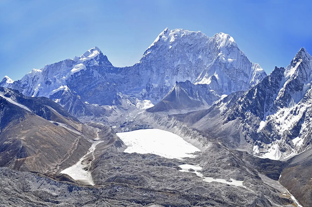
On 4 August 1985, a slab of ice broke off the Langmoche Glacier, high in the Khumbu, and fell into the lake below it. The lake was called Dig Tsho. The ice that went in was, by one estimate, about 150,000 cubic meters, enough to fill sixty Olympic swimming pools, and it pushed up a wave that ran across the lake and over the bank at the far end.
That bank was not rock. It was a heap of loose stones and sand that the glacier had pushed there long before, and once water was pouring over it, the water began to cut it away. The lake emptied itself down the valley of the Bhote Kosi and on into the Dudh Kosi: millions of cubic meters of water, five to ten million by different estimates, carrying boulders and mud. It destroyed the nearly finished Namche hydropower plant, 14 bridges, about 30 houses and many hectares of farmland. A few people died; one count says five.
Everything in that story was made by ice. The ice carved the hollow, the ice built the dam, the ice melted to fill the lake, and the ice fell in and broke it. This chapter is about the two forces that shape the land where water is scarce or frozen: ice in the cold, and wind in the dry. Both work far more slowly than a river most of the time. Now and then, as at Dig Tsho, they don’t.
How a glacier works
Nepali calls a glacier हिमनदी (himnadī), a river of snow, and that is very nearly right. It is a river of ice.
It starts with snow that doesn’t melt. High on a mountain, more snow falls in a year than the summer can get rid of, so each winter’s snow is buried under the next. The weight of the snow above squeezes the snow below, pressing out the air, until over the years it turns into solid ice. When the ice is thick enough, a few tens of meters, it can no longer hold its shape. It starts to flow downhill under its own weight, slowly, the way very thick honey does, and it slides on a film of meltwater underneath.
So a glacier has two ends doing opposite things. Up high, where it gains more snow than it loses, it grows. Lower down, where the air is warmer, it melts faster than snow can fall. The ice in between is always on the move, carried from where it is made to where it melts, and the snout, the glacier’s lower end, sits where the two balance. If summers warm, the snout moves back uphill. The ice itself still flows down; it just melts away sooner.
That flow can be measured with a few sticks. In 1872 the naturalist John Muir drove stakes into the Maclure Glacier in California, in what is now Yosemite National Park, and watched them move: about 2.5 cm a day. In 2012 scientists repeated his experiment and got almost exactly the same speed, though the glacier was by then less than half its old size. Its neighbor, the Lyell Glacier, had stopped moving altogether, and since a glacier by definition moves, the scientists noted that the word may no longer fit it. It is just a patch of ice now.
Glaciers cover about a tenth of the world’s land today, and almost all of that is the two great ice sheets of Antarctica and Greenland. In the last ice age, about 21,000 years ago, ice covered about a quarter of the land, including nearly all of Canada and much of northern Europe.
Nepal has a great many small ones. The Randolph Glacier Inventory, which outlines every glacier on Earth from satellite pictures, counts about 4,500 in Nepal, together covering about 4,200 square kilometers around the year 2000. The longest are in the east: a glacier on Kangchenjunga’s north side, unnamed in the inventory, at about 24 km; the Yalung, on its south side, at about 23; the Ngozumpa at about 22; the Langtang glacier at about 20; the Khumbu, which climbers cross on the way up Everest from Nepal, at about 18.5. Yet for all that number, the ice keeps to the very top of the country.
On the Koshi line, ice lies beside only about 16 of the 173 km of Nepal, all of it on the last climb to Makalu and the border. The other lines are much the same. In a country famous for its snow peaks, the ice is a thin white cap on a land that is mostly hills.
What ice carves
A glacier is not just ice. As it moves, water seeps into cracks in the rock beneath it and freezes, and the moving ice tears loose blocks of rock and carries them off. The stones frozen into its underside then grind over the bedrock like the grit on sandpaper, scratching long, straight lines in it that show, thousands of years later, which way the ice went.
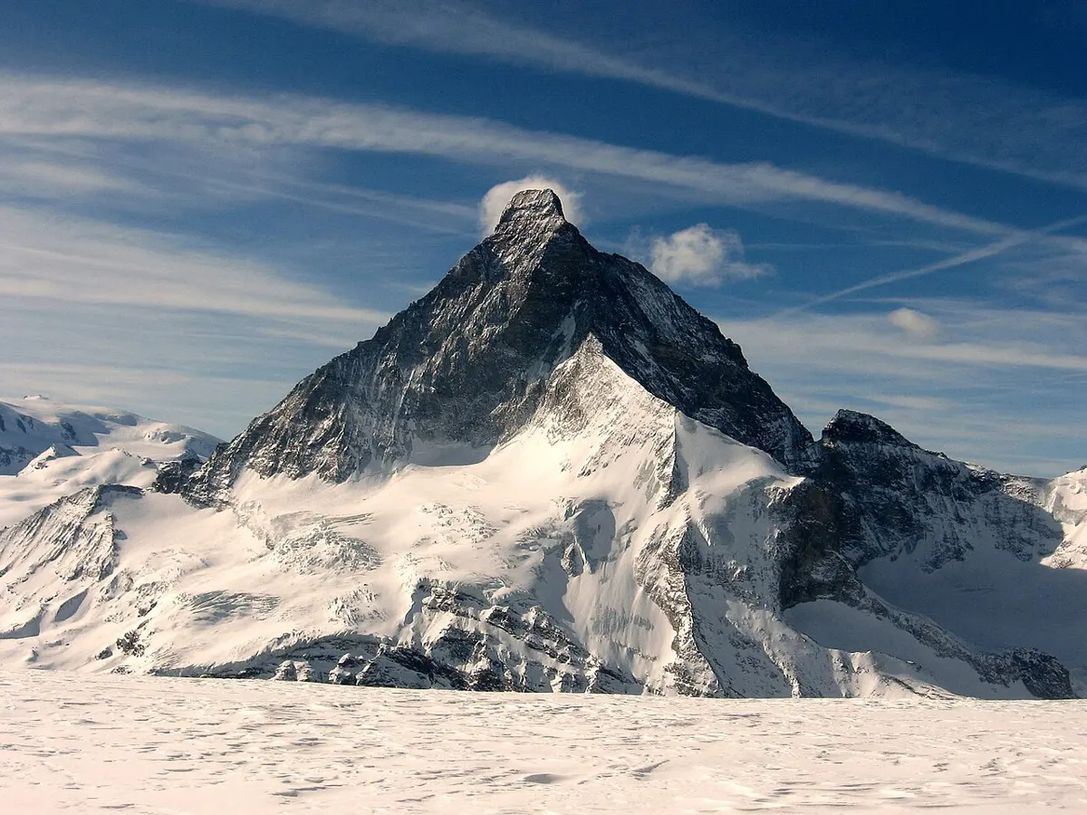
Where a glacier begins, high on a mountainside, it hollows out a bowl with steep walls on three sides, like an armchair. The bowl is a cirque, and when the ice has gone it often holds a small lake. When cirques eat into a mountain from two sides, the rock left between them is a knife-edged ridge, an arête. When three or four eat into one peak from all sides, what is left is a sharp pyramid called a horn. The Matterhorn, on the border of Switzerland and Italy, is the famous example.
Lower down, a glacier reshapes a valley. A river cuts down along a narrow line, so a river valley in the mountains is shaped like a V. A glacier fills its valley from wall to wall and grinds the sides as well as the floor, so it leaves a valley shaped like a U, with a flat floor and steep walls. Small side glaciers don’t cut as deep as the big one they join, so when the ice melts their valleys are left hanging high on the walls of the main one, and their streams fall off the edge. In Yosemite, Yosemite Falls drops 739 m in all from a valley like that. Where a U-shaped valley reaches the sea and the sea floods in, it becomes a fjord. Norway’s Sognefjord goes down 1,300 m below sea level, far deeper than the open sea beside it, because the ice cut that deep before it melted.
All the rock a glacier tears off has to go somewhere. It rides along on and in the ice and is dropped where the ice melts, in an untidy mix of boulders, gravel and fine mud called till. Heaped up, it makes moraines. A terminal moraine is the ridge of rubble pushed up at the snout, marking how far the ice reached. Lateral moraines run along the sides of the valley, where rock fell onto the edges of the ice. Two glaciers that join carry their edges’ rubble down the middle as a medial moraine. Meltwater pouring out of the snout spreads the finer stuff in a flat outwash plain; streams running in tunnels under the ice leave long winding ridges of gravel called eskers; and where ice sheets moved over soft ground, they shaped it into long smooth hills, steep at the end the ice came from, called drumlins, whole fields of them, about 10,000 in one field near Rochester in New York.
The boulders are the strangest leftovers. Here and there a glacier set down a rock quite unlike the rock around it, often hundreds of kilometers from where it came from. Big Rock, near Okotoks in Alberta, Canada, weighs about 16,500 tonnes. These wanderers are called erratics, from the Latin for wandering, and they are how people first worked out that the ice had once been far bigger. Naturalists studying the Alps, among them Jean de Charpentier and Karl Schimper, decided that the boulders of Alpine rock scattered over the Jura mountains had been carried there by glaciers. In 1837 the Swiss naturalist Louis Agassiz, who had been expected to talk about fossil fish, stood up at a scientific meeting in Neuchâtel and went much further: Europe, he said, had once been buried under ice. His book of 1840 described the scratches, the moraines and the rounded rocks, and the idea of the ice ages took hold.
Yosemite Valley shows nearly all of it in one place: a U-shaped valley, hanging valleys with their waterfalls, and a flat floor. The floor is flat because a terminal moraine near the foot of El Capitan held back a lake, and the lake filled up with mud.
Lakes behind the ice
Which brings the story back to Dig Tsho. A lake behind a moraine is the natural end of a glacier that is shrinking. The snout melts back, leaving its old terminal moraine standing across the valley like a dam, and meltwater fills the hollow between the two.
In the Himalaya many such lakes begin on top of the glacier itself. Small ponds of meltwater appear on the ice, grow, and run together, and in time the lake sits behind the moraine. Imja Tsho, in the Khumbu, was a handful of ponds on its glacier in a satellite picture of 1962. The ponds merged into one lake in the 1970s, and by 2000 it covered about 0.8 square kilometers. Tsho Rolpa in Rolwaling grew the same way.
What makes such a lake dangerous is its dam. A moraine is loose rubble, sometimes with old ice buried inside it, never built to hold water back. Most often it fails the way Dig Tsho’s did. Something falls into the lake: ice breaking off a glacier above, a rock avalanche, a landslide. It raises a wave, the wave pours over the dam, and the running water digs a channel that grows deeper by the minute, until the lake drains through it in a few hours. Glaciologists call the result a glacial lake outburst flood.
The most famous happened in Peru. On 13 December 1941 ice fell into Lake Palcacocha, high in the Cordillera Blanca, and its moraine gave way. The flood picked up mud and boulders as it went and poured into the town of Huaraz below. The best estimates say it killed about 1,800 people; some put the toll far higher.
Nepal counts its lakes carefully. Mapping from satellite pictures of 2015 found 2,070 glacial lakes in Nepal, and across the Koshi, Gandaki and Karnali basins, in Nepal, Tibet and India together, 47 that could be dangerous. Forty-two of them are in the Koshi’s basin. Only 21 are in Nepal; one is in India, and 25 lie in Tibet, upstream of Nepal, because rivers, and floods, cross borders.
There is a way to make a lake safer, and it is simple to say: let some water out. A lower lake needs a bigger wave to spill over its dam, and holds less water if the dam does go. At Tsho Rolpa the water was lowered by more than 3 m in 2000. At Imja, in 2016, the Nepal Army dug a channel through the moraine that lowered the lake by 3.4 m. Both lakes are still on the list, and both are still growing as their glaciers melt back. Palcacocha has been drained down too, and it has kept growing as well. How fast the Himalaya’s ice is shrinking, and what that means for its lakes and rivers, is a story for the chapter on the changing climate.
Where the wind takes over
Ice needs cold. Wind needs dryness. In a wet place the wind blows just as hard, but plants and damp soil hold the ground down. Where there is little rain, there are few plants, and loose grains lie bare for the wind to pick up.
A desert is a place defined by that dryness, not by heat or sand. The usual line, drawn by the geographer Peveril Meigs in 1953, is 250 mm of rain a year: below it the land is arid, a desert; between 250 and 500 mm it is semi-arid, grassland or steppe. By that measure about a third of the Earth’s land is desert. Some deserts are hot, like the Sahara; some are cold, like the polar deserts, where the Dry Valleys of Antarctica have been free of ice for thousands of years. And most aren’t sandy. Sand covers only about a fifth of the world’s deserts. Nearly half are flat plains of pebbles, and the rest is bare rock, gravel and dry lake beds.
The wind works in three ways. First, it sweeps. It lifts the fine dust and sand and carries it off, leaving behind the stones too heavy to move, until the ground is paved with them. That is where the stony plains come from: the wind has taken everything small.
Second, it blasts. Sand doesn’t rise very high: it travels in low hops, each grain knocked up by the one landing behind it, so most of it moves close to the ground. Blown against a rock, it wears away the bottom faster than the top, and a lone rock can end up balanced on a narrow stalk, a mushroom rock. On a bigger scale, wind carves rock into long streamlined ridges called yardangs. In the Lut desert of Iran they stand almost 100 m high.
Third, it builds. Where the wind slows, it drops what it carried. Sand piles into dunes, which move: sand blows up the gentle side facing the wind and tumbles down the steep side beyond it, so the whole dune creeps downwind. A dune fed by wind from one direction becomes a crescent with its horns pointing downwind, a barchan; crescent dunes are the commonest on Earth and on Mars. Winds from two directions often make long straight ridges, some more than 160 km long. Winds from every side make star dunes, which grow upward; in the Badain Jaran desert of China some stand about 500 m tall. The finest dust goes much farther, and settles as a soft soil called loess. China’s Loess Plateau, southeast of the Gobi, is made of it, in places 335 m thick, and over a hundred million people live on it.
Much of what is known about blowing sand comes from one man. Ralph Bagnold was a British army officer who spent his leave in the 1920s and 30s driving Ford cars deep into the Libyan desert. Out of those journeys came his book of 1941, The Physics of Blown Sand and Desert Dunes, which started the study of wind-blown sand as a science of its own. NASA has used his work to study the dunes of Mars, and a field of dunes there is named after him.
Still, the wind is not the strongest force even in a desert. Water is. Rain is rare, but when it comes it comes hard, onto bare ground with nothing to soak it up, and dry channels fill in minutes. More people drown in deserts than die of thirst.
Nepal’s own desert
Behind the Annapurna and Dhaulagiri ranges lies Mustang, high, brown and bare. It is the rain shadow from the monsoon chapter: the wet wind drops its rain on the south side of the range, and the far side gets little. Jomsom gets about 290 mm in a normal year, against more than 5,000 mm at Lumle on the other side.
So is Mustang a desert? By Meigs’s strict line, Jomsom just misses: 290 mm makes it semi-arid. Either way, it is Nepal’s nearest thing to one: a cold, high, dry land like the Tibetan Plateau it borders, with the Kali Gandaki running down the middle.
And Mustang has its wind. Nearly every day a strong wind blows up the Kali Gandaki from the south; scientists who tracked balloons along the valley in 1998 found it strongest between Marpha and Chuksang, typically 15 to 20 meters a second, 55 to 70 km an hour. Why a valley should blow so hard, so regularly, belongs to the chapter on air and wind.
What that wind does to the land is less clear. Mustang’s cliffs are honeycombed with some 10,000 caves, dug by people long ago, and its valleys are full of strange shapes, but we found no study that measures how much of them the wind has made. In most deserts it is water that does the heavier work, and Mustang is probably no different.
Ice and wind, then, are the sculptors of the cold and the dry, and they work at different speeds. Ice is slow: a few centimeters a day, carving a valley into a U over tens of thousands of years. Wind is slow too, a grain at a time. But both leave things lying about, a moraine across a valley, a dune on the move, that can change in an afternoon, as Dig Tsho did on 4 August 1985.
Found a mistake? Please tell us.