
On 23 June 1802 Alexander von Humboldt set out to climb Chimborazo, the great snow-capped volcano of Ecuador. With him went the French botanist Aimé Bonpland, a young man from Quito, Carlos Montúfar, and a man from a nearby village whose name Humboldt didn’t write down. They never reached the top. A gap in the ridge, about 15 m across and far deeper, stopped them, and the thin air made them sick and dizzy, with blood oozing from their lips and gums. Humboldt worked out that they had climbed to 5,878 m. Nobody knows how high they really got. Edward Whymper, who made the first climb to the top in 1880, studied the mountain and thought Humboldt could hardly have got beyond about 5,600 m.
What he carried down mattered more than the height. For months he and Bonpland had been collecting plants in the Andes and writing down where each one grew, and how high. In 1807 Humboldt published the result as one large picture: Chimborazo half cut away like a cake, with the names of plants written on it at the heights where they lived, and columns of measurements down both sides.
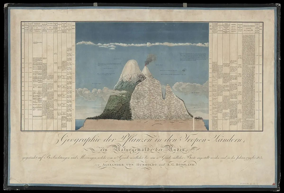
The picture shows something every mountain walker notices without trying. Plants don’t grow just anywhere. They live in bands, and the bands stack up a mountain in the same order as they lie across the Earth, from the hot middle toward the poles.
Nearly fifty years later an English botanist, Joseph Hooker, had to choose where to go. “My choice lay between India and the Andes,” he wrote, and he chose India, with Humboldt himself taking an interest in the plan. Late in 1848 he walked into eastern Nepal, up to the trading village he called Wallanchoon, Olangchung Gola in Taplejung today, and on into Sikkim. In January 1849, from a ridge facing Kanchenjunga, he looked south over the deep valleys toward the plains and counted “five belts: 1, palm and plantain; 2, oak and laurel; 3, pine; 4, rhododendron and grass; and 5, rock and snow.” From the palms in the bed of the river, he worked out, it was only seven miles in a straight line to the permanent ice.
Warmth, water and soil
Here is the idea underneath both pictures. A plant needs two things from the place it grows: warmth enough to grow, and water. Where both last all year, plants grow big and close together. Where one runs short for part of the year, they have to pause, and only some kinds manage that. Where either is missing almost all the time, very little grows at all. So the climate decides which plants can live in a place, the plants decide which animals can live there, and over thousands of years all of them together make the soil. A great stretch of the world with the same mix of climate, plants, animals and soil is called a living zone, or a biome. There are only a handful of big ones, and they follow the climates, which is why the map of them looks so like the map of climates.
Start at the equator, where it is hot and wet in every month. That is rainforest, the tallest and most crowded forest on Earth. Its trees reach 75 m, with two more layers of growth below them, and between 2,000 and 10,000 mm of rain falls on it in a year. It looks like the richest land there is. Yet in much of the rainforest, above all on the old, deeply weathered ground of the central and eastern Amazon, the soil underneath is poor. Months of heavy rain on warm ground have washed most of what plants need out of it, and fallen leaves rot so fast in the warm wet that their goodness is taken straight back up by the roots before it can build up in the ground. In forests like these, much of the wealth is in the living trees, not in the earth they stand on. Clear the trees and burn them, and the ash feeds a crop for two or three years. After that there is little left.
Move away from the equator and the rain comes in one season, as the rain belt passes over, and the rest of the year is dry. That is savanna: grass, with trees scattered across it but never closing over. Rain alone doesn’t decide where forest ends and savanna begins. Where 1,000 to 2,500 mm of rain falls in a year and the dry season is fairly short, a forest and a savanna can both last, and what tips a place one way or the other is fire. Fire runs through dry grass and kills young trees, which keeps the land open, and once a place is open the grass keeps the fires coming. A forest that escapes the fires long enough stays a forest.
Farther out lie the deserts, under the dry, sinking air where rain hardly ever falls.
Then come the mild lands, with a warm season and a cool one and rain enough in both. Where there is plenty of rain the natural cover is forest, and in the cooler parts it is broadleaf trees that drop their leaves each autumn, adding a fresh layer of food to the soil every year, so the soils under them are fertile. Where there is less rain, trees give way to grass: the steppe of Ukraine and Kazakhstan, the prairie of North America, the pampas of Argentina, with the black earth called chernozem under much of them, deep with the remains of grass roots.
Farther north still, where summers are short and winters long and hard, comes the taiga, the dark conifer forest that covers much of Canada and Russia. It is the largest living zone on land, about 11.5% of it. Its fallen needles turn the water that soaks through them acid, and the soil beneath is a pale, bleached podzol, poor for crops. Beyond the last trees lies tundra: low shrubs, grasses, mosses and lichens on ground that thaws for a few weeks a year. Below that thin top layer, it stays frozen year after year. Ground that stays frozen like that, permafrost, lies under about 15% of the land in the northern half of the world. Past the tundra is ice.
So the zones aren’t just climates with trees drawn on. The soil is part of each one, and the two work on each other. In the rainforest the wealth is above the ground; on the steppe it is in it. That difference shapes what people can do with each.
Up the mountain
Climb a mountain and the air gets colder, about 5 °C for every 1,000 m on Nepal’s slopes, so a few kilometers of climbing cools the air as much as thousands of kilometers of travel toward a pole. The living zones get squeezed into bands, and on a mountain as steep as the Himalaya the bands are narrow. That is what Hooker saw from his ridge, and what makes a walk in Nepal so odd: a day can take you through what would be weeks of travel on flat land.
The most obvious line on any mountain is where the trees stop. In Rolwaling, on slopes that face north and have been little touched, the forest of fir and भोजपत्र, the Himalayan birch whose papery bark was once used to write manuscripts on, gives way at about 4,000 m to a thick tangle of rhododendron bushes. Above that there are no trees at all.
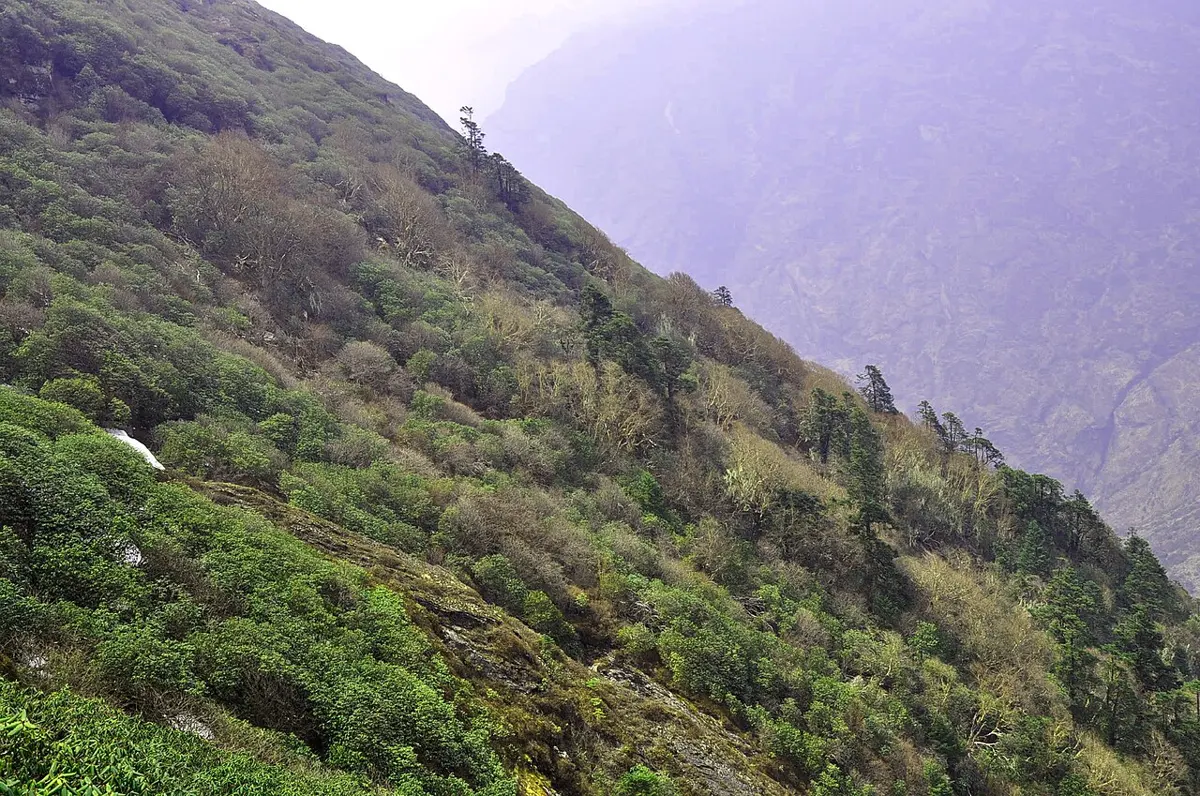
That height isn’t fixed. At the northwestern end of these mountains, in the Hindu Kush, the trees give out at 3,400 to 3,600 m, because the winters there are colder and the snow lies longer, even though summers are warmer. In southeast Tibet junipers grow at 4,900 m, the highest trees in the northern half of the world. And in much of the Himalaya the line is lower than the climate would put it, because people have pushed it down. Herders want pasture, and centuries of grazing and fire have cleared the top of the forest, most of all on the sunny south-facing slopes, where the treeline can sit 500 to 1,000 m below where it would otherwise be. On those slopes, nearly every treeline is one people made.
Above the trees comes the high pasture, and above that a thin zone of small plants between the grass and the permanent snow. It is bigger than it sounds: across the Himalaya and the mountains to the west, satellite pictures show five to fifteen times as much of it as there is glacier and snow. Between 1993 and 2018 it grew a little greener, most of all between 5,000 and 5,500 m.
The bands move as the climate warms, and Humboldt’s picture turned out to be a way of measuring it. In 2012 a team of scientists climbed Chimborazo again, 210 years after him, and found plants growing more than 500 m higher than his picture showed. Then a closer look at the old notebooks found a problem: apart from a few mosses and lichens, Humboldt and Bonpland had collected no plants on Chimborazo above about 3,600 m. The high part of the famous picture came mostly from another volcano, Antisana, and partly from Humboldt’s own best guess. On Antisana, where his notes can be checked, the highest plants have climbed between 215 and 266 m since 1802, about 11 m every ten years. That is about the speed plants are climbing on mountains all over the world. The Chimborazo team answered that Humboldt’s picture was always meant for the Andes as a whole, and that other old records still show a big climb there; the two teams still disagree about how much the plants have moved.
Some plants of these bands, from palms and cacti to rhododendrons, grow side by side in the center’s own Garden in Bhaktapur.
How people live in each
People live in every one of these zones except the permanent ice, and in each they have found ways to make a living from what the land gives. None of those ways says anything about what the people are like; what the land does is set the problem, and people have answered it in different ways in different places. Whether the land decides more than that is an old argument, and Chapter 18 has it.
In the rainforest, the problem is the soil. A common answer, in many tropical forests, is to clear a patch, burn it, grow crops for two or three years, then move to another patch and let the first grow back for many years. It is called shifting cultivation. The land left to rest isn’t wasted: people go back to it for firewood, timber, thatch, fruit and medicine. Along the Amazon, people did something more lasting. Between about 450 BCE and 950 CE they worked charcoal, bones, broken pots, compost and manure into the poor soil until it turned black and fertile, in places 2 m deep. In Portuguese it is called terra preta, black earth. It holds its goodness where the rain washes the soil around it bare, and some of the best soil in the Amazon was made by people.
In the hot deserts the problem is water, and the answer has often been to keep moving with animals that can live on scattered grazing. The Bedouin of Arabia and North Africa kept goats, sheep and camels, and lived mostly on their milk. Where the rain was unpredictable, a camp moved whenever the grass ran out, and where the winter rain was more reliable some planted grain along their routes. In the 1950s and 1960s large numbers settled in towns; in Syria, a drought from 1958 to 1961 ended the old way of life for many.
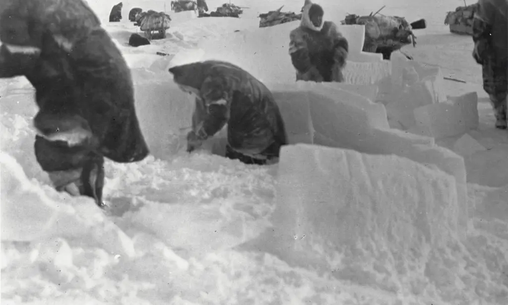
The polar lands are the emptiest. About 4 million people live in the Arctic, about half a million of them belonging to its Indigenous peoples. The best-known answer to the cold is the Inuit snow house, the igloo, and it is less common than people think. In Inuktitut, iglu means any house at all. Snow houses were used only in Canada’s central Arctic and around Qaanaaq in Greenland; other Inuit built houses of whalebone and hides and banked them with snow. Snow works because of the air trapped in it. With −45 °C outside, the inside of a snow house warmed by the people in it can be anywhere from −7 °C to 16 °C. In summer, when snow houses melt, families moved into tents of sealskin, and one tent took the skins of five to ten bearded seals.
Across the north of Europe and Asia, the answer has been reindeer, kept for meat, milk and skins and for travel. About 100,000 people herd reindeer around the Arctic today. In Norway’s herding lands only Sámi, the Indigenous people of the far north, have the right to do it; across Scandinavia about 6,500 of them do, with large herds and a lot of machinery, mainly for meat.
The mild lands set people the fewest problems. Their soils are fertile and their rain is reliable, and the black earth under the steppe and the prairie grows some of the biggest harvests on Earth. People have changed them more than any other zone. Taken across the whole world, more than three-quarters of the land that isn’t under ice shows the mark of people living on it and using it. Less than a quarter is still wild.
Mountains give people something no flat land can: several zones within a day’s walk. In the Andes, communities kept fields and herds at several heights at once: maize in the warm valleys between about 2,300 and 3,200 m, potatoes and quinoa above them up to about 4,000 m, llamas and alpacas on the cold grassland higher still, and coca on the wet forested slopes toward the Amazon. A community sent some of its people to live in the zones it lacked, or moved with its herds through the seasons. The anthropologist John Murra called it a vertical archipelago, a chain of islands stacked up a mountain, and it reached its height under the Inca.
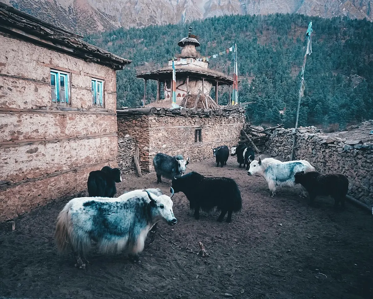
Himalayan herders do the same with their animals. At Wallanchoon, Hooker found many herds of yaks, and noted how they used the mountain through the year: in winter they grazed below 8,000 feet, about 2,400 m, because of the snow higher up, and in summer they found grass as high as 17,000 feet, about 5,200 m. The yak itself needs the cold. It couldn’t stand the damp heat of summer below about 7,000 feet, he wrote, and there it sickened and died within a few years.
The bands that Humboldt drew and Hooker counted are still there, a little higher than they were. The people of every zone keep finding new ways to live with them. Who those people are, the languages they speak and the beliefs they carry, is the next part of the story.
Found a mistake? Please tell us.