
Photographed at night from the International Space Station, Egypt looks like a flower made of light. The stem is a thin, bright thread running up from the south. Near the top it opens into a wide fan, and at the base of the fan sits a blaze, Cairo. All around it, for hundreds of kilometers on either side, there is almost nothing: dark desert.
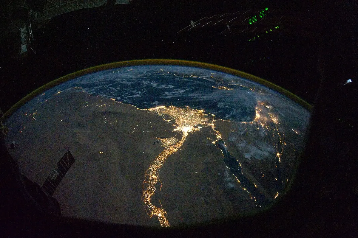
The thread is the Nile, and the lights are the towns and villages along it. The valley and the delta together make up less than 5% of Egypt’s land, and about 97% of Egyptians live there. The rest of the country is desert, and nobody can farm a desert without water.
Nepal has its own version, less dramatic from space but just as lopsided. The census of 2021 counted 29,164,578 people. Kathmandu district held 2,041,587 of them, packed about 5,169 to every square kilometer. Manang, behind the Annapurna range, held 5,658, about 3 to a square kilometer. Two districts of the same small country, and one is more than a thousand times as crowded as the other.
People don’t spread themselves over the Earth like butter on bread. They gather, in a few places, very thickly. Why they do, and how their numbers grow and stop growing, is where human geography begins. So does an old and uncomfortable question: does the land decide what people do?
Where people are
Our species, Homo sapiens, arose in Africa about 300,000 years ago. From there people spread, over a very long time, to every continent but Antarctica. In 2024 there were about 8.2 billion of us.
Most live low down. In the 1990s two researchers laid a map of where people live over a map of the land’s height, and found that a third of humanity lived within 100 meters of sea level, on about a sixth of the inhabited land. Line everyone up from the lowest to the highest, and the person in the middle lived just 194 meters up.
The reasons are mostly the ones the earlier chapters of this book have been about. People need water, and flat land and good soil to grow food, which rivers lay down on their plains. They prefer a climate neither too hot, too cold nor too dry, and they settle by coasts and rivers, which are roads for trade. Put all of those in one place, a warm, flat, watered plain near the sea, and people come in great numbers. Bangladesh, on the delta of the Ganga and the Brahmaputra, is one of the most crowded countries on Earth, with about 1,300 people to each square kilometer.
Nepal shows the same thing from top to bottom. Just over half of all Nepalis, 53.6%, live in the Terai, on the flat strip along the southern border, at 460 people to a square kilometer. The Mountain belt, high and cold, holds about 6% of the people at 34 to a square kilometer. The Hills come between.
But the land isn’t the whole story, even here. Kathmandu district isn’t crowded because its soil is better than Chitwan’s. It is crowded because the capital is there, with the government, the jobs, the colleges and the airport. Between 2011 and 2021 its neighbor Bhaktapur grew faster than any other district, by 3.35% a year, while Ramechhap, in the hills to the east, lost people. The flat valley floor made the city possible, but the jobs are what keep the buses full every morning.
Reading a density
The usual way to measure crowding is simple: count the people and divide by the area. That gives the population density. Nepal’s, in 2021, was 198 people to a square kilometer, up from 180 ten years before.
A single number like that hides a great deal. Egypt’s density is about 117, lower than Nepal’s, which suggests an Egypt with room to spare. The night photo says otherwise. Nearly all those people are squeezed onto a narrow ribbon of farmland, and the average spreads them, on paper, across a desert where almost nobody lives.
So geographers use other divisions too. Divide the people by the land that can be farmed, instead of by all the land, and you get what is called the physiological density: how many mouths each square kilometer of fields has to feed. Only about 3% of Egypt can be farmed, and its physiological density comes to about 3,600 people for each square kilometer of farmland. Nepal’s comes to about 1,600, since only about an eighth of its land is farmland. Bangladesh, where more than half the land is fields, comes to about 2,200, between the two, even though its ordinary density is more than six times Nepal’s. A third measure counts only the farmers, divided by the farmland: the agricultural density, which says how much land each farming family has to work with.
None of these is the right one; each answers a different question. And every one of them is an average, so the bigger the area, the more it hides: Nepal’s 198 contains both Kathmandu’s 5,169 and Manang’s 3. A density is worth only as much as knowing what area it was measured over, and what that area contains.
Births and deaths
Nepal’s first census, in 1911, counted 5,638,749 people. In 1930 there were fewer, 5,532,574. Then the numbers began to climb, slowly at first and then fast. Between 1971 and 1981 it grew by 2.6% a year, adding three and a half million people in ten years. By 2021 there were more than five times as many people as in 1911, and yet the growth had slowed to 0.92% a year, the slowest since the 1920s, when the count had actually fallen.
Why would a population sit still for decades, then shoot up, then slow down? The same thing has happened, or is happening, in nearly every country on Earth. It comes from a shift in births and deaths called the demographic transition, and it has a simple shape.
At first, many babies are born, and many people die, many of them as small children. Births and deaths roughly cancel, and the population hardly grows. This is how humanity lived for almost all of its history.
Then deaths fall. Clean water, vaccines, medicines and more food keep more children alive and let adults live longer. But births don’t fall at the same time. Families go on having as many children as before, and now most of those children survive. The gap between births and deaths opens wide, and the population shoots up.
Later, births fall too. When parents can expect their children to live, they tend to have fewer. Children who go to school instead of working in the fields cost a family more and earn it less, and women with more schooling and more say in their own lives tend to have fewer children and later. The gap closes again.
At the end, births and deaths are both low, and the population grows slowly, stops, or begins to shrink.
Take Sweden. Its deaths began to fall around 1800. Its births stayed at the old level until the 1860s, and the gap between them didn’t close until the first half of the twentieth century: the whole journey took well over a century. Nepal’s numbers since 1960 show the same journey, made much faster.
In 1960, about 45 babies were born in Nepal for every 1,000 people, and about 25 people died. Deaths then fell steadily, year after year, to about 7 by the mid-2000s. In 1960 a newborn could expect to live about 39 years. Today it is about 71. Births, meanwhile, stayed high for a long time: still about 37 per thousand in the mid-1990s. That stretch, when deaths had fallen and births hadn’t yet, is where the gap between the lines is widest. Then births fell quickly, to about 19 per thousand by 2024. In the early 1980s a Nepali woman had on average more than six children. By the census of 2021, it was 1.94.
That number matters because of another one: 2.1. If each woman has about 2.1 children, each generation just replaces the one before. Nepal is now below it. The population hasn’t stopped growing yet, because a large share of Nepalis are of an age to have children, but it is heading that way. Its people are getting older too: the share aged 15 to 59 grew from 57% in 2011 to 62% in 2021, while about 28% were 14 or younger and about 10% were 60 or older.
The census shows something the neat diagram doesn’t. It found 2,190,592 Nepalis living abroad, more than four in five of them men. Births and deaths aren’t the only things that change a population: people also move, a story for later in this book.
The world as a whole is somewhere in the middle of the same journey. More than half of all countries now have fewer than 2.1 children per woman, and in 63 countries the population has already peaked. The UN expects the world’s population to keep rising for another fifty or sixty years, to about 10.3 billion in the mid-2080s, then to fall a little.
The transition is a description of what has happened, not a law that has to happen. It was drawn from the history of north-western Europe, and other countries fit it only roughly. Many went through it far faster than Europe did, often with governments pushing smaller families, as China did with its one-child policy. The model also leaves out people who move, and nobody knows where it ends, since only a few countries have gone far enough to show what comes after. But it says something about Nepal: what changed its numbers was not its rivers or its land, which stayed the same, but its schools, its health posts and its families’ choices.
Does the land decide?
This book has been telling a long chain of cause and effect: the plates raise the mountains, the mountains squeeze out the rain, the rain makes the rivers, the rivers lay down the plains, and people crowd onto the plains. It is easy to keep going: the climate makes the character of a people. That step is where geography once went badly wrong.
Nepal’s geography course names three positions in the argument. नियतवाद (niyatavāda), determinism, says that nature decides: the land and the climate shape what people do, and even what they are like. सम्भववाद (sambhavavāda), possibilism, says that nature only offers choices, and people decide. नवनियतवाद (navaniyatavāda), neo-determinism, takes a path between them. Each has its people.
Friedrich Ratzel, a German who trained as a zoologist, built the first big system of human geography in the 1880s, and he described peoples and states the way a zoologist describes animals in their habitats. He thought of a state as something like a living thing that needed room to grow, and in 1901 he wrote an essay about Lebensraum, “living space”. He was more careful about cause and effect than his followers, but after his death the idea was twisted into a case for conquest, and in Nazi Germany it became a slogan for taking other people’s land.
His American student Ellen Churchill Semple carried his ideas into English. Her book of 1911 opens with a sentence that sums up the whole school: “Man is a product of the earth’s surface.” The earth, she wrote, has “entered into his bone and tissue, into his mind and soul”: mountains give people legs of iron, and the coast leaves the legs weak but builds strong arms for rowing. She was careful in places, and in her preface said she avoided the word “determinant”. But later in the same book she says that the peoples of northern Europe are energetic and serious, those of the Mediterranean easy-going and emotional, and that in the peoples of the equatorial belt these qualities “degenerate into grave racial faults”. That isn’t geography. It is the prejudice of her time, dressed up as geography.
Ellsworth Huntington, at Yale, went further with climate. In Civilization and Climate (1915) he drew one map of the climates he believed best for human energy and another of the most “civilized” places, and showed that they matched. From 1934 to 1938 he also led the American Eugenics Society, which campaigned to “improve” humanity by controlling who had children. A geographer who admired much of his work later called him “extremely Eurocentric”.
These weren’t harmless mistakes. In an age when European countries ruled much of Asia and Africa, a theory that said hot climates made people lazy and cool ones made them fit to rule was very convenient. It turned empire into a law of nature: the rulers were simply what their climate had made them, and so were the ruled. Geographers who have studied the period say plainly that determinism served empire and racism, and that it gave nature a power to cause things that no evidence supported.
The answer came from France. Paul Vidal de la Blache, who died in 1918, studied how each region’s people had built their own way of life, their genre de vie, from what their land offered: different people, in similar places, built quite different lives. “It is man,” he wrote, “who, in bending those resources to his own ends, brings to light the geographic identity of a country.” His follower, the historian Lucien Febvre, gave the idea its name, possibilism, in a book of 1922, and summed it up in a line: “There are no necessities, but everywhere possibilities; and man, as master of the possibilities, is the judge of their use.”
The middle way is usually credited to Griffith Taylor, an Australian geographer whose story has a twist. In the 1920s Australia was full of talk of filling the continent’s empty interior and north with farms and millions of white settlers. Taylor said no: the interior was desert and would stay nearly empty, and the future millions would live “precisely where live the millions of today”. He was attacked in the newspapers as a pessimist and unpatriotic (a few years earlier, a school textbook of his had been banned in Western Australia), and in 1928 he left for Chicago. He turned out to be right. Australia now has about 27.6 million people, an average of 3.6 to a square kilometer, and nearly 19 million of them live in its capital cities, all but one of them on the coast. Nature, in his view, set the limits and people chose within them, which is roughly what Nepal’s course means by नवनियतवाद. He also questioned the White Australia policy, which kept out immigrants who weren’t white. Yet the same Taylor wrote books, among them Environment, Race and Migration (1937), sorting humanity into races and tracing each to the lands and climates he believed had shaped it, ideas that science has since left behind. He was right about the desert and wrong about race.
Same land, different lives
There is a way to put the question to the test: find one piece of land, and see whether everyone on it lives alike.
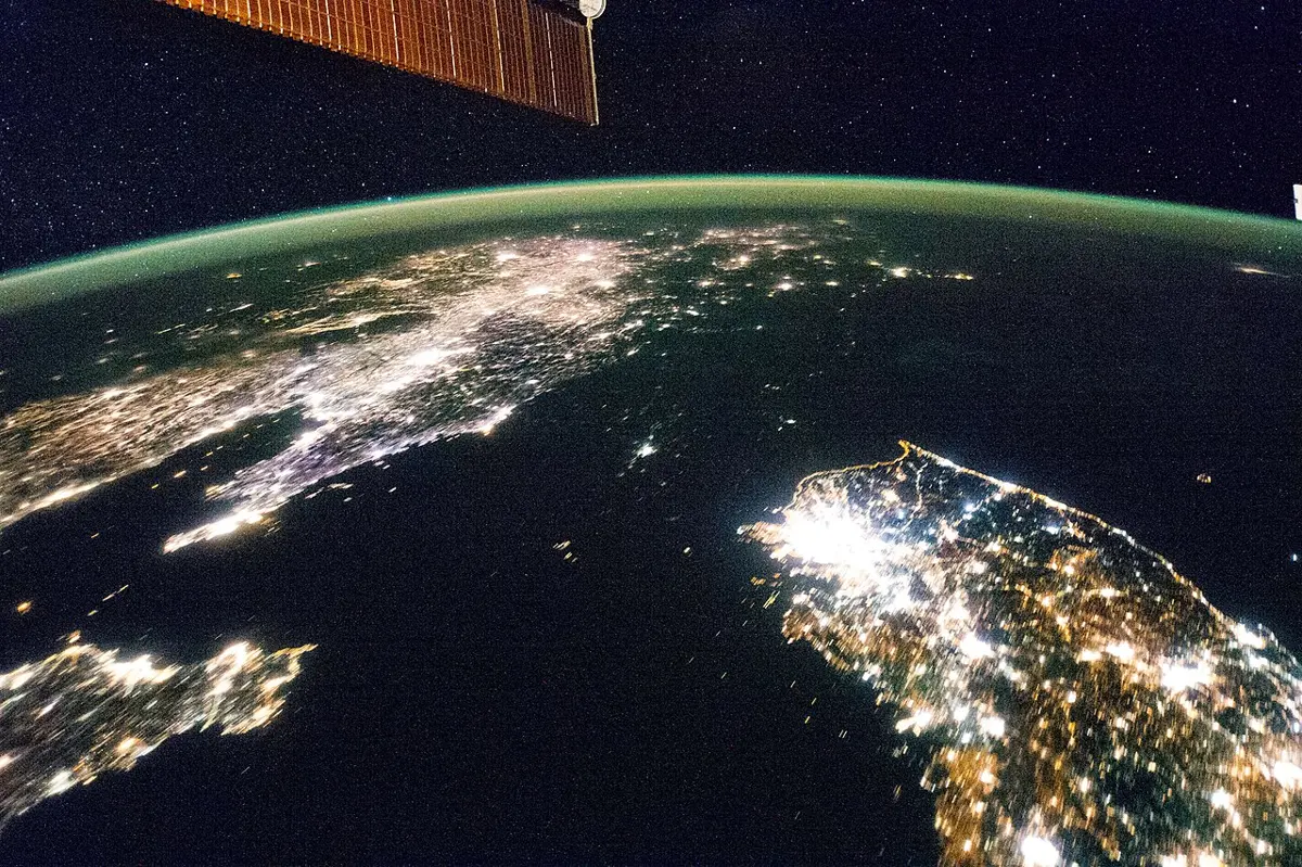
The Korean Peninsula was one country for centuries. At the end of the Second World War, in 1945, it was split along a line of latitude, the 38th parallel, and in 1948 the two halves became two countries with different governments and different economies. From space at night, the south is a sheet of light, and the north is so dark that it looks like sea, with its capital a small island in the middle. In 2014, the year of the photo, the World Bank counted about 10,500 kilowatt-hours of electricity for each South Korean and about 700 for each North Korean, some fifteen times as much. The two halves share their mountains, rivers and climate. What differs is the path each has taken since 1945.
Bandipur makes the same point on a small scale: its ridge never changed, but the road moved down the hill, and the town’s fortunes moved with it.
None of this means the land doesn’t matter. It matters a great deal. Manang’s high, cold valleys can’t feed as many people as the Terai’s warm plain, and no government can make Egypt’s desert as crowded as the Nile’s banks without bringing the river to it. The land sets what is easy, what is hard and what costs too much. Nepal’s school books describe two ways people live with it: they fit themselves to it, समायोजन (samāyojana), with warm clothes, the right crops and houses built for the weather, and they change it, परिवर्तन (parivartana), with terraces, canals, dams and cities. Both happen everywhere, all the time, and which a society does more of depends on its tools, its money and its choices.
That is roughly where geographers stand today: the land sets limits and offers openings, and people choose within them. Courses for students now present the story as one that moved from determinism to possibilism. But the old argument hasn’t quite gone away. Jared Diamond’s Guns, Germs, and Steel (1997) argued that the continents’ plants, animals and shapes, not any difference in their peoples, explain why some societies came to conquer others. That is a long way from Semple: it puts the cause in the land precisely so as not to put it in people. Its critics, geographers among them, answered that it repeats determinism’s old mistake of letting nature explain too much. The argument goes on.
So the chain of cause and effect in this book has a weak link, and it is the last one. The land offers people a set of possibilities, some generous and some mean, and then people choose among them, in ways no map of rock or rain can predict. What the choices have looked like in the world’s hot lands, its mild ones and its cold ones is the next part of the story.
Found a mistake? Please tell us.