
In 1853, and again in 1856, a British army engineer named Alexander Cunningham walked over the mounds of Harappa, a village beside the Ravi river in what is now Pakistan’s Punjab. The mounds were huge, the highest about 60 feet, some 18 meters, above the fields, and they were made of old brick. He could trace flights of steps, and the massive walls of buildings. When he came back in 1872, as head of the new Archaeological Survey of India, the walls were gone. A railway had been laid from Lahore to Multan, and its contractors had carted off Harappa’s bricks to bed the track. There had been enough of them, Cunningham wrote, for about a hundred miles of railway.
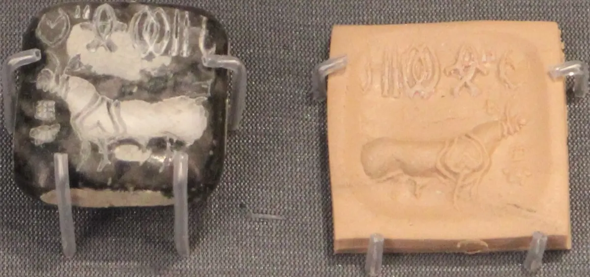
He dug a little anyway and found “very little worth preserving”. The strangest thing he saw was a small black stone seal that belonged to a Major Clark. On it was a bull with no hump, and above the bull, six signs that he couldn’t read. They were certainly not Indian letters, he decided, and since Indian cattle have humps, the seal must have come from somewhere else. He was wrong on both counts. The bricks under the railway and the little seal were the remains of one of the first civilizations in the world, and it took another fifty years for anyone to see it.
In the 1920s Indian archaeologists dug properly: Daya Ram Sahni at Harappa and R. D. Banerji at Mohenjo-daro, more than 600 kilometers to the south-west in Sindh. Both sites turned out to hold the same kind of city, with the same bricks and the same seals. On 20 September 1924 the Survey’s director, John Marshall, announced it in the Illustrated London News. Until then, he wrote, knowledge of India’s past had reached back hardly further than the 200s BCE. Now it looked as if they were “on the threshold” of a discovery as big as the ancient cities of Greece.
Here is the whole story in a few lines. Between about 2600 and 1900 BCE, cities and towns stood all over the plains of the Indus and its neighboring rivers, in today’s Pakistan and north-west India. They were planned, with straight streets, covered drains and bricks of the same proportions everywhere. They used one set of weights and wrote in one script, which nobody can read today. More than 1,500 of their settlements have been found, over a larger area than ancient Egypt and Mesopotamia together. Yet they left no great palaces, no temples that anyone can point to and no kings’ tombs, and nobody is sure who ran them. After about 1900 BCE the cities shrank, writing went out of use and people moved east. Why it ended is still argued.
Cities laid out in advance
The best place to see one of these cities is Mohenjo-daro, beside the Indus in Sindh. It covered about 240 hectares, though only about a third has ever been dug. A high mound stood on the west, and a larger lower town spread out to the east. Nobody counted the people, but estimates run to some tens of thousands.
Its streets ran north to south and east to west. The main ones were up to 9 meters wide, room for two ox carts to pass, and narrower lanes branched off them into the neighborhoods. Most houses were built of baked brick, many of them two stories high, around a central space with rooms on all sides. Doors usually opened onto the side lanes, and windows were kept to the upper floor.
What everyone notices is the water. Almost every house had its own bathing area, a floor of bricks laid on edge and fitted tight so it wouldn’t leak. Many had a toilet beside it, an old storage jar sunk into the floor with a hole in its base. Dirty water ran out through small drains into brick-lined drains along the street, some of them covered, and from there out of the city. People got their water from wells lined with wedge-shaped bricks made for the purpose. So many have turned up in the parts already dug that Michael Jansen, a scholar who has spent years on the city, worked out that Mohenjo-daro may have had more than 700 of them.
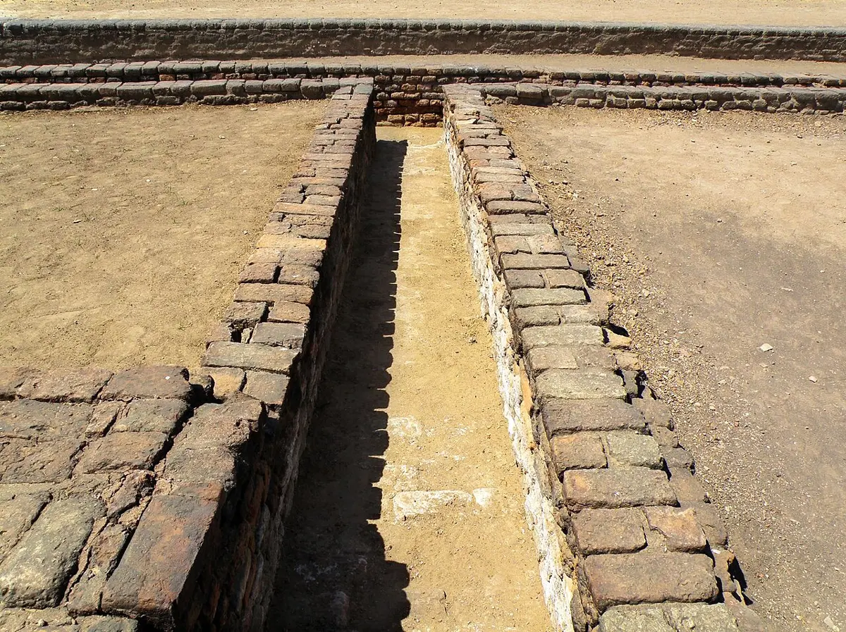
None of this ran by itself. Drains clogged and streets filled up with broken pots and rubbish, so every so often people built new drains and new street surfaces on top of the old ones. At Harappa some neighborhoods kept their drains clean while others let them fill with refuse, and even dead animals, before someone rebuilt them. Over the centuries this rebuilding raised the cities far above the plain, 18 to 20 meters in places, which is why they were mounds when Cunningham saw them.
The bricks themselves tell the most surprising story. Wherever these people built, from Punjab to Gujarat, their bricks kept the same proportions, 1 to 2 to 4 for thickness, width and length, for some 700 years. A house brick was about 7 by 14 by 28 centimeters, a bigger brick for city walls about 10 by 20 by 40.
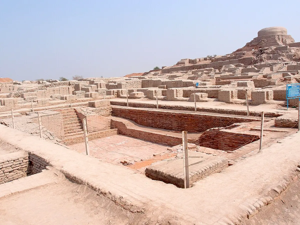
On top of the high mound at Mohenjo-daro is the most famous building of all, the Great Bath. It is a pool about 12 meters long, 7 wide and 2.4 deep, with a wide staircase at each end. Its floor and walls are bricks set tight in gypsum plaster, and behind the walls is a thick layer of bitumen, natural tar, to keep the water in. A well in a room beside it may have helped fill it. Nobody knows exactly what it was for, but most scholars think it was used for rituals in which water was meant to purify the people bathing.
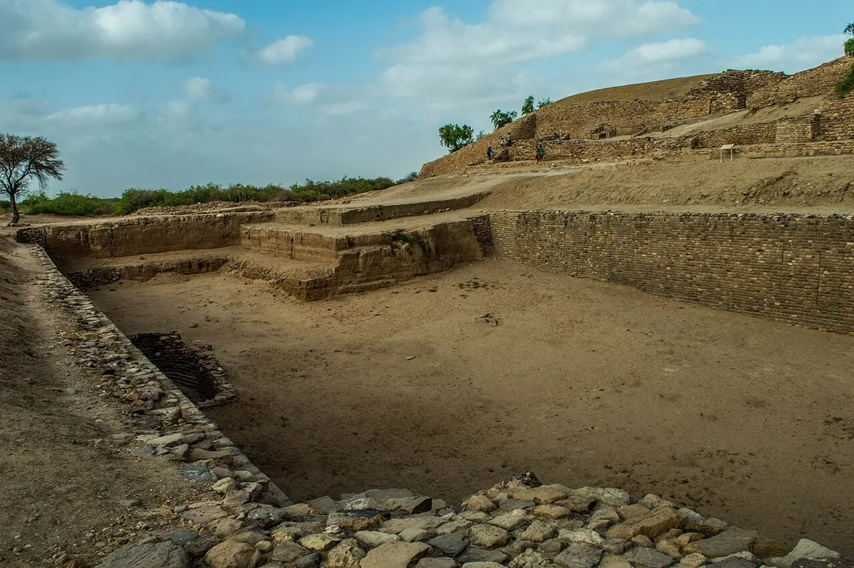
Not every city was the same. Harappa covered about 150 hectares and had far fewer wells. Dholavira, on the island of Khadir in the salt waste of the Rann of Kachchh in Gujarat, was built largely of stone. Its water came from two streams that ran only in the monsoon, so its people built dams and a chain of great stone reservoirs inside the city walls to catch every drop. Rakhigarhi in Haryana, the biggest site found in India, may have been the largest of them all. Each of these four covered more than 100 hectares in the cities’ best centuries, and a fifth city, Ganweriwala, nearly as much.
Farmers, makers and traders
The cities rested on farming. In winter people grew wheat and barley, with pulses, peas and sesame, and after the summer monsoon they could grow millets and other crops. Rice was grown in Gujarat but was not common on the Indus. They kept humped and unhumped cattle and water buffalo, then sheep and goats. And they grew cotton, which they spun and wove into cloth, as they did wool.
Unlike the farmers of Mesopotamia, they dug no great canals. Their fields drank the summer floods and the rain, and the winter crops grew in soil the floods had left wet. That will matter later in the story.
In the cities lived people who made things for a living: potters, metalworkers who cast copper and bronze, shell carvers who cut bangles, and bead makers who could drill a hole down the middle of a long, hard carnelian bead, a red stone, with drills made for the job. Some goods were made in several qualities, so the same bangle might be terracotta for one person, shell or copper for another and gold for a third. At Harappa, more than 800 kilometers from the sea, people ate dried sea catfish carried up from the coast.
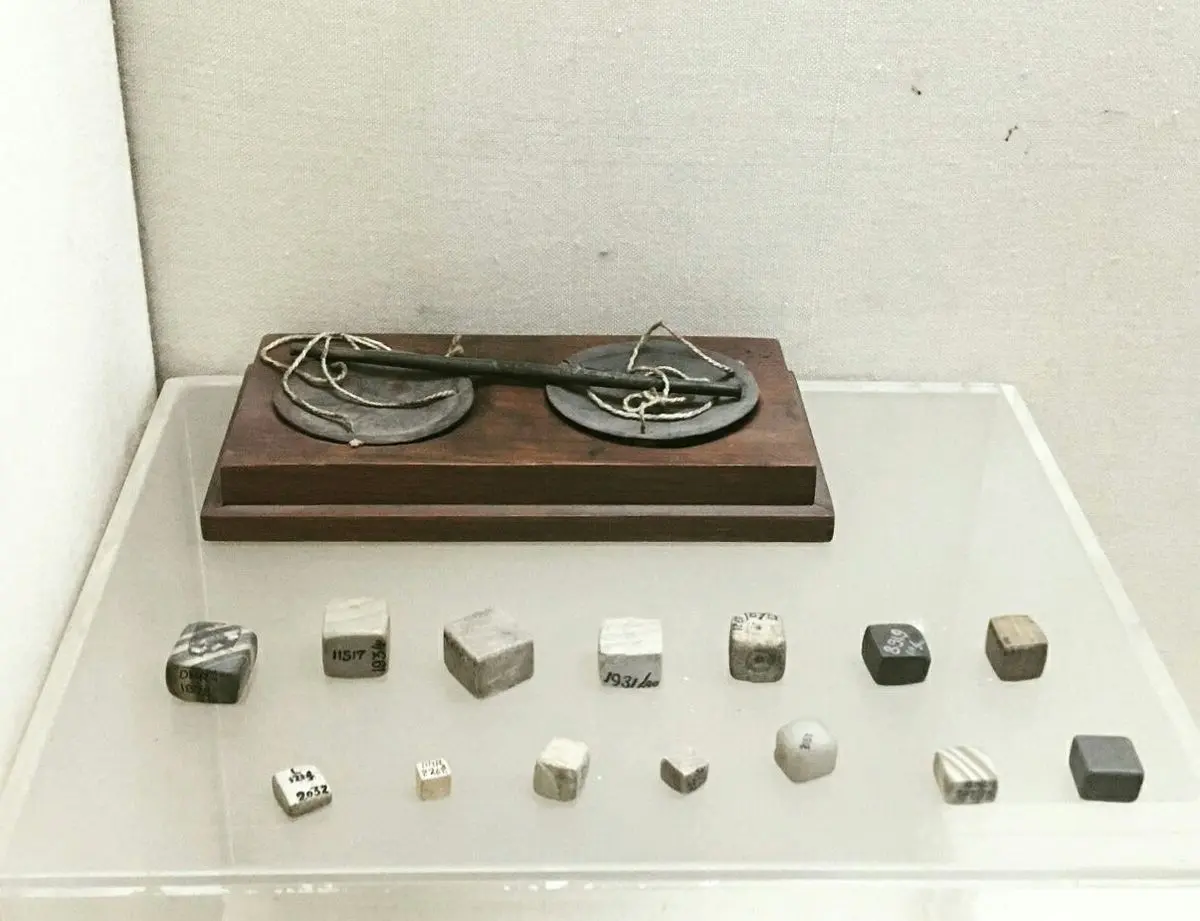
They weighed what they traded with small cubes of stone, most of them cut from a banded gray stone called chert, and the weights are as standard as the bricks. The smaller ones double each time, 1, 2, 4, 8, 16, 32 and 64 times the smallest, which weighs a little under one gram. Above that they follow a decimal pattern. The same set turns up at site after site, mostly near city gates, where they may have been used for collecting taxes, and long after the cities had gone, weights in South Asia kept to the same system.
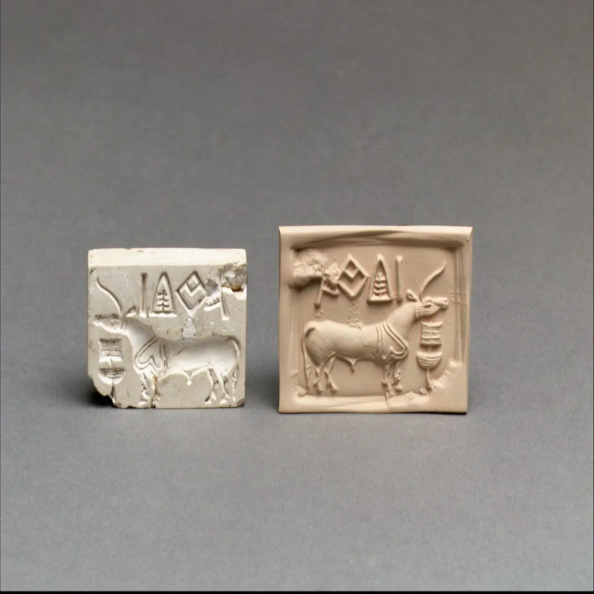
Goods left the cities in bundles sealed with clay, and the clay was stamped with a square seal like Major Clark’s, usually carved with an animal and a line of writing. The seals and weights traveled far. They have been found around the Persian Gulf and in Mesopotamia, whose records speak of ships from a land called Meluhha, which most scholars take to be the Indus. Red carnelian beads drilled the Indus way lay in the graves of the rulers of Ur, in Iraq, from about 2600 BCE. Oddly, the trade left almost nothing from Mesopotamia in the Indus cities. Whatever came back may have been cloth, food or raw metal, things that rot or get melted down.
Whether the cities had ports of their own is less clear than many books say. At Lothal, a small town near the Gulf of Khambhat in Gujarat, the excavators found a great brick-lined basin beside the town and took it for a dock where ships came in from the sea. Others have doubted it. The way in looks too narrow and shallow for boats, they say, and the pierced stones on its floor, taken for anchors, could be the counterweights of poles for lifting water. A tank to store water is the main other idea, and it has problems of its own. What the basin was for is still an open question.
Who was in charge?
This is where the Indus cities puzzle people. In Egypt the kings built pyramids and carved their names and victories everywhere. In Mesopotamia the great temples towered over the cities, and kings boasted of their wars. In the Indus cities nobody has found a building that is clearly a palace or a temple, or a grave rich enough to be a king’s. A great brick platform at Mohenjo-daro was long called the “granary”, but nobody has found any sign that it ever held grain. And there are no pictures of battles.
The most famous carving from Mohenjo-daro, a bearded man in a patterned cloak, only 17.5 centimeters tall, was nicknamed the “Priest-King” by the first excavators. It is still called that, though nobody knows whether he was a priest, a king or neither. Jonathan Mark Kenoyer, an American archaeologist who has dug at Harappa since the 1980s, thinks such statues may show the heads of clans.
So were these cities equal, peaceful places? Not that either. Houses were of different sizes and quality, and at Dholavira the most heavily guarded part, which its excavators called the “castle”, stood apart from the rest of the city. The people buried in the cemeteries had better health and richer pots and ornaments than most, and they were only a small share of the population. Big cities had massive walls, too, with narrow gates where traffic could be watched. Kenoyer thinks the cities were run by groups of powerful people, landowners, merchants and religious leaders, rather than by one king, and that the walls served to control trade as much as to keep out enemies, since no major city shows signs of being attacked. Asko Parpola, a Finnish scholar of the Indus script, points out that there are a few warriors in Indus art, a copper figure of a man with a spear and a seal of two men about to spear each other, and that some older towns may have been burned when the cities’ way of life spread. The fairest answer is that a large, unequal society ran for centuries without leaving us any sign of a king, and that nobody knows how.
Its religion is just as hard to read. People made small clay figures of women and men in elaborate headdresses, which may be gods. Seals show a figure seated with legs folded, ceremonies under a pipal tree and processions with animals. Most of the dead were buried, laid in a pit with the head to the north, often in a wooden coffin or a shroud, with pots and ornaments for the next life. What any of it meant to the people who did it, nobody can say, because nobody can read their writing.
Writing that nobody can read
About four to five thousand short inscriptions survive, most of them on seals and their clay impressions, on small tablets and scratched on pots. The script has about 400 different signs. That is far too many for an alphabet and too few for a script with one sign for every word, so many scholars think each sign stood for a word or a syllable, as in early Mesopotamia. It was mostly written from right to left.
Three things make it so hard. The inscriptions are short, five signs on average, and the longest on a single surface has only seventeen. Nobody knows what language they wrote. And there is no bilingual, no stone carrying the same words in the Indus script and a script we can read, like the Rosetta Stone that unlocked Egypt’s writing.
People have tried for a hundred and fifty years. More than a hundred decipherments have been published, and none has convinced other scholars. The most worked-out are by those who think the language was an early form of the Dravidian family, whose languages, Tamil, Telugu, Kannada and Malayalam among them, are spoken today mostly in south India. Their famous starting point is the fish sign. In Dravidian languages the word मीन (mīn) means both “fish” and “star”, so the fish may have been written to mean “star” or a god of the sky, the way a picture of an eye can stand for the word “I”. Iravatham Mahadevan, the Indian scholar who made the standard list of the inscriptions, called this “a very attractive theory”, and added that it had not been proved and couldn’t be without a bilingual. Others have tried reading the signs as Sanskrit or other languages, and those readings haven’t convinced other scholars either.
Some go further and doubt it is writing at all. In 2004 three scholars, Steve Farmer, Richard Sproat and Michael Witzel, argued that the signs were symbols, like the badges of families or gods, that didn’t spell out words. In 2009 a team led by the computer scientist Rajesh Rao, with Mahadevan, compared the order of the signs with real languages and with symbol systems, and found the Indus signs behaved more like languages. Sproat answered that their test couldn’t tell writing from other symbols. Most archaeologists still think it is writing. And it still matters to people: in January 2025 the Chief Minister of Tamil Nadu offered a million US dollars to whoever deciphers it in a way archaeologists accept. Nobody has claimed it.
How the cities ended
From about 1900 BCE the great cities were losing people. Mohenjo-daro was abandoned. Settlements grew smaller and their styles more local, the seals and the script stopped being made, and the stone cube weights fell out of use. Many villages kept going, and people kept making pots, bricks and beads in the old ways for centuries more. But people were leaving the old heartland, and more settlements appeared to the east, toward the plains of the Ganga and the Yamuna, and south in Gujarat. Archaeologists call these centuries, to about 1300 BCE, the Late Harappan. The towns of Dholavira tell the same story in miniature: the city shrank to a town, then its people left, and later newcomers built round huts on the ruins.
For a long time the favorite explanation was an invasion. The British archaeologist Mortimer Wheeler pointed to skeletons found lying in the streets and houses of Mohenjo-daro, linked them to the god Indra, called “fort-destroyer” in the Rigveda, and wrote that “Indra stands accused”. In 1964 the American archaeologist George Dales went back over the evidence. In nine years of digging, about 37 skeletons had been found that might belong to the city’s time, and they couldn’t be shown to be from one moment; some came from earlier levels, some were careless burials. There were no burned forts, piles of weapons or bodies of attackers, and nobody had died defending the high mound. The massacre, he wrote, was a myth. It no longer explains the end of the cities, although whether new people arrived in the north-west in the centuries after is a separate question, taken up with the Vedas.
What most researchers look at now is water. The cities were built when the rain was already becoming scarcer, and the monsoon kept weakening. A study led by the geologist Liviu Giosan in 2012 found that the summer floods the fields depended on grew less reliable, and farmers turned to hardier crops like millets. The rivers between the Indus and the Yamuna, the system known as the Ghaggar-Hakra, ran only on monsoon rain, and as the rains failed they dried up or flowed only part of the year. With no big canals to fall back on, people who had always farmed with the floods did what farmers could do: they moved toward the wetter east, and the cities lost the people and the harvests that had kept them going.
Climate alone doesn’t settle it. The Indus itself, fed by Himalayan snow, kept flowing, and people stayed along it. Some archaeologists think people also turned away from the ideas that had held the cities together. Most scholars now think several of these causes worked together over a few centuries, and they don’t agree on which mattered most.
The Ghaggar-Hakra has a second argument of its own. Some scholars identify it with the सरस्वती (Sarasvati), the great river of the Rigveda, so whether it was a great Himalayan river in the cities’ time matters to people for more than its mud. A study published in 2017 found that the Sutlej, a Himalayan river, once flowed along its bed but changed course about 8,000 years ago, long before the cities, which grew up beside a river fed only by the monsoon. Others read the evidence differently, and the river’s history is not settled.
Who they were
For most of the last century, no one could say anything certain about the Indus people’s ancestry. Then, in 2019, a team of Indian and American scientists published the first DNA read from an Indus skeleton, a woman buried in the cemetery at Rakhigarhi. Of 61 skeletons tried, only hers gave enough old DNA to work with, from the bone of the inner ear.
Her ancestry was a mix of two very old lines. The larger part came from people related to the ancient people of the Iranian plateau, but from a branch that split off from them before farming began there. The rest came from ancient South Asian hunter-gatherers. People with much the same mix had turned up as outliers at two trading towns in Iran and Turkmenistan that dealt with the Indus, as if they were Indus people living abroad. She had none of the ancestry that came with herders from the steppes of Central Asia, which later spread across northern South Asia in the first half of the second millennium BCE, after the cities had begun to decline. Most people in South Asia today descend largely from a population like hers, mixed in different proportions with others.
The scientists themselves warned that one woman, or even twelve people with her kind of ancestry, can’t describe a whole civilization. And her DNA can’t say what language she spoke or what she believed. The same result has been read in opposite ways. The geneticists who wrote the papers saw it as support for the view that Indo-European languages like Sanskrit came into South Asia later, with the steppe ancestry. The archaeologist who led the excavation, one of the authors too, told reporters that it showed the Indus people were the Vedic people, something neither paper says. That argument belongs to the Vedas, and it is where this book will take it up.
The Indus cities show that a civilization didn’t need a god-king. For seven centuries, across an area larger than Egypt and Mesopotamia together, people built cities to a plan, with streets for carts, drains in every neighborhood, bricks of one shape and weights of one set, and they did it without leaving behind a king’s name, a palace or a picture of a war. Their writing is still unread, so we see them only from outside, through what they built and threw away. Their cities ended slowly, as the rains and rivers changed and people moved east, not in one great battle. And the people didn’t vanish. Their descendants are much of the population of South Asia today. Far to the east, on another great river, another civilization was taking shape, and there the writing can be read.
Found a mistake? Please tell us.