
In 1936 a young architect named Tatiana Proskouriakoff went to the ruins of Piedras Negras, in the forest of Guatemala, to draw them for a museum in Philadelphia. She had been born in Tomsk, in Russia, and trained as an architect in Pennsylvania. Her job was to make pictures of what the buildings had looked like. Years later, studying the city’s carved stones, she noticed a pattern in their dates.
The stones of Piedras Negras stood in groups. Each group began with a tall carved slab, a stela, showing a figure seated in a niche high up. On it, the earliest date carried a sign like a frog standing on its head, and a later date a sign that scholars had nicknamed the toothache glyph. She found seven such groups, and saw what they meant. The frog marked a birth, the toothache a man becoming king, and the stones were the life stories of real rulers, one after another. Most experts of the day thought the carvings recorded the stars and the calendar, and that the figures in the niches were gods. Her paper of 1960 showed otherwise: the stones were history.
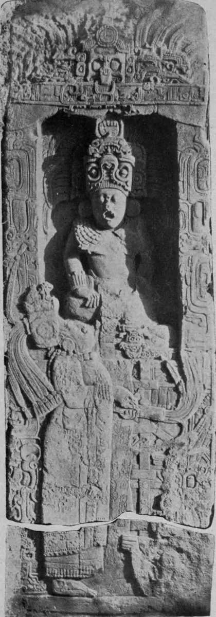
The people who carved those stones lived in a part of the world that had gone its own way for thousands of years, with almost no contact with Asia, Africa or Europe. Everything they made, the crops, the numbers, the calendars, the writing, the cities and the roads, they made on their own. This chapter is about some of it: the Maya of southern Mexico and Central America, the cities of the Valley of Mexico, a city on the Mississippi, and the Inca of the Andes, mountains with a great deal in common with ours.
A world on its own
People first came into the Americas from Siberia during the last Ice Age, across land that is now under the sea. When the ice melted, the sea covered the way back. From then on the two halves of the world grew up apart, each with its own plants, animals and diseases, and for all those years almost nothing crossed between them.
So the peoples of the Americas invented farming for themselves, from their own wild plants. In the Balsas River valley of southern Mexico, people were grinding an early maize on their stone tools by about 8,700 years ago. Its wild parent, a grass called teosinte, has a little ear of six to twelve seeds, each shut inside a hard case: nothing like a cob. Over thousands of years farmers turned it into the plant whose cobs now dry on house walls all over Nepal’s hills. In the Andes, near Lake Titicaca, other farmers tamed the potato about 8,000 years ago, and the Andes still grow some five thousand kinds.
They tamed animals too, but very few. In the Andes the llama, a cousin of the camel, carried loads, but there were no horses, cattle or oxen anywhere in the Americas, so nothing pulled a plow or a cart. Most of what the Americas built, they built with human hands and human backs.
The Maya, in their own words
The Maya were never one empire. They lived in dozens of cities in the lowland forests of southern Mexico, Guatemala and their neighbors, each with its own king, its allies and its enemies. Two of them, Tikal and Calakmul, were at times the strongest, and the others lined up behind one or the other. Their great age, which archaeologists call the Classic period, ran from about 250 to 900.
For a long time the forest hid how many of them there were. In 2016 a survey plane flew over northern Guatemala with a laser that sees between the leaves to the ground, and mapped more than 60,000 structures in about 2,100 km²: houses, temples, walls, raised roads and farmed fields, many of them never seen before under the trees. From those maps, the people who studied them reckon that somewhere around 7 to 11 million people lived in the central Maya lowlands between about 650 and 800, at the top of earlier guesses.
The Maya counted in twenties, perhaps because fingers and toes make twenty. A dot was one, a bar was five, and a shell was zero, so nineteen was three bars with four dots on top. For bigger numbers they stacked levels upward, each worth twenty times the one below, the way our 33 means three tens and three ones. Their 33 is one dot on the upper level, one twenty, above the sign for thirteen. The shell mattered. With a zero to hold a place, a number’s position gives its size, and the Maya and their neighbors worked that out on their own, with no help from India, where the digits we use today were born.
The same counting made a calendar. Besides a year of 365 days and a sacred round of 260, the Maya kept the Long Count, which numbered every single day from a starting day that falls, in our calendar, in August 3114 BCE. Its places counted days, then twenties of days, then years of 360 days (the one place that steps by eighteen instead of twenty, to come near a real year), then twenties and four-hundreds of those years. A date on a stela said exactly which day a king was born or crowned, which is what let Proskouriakoff line the lives up.
When the count rolled over to a round new number on 21 December 2012, newspapers around the world said the Maya had predicted the end of the world. They hadn’t. The one Maya inscription known to mention that day says nothing about an ending, and on the day itself crowds gathered at the old Maya cities to greet the sunrise.
The Maya wrote books too, on long strips of bark paper folded like a fan and painted with signs. Almost all of them are gone. In 1562 a Spanish friar, Diego de Landa, burned a pile of them at Maní, in Yucatán, 27 books by one count, along with many thousands of images of gods. Only four Maya books survive anywhere in the world.
Yet the same Landa left the key to reading them. He asked a Maya writer for the Spanish letters, and wrote down the signs he was given as an alphabet. It wasn’t one. Asked for the letter b, which in Spanish is said “be”, the writer drew the sign for the syllable be. In 1952 a young Russian scholar, Yuri Knorozov, saw that Landa’s list was made of syllables, and that the script mixed signs for whole words with signs for sounds. The leading Maya expert of the day, Eric Thompson, would have none of it, and many followed him. But Proskouriakoff’s dates showed what the inscriptions were about, and Knorozov’s syllables showed how to read them. At a small meeting at Palenque in 1973, two young scholars worked out most of that city’s line of kings within hours. Today most Maya inscriptions can be read, and the Maya kings speak for themselves: their names, their wars and their gods.
Between about 800 and 1000 the great southern cities stopped carving dates, and one after another they emptied. The mud at the bottom of a lake in Yucatán shows a long drought in those years, with about half the usual rain, and the cities were also at war with one another; how much each mattered is still argued. But the Maya didn’t vanish. Northern cities such as Chichén Itzá carried on, the last independent Maya kingdom held out against the Spanish until 1697, and millions of Maya still speak their languages today.
Cities of the Valley of Mexico, and one on the Mississippi
About 50 km northeast of today’s Mexico City lie the ruins of the biggest city the Americas had seen in its day. Teotihuacan grew from about 100 BCE, and perhaps a hundred thousand people lived there, many families together in walled apartment blocks. Some neighborhoods were for people from far away: in one lived families from Oaxaca, far to the south, who went on making their own kind of pots. Its reach went farther still. Maya inscriptions record that in 378 a powerful stranger “arrived” at Tikal, about 1,000 km away, on the very day Tikal’s king died; many scholars think he came from Teotihuacan. Nobody knows what its builders called their city. The name we use was given centuries after it was abandoned, by later people who held the ruins sacred, and means “the place where the gods were made”.
Those later people were the Mexica, often called the Aztecs. They built their own city, Tenochtitlan, on a swampy island in Lake Texcoco, founded by tradition in 1325. Their story said they were to settle where they saw an eagle on a cactus. Long causeways joined the island to the shore, and canals ran through the city like streets. Nobody counted its people; estimates run from under a hundred thousand to four hundred thousand.
Much of their food grew on the lake itself. Farmers drove stakes into the shallow lakebed, wove branches between them, and filled the frame with mud and rotting plants, making long beds of rich soil with water all round, and planted willows along the edges to hold them. These chinampas could give up to five harvests a year, of maize, beans, squash and chilies. Some are still farmed today, at Xochimilco in Mexico City. At Tlatelolco, Tenochtitlan’s twin on the island, the market amazed the Spanish: their leader, Hernán Cortés, wrote that more than sixty thousand people bought and sold there every day, which may be too many.
In time Tenochtitlan ruled with two other lake cities, Texcoco and Tlacopan, in what is called the Triple Alliance. A conquered town usually kept its own ruler, as long as it paid. We know what it paid because it was written down. Perhaps twenty years after the Spanish conquest, Indigenous painters in Mexico made a book for Spain, the Codex Mendoza: the history of the Mexica rulers, the tribute each province sent, and the life of a Mexica from birth to death, with Spanish notes added in a hurry before the ships sailed. It never reached Spain. By 1553 it belonged to a Frenchman; an old English account says French pirates took it at sea. After passing through several owners it has been at the Bodleian Library in Oxford since the 1650s.
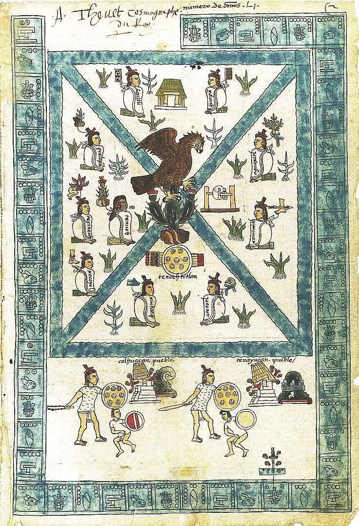
One of its pages lists what 22 towns around Tochtepec owed. Every six months: 1,600 decorated cloaks, 800 striped ones, and 400 women’s tunics and skirts. Every year: a warrior’s costume, gold, greenstone, 16,000 rubber balls, 8,000 handfuls each of blue, red and green feathers, 80 handfuls of quetzal feathers, 100 pots of a sweet-smelling resin, and 200 loads of cacao, the beans chocolate is made from. The numbers on the page are pictures too, and they go in twenties: a flag is twenty, a sign like a pine tree four hundred, a bag of incense eight thousand.
At the center of Tenochtitlan stood the Templo Mayor, a pyramid with two shrines on top, one to Huitzilopochtli, the Mexica’s own god, and one to Tlaloc, the god of rain. The Spanish tore it down in 1521 and the city grew over it. Then in February 1978 workers digging for the electricity company struck a great round stone. It showed a goddess, Coyolxauhqui, cut into pieces. In the Mexica story her brother Huitzilopochtli killed her, and here she lay at the foot of the stairs to his shrine. In the next five years archaeologists uncovered the temple’s seven stages, built one over another, and thousands of objects buried as offerings.
The temple was also a place where people were sacrificed to the gods. That isn’t only Spanish talk, which often made it bigger than it was. Beside the temple archaeologists have found what is left of a great tower of skulls, more than 650 so far, of men, women and children. How many people died there each year nobody knows.
Far to the north, beside the Mississippi near today’s St. Louis, another city rose around 1050. At its height, between 1050 and 1150, Cahokia held perhaps 10,000 to 20,000 people. They built about 120 mounds of earth; the biggest, Monks Mound, is about 30 m high, the largest earthen mound in the Americas. They grew maize, the crop first bred in Mexico. What they called their city is lost, and by about 1350 it was empty. Why is still argued.
The Inca road
The Inca called their land Tawantinsuyu, “the four parts together”. Its four quarters met at Cusco, high in the Andes of Peru at about 3,400 m, about as high as Namche Bazaar. The histories written down under Spanish rule say the Inca began their conquests in 1438 under a ruler called Pachacuti, and that within a century they ruled the Andes; radiocarbon dates from Machu Picchu, in use by about 1420, suggest the rise began a little earlier. At its height their land ran for about 4,000 km, from the southern edge of today’s Colombia to central Chile, over mountains, deserts and coast, and held millions of people.
It ran without money. People paid their tax in work: so many days in the fields of the state and the gods, on the roads, in the army. The state kept food in storehouses, and one of its staples was chuño, potatoes freeze-dried in the cold and sun of the high mountains, which fed officials, soldiers and the people working off their tax, and was kept against hunger.
To hold it all together the Inca built a road, the Qhapaq Ñan. Four main roads left the central square of Cusco, one to each quarter, joined by many smaller ones, partly on older roads of the peoples before them: more than 30,000 km in all. Along it stood storehouses and rest houses, and messages ran from station to station by relays of runners. Today it crosses six countries, and it is a World Heritage Site.
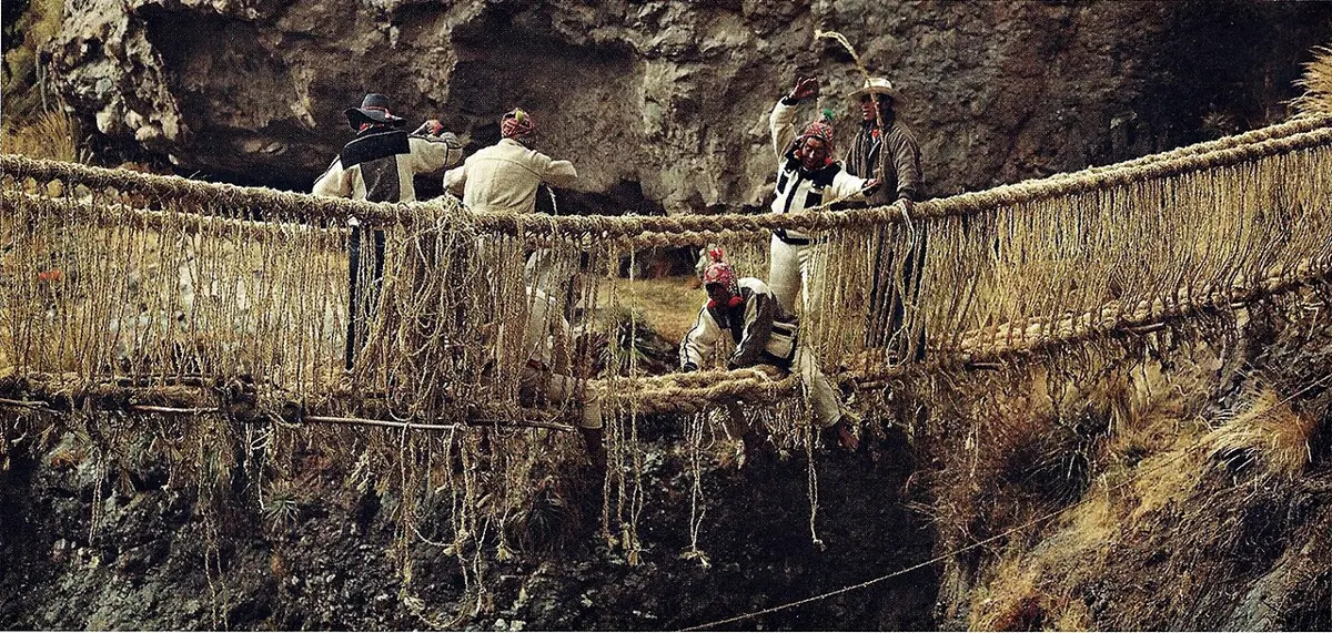
Where the road met a gorge, it hung on grass. One bridge of the old kind still hangs over the Apurímac River at Q’eswachaka, about 30 m across, made of ropes twisted from a tough mountain grass called ichu. Every year, in the second week of June, people from four nearby communities take the old bridge down and weave a new one.
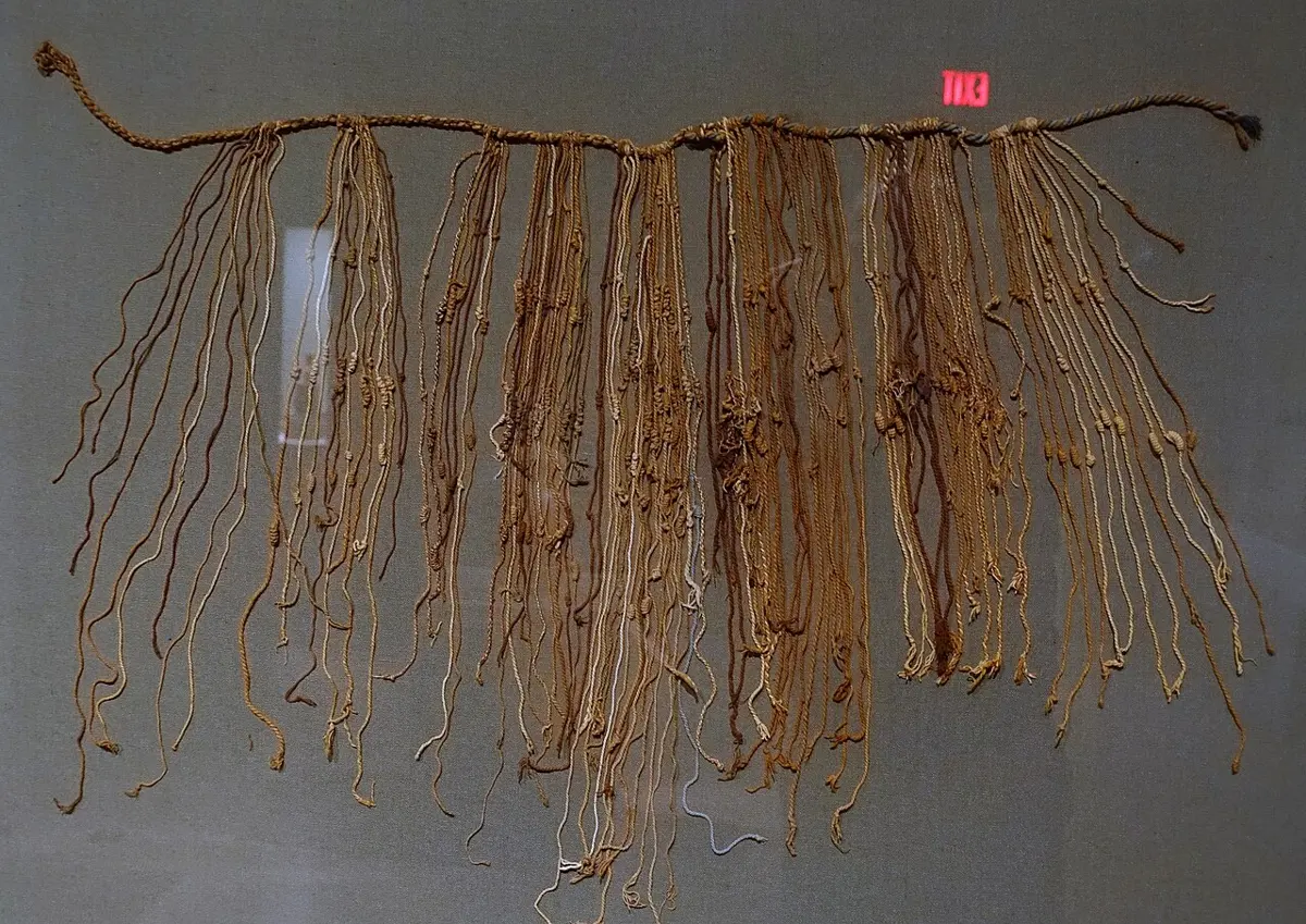
And the whole thing was run without writing, at least as we know writing. The Inca kept their records on khipu: a main cord with many cords hanging from it, mostly of cotton, with knots tied in them. Their numbers, worked out a century ago, are in tens, like ours. Clusters of single knots counted the tens, hundreds and thousands, the bigger ones nearer the main cord; a long knot, wound two to nine times, gave the ones from two to nine, and a knot shaped like an 8 stood for one. In 2005 two scholars studying 21 khipu from a single site, Puruchuco, showed that the totals of one were carried onto another, as accounts passed up from the people who counted to the officials above them. The keepers, called khipukamayuq, could read them back. About a thousand khipu survive. Whether any khipu holds words, a story or a name rather than numbers is the great open question, and nobody yet knows.
The Andes beside the Himalaya
A Nepali reading about the Inca keeps meeting home. Lake Titicaca, where the potato began, lies at about 3,800 m. The Andes are farmed in bands by height, as Nepal’s hills are: potatoes in the high, cool zone from about 3,100 to 3,500 m, and above it the cold grassland the Andes call the puna, where one frost-hardy potato grows as high as 4,300 m, higher than most of Nepal’s villages.
People have lived that high in both ranges for thousands of years, and their bodies have found different answers to the thin air. Andean highlanders carry more hemoglobin, the part of the blood that carries oxygen. Tibetan highlanders have less of it, but breathe more, about one and a half times as much at rest, and their breathing speeds up about twice as strongly when the air thins. Two peoples, the same problem, two answers.
How many people lived in all the Americas before Columbus? Nobody counted, so the answer can only be estimated, and estimates have swung wildly, from about 8 million to more than 100 million. One of the most careful, by the geographer William Denevan, adds up the regions to about 54 million, and he allows that it could be anywhere from 43 to 65 million; about a third of them lived in Mexico, and nearly as many in the Andes.
So the Americas were never an empty land waiting to be found. Over thousands of years, cut off from the rest of the world, their peoples bred maize and the potato, counted in twenties with a zero, wrote their kings’ lives in stone, built a city in a lake and another on the Mississippi, and ran an empire with knotted cords and roads along the Andes. Much of their record was burned, and much of what we know now comes from their own stones, books and cords, read again only in the last hundred years. When ships from Europe arrived, all of this met the rest of the world, and paid a terrible price for it.
Found a mistake? Please tell us.