
Most mornings in Nepal begin with a glass of चिया, tea boiled with milk and sugar. It is hard to think of anything more ordinary, or more Nepali. Yet the tea bush comes from the hills of southwest China, and its name came with it: चिया, like the chai of much of Asia, goes back to the Chinese word for tea.
The habit is also younger than it feels. Brian Hodgson, of the British Residency in Kathmandu, was growing tea from Chinese seed in the Residency garden in the early 1830s. In the 1860s the first tea gardens in Nepal were planted at Ilam, in the far east. But for a century after Hodgson, tea in Kathmandu was a drink for palaces and a few well-off homes, and most of it came from Calcutta. One of the earliest tea shops anyone in the city remembers, near the Dharahara, was selling it by 1945. Some of those first stalls wouldn’t serve people of the castes then called untouchable, or made them bring a glass of their own. Older people in Kathmandu say tea became an everyday drink only after 1951, वि.सं. २००७.
The sugar in the glass has its own road. Boiling cane juice down into hard crystals, which kept and could be carried, was worked out in India, and the Sanskrit word for them, शर्करा (śarkarā), which first meant gravel, went west with the sugar. It became shakar in Persian, sukkar in Arabic, zucchero in Italian and at last sugar in English. In Europe it began as a medicine for royalty, and before about 1650 most ordinary people there had never tasted it. Well before 1900 people of every class counted it a daily necessity, and in England much of it was stirred into tea. The anthropologist Sidney Mintz spent much of his life on what that meant. The cane was grown on Caribbean plantations, worked at first by enslaved Africans; the tea came from Asia; the people drinking it were workers in English towns. One sweet cup joined all three.
That is the idea of this whole book, in a glass of tea. Almost every ordinary thing has a history and a route. It began somewhere, at some time, and people carried it, traded it, copied it or forced it on others until it reached you. Follow enough of those routes back and you are following the story of the world, which is the story of how its peoples, far apart for most of their history, slowly came to be joined up.
The plate
At mid-morning comes दालभात. The rice in it was first tamed from a wild grass beside the Yangtze River in China, about 9,000 years ago. Wild rice grows in South Asia too, and the rice of the Ganges plain grew out of it. But its genes show that it was crossed, early on, with rice from China. When and how that happened is still argued.
The dal depends on which dal it is. Lentils, मुसुरो, were among the very first crops anyone farmed. People in what is now Israel were growing lentils, peas and beans more than 10,000 years ago, and lentils spread out from West Asia long before anyone could write about it. मास, black gram, and मुङ, mung, are South Asia’s own: farmers in India tamed them from wild plants that grew here. Not everything on the plate came from far away.
The तरकारी is another matter. The potato in it was bred by farmers in the Andes mountains of Peru, and the chili in the अचार beside it by farmers in Mexico. Until about five hundred years ago, nobody in Asia had seen either. How they crossed an ocean, and what that crossing did to the peoples who had bred them, is one of the biggest stories in world history, and this book comes to it later.
Seen this way, the whole world’s food rests on a short list of travelers. People grow more than 6,000 kinds of plants for food, yet fewer than 200 of them matter much, and just nine make up two-thirds of all the crops grown on Earth, by weight. Rice, maize and potatoes are among the nine, and they began on three different continents.
How anyone knows
How can anyone say where a crop began, thousands of years before writing? The first person to set out to answer that for every crop was a Russian botanist, Nikolai Vavilov. Between 1916 and 1933 he and his teams made 115 collecting journeys to 64 countries on five continents, gathering seeds. His rule of thumb was to look for the place where a crop grows in the most different kinds, among its wild relatives. He published a first answer in 1926 and kept redrawing it. In its best-known form, from 1935, the world’s crops began in eight great centers, from China for the soybean to South America for the potato.
His seeds filled a great seed bank in Leningrad, today St Petersburg. In 1940, out collecting in Ukraine, he was arrested, and in January 1943 he died of starvation in a prison in Saratov. By then Leningrad had been surrounded by the German army for more than a year, and its people were starving too. The scientists guarding his collection were surrounded by seeds and potatoes they could have eaten. They didn’t. In the siege’s first winter more than thirty of the institute’s people died. Among those who starved were the keepers of its rice, its oats and its peanuts.
Scientists still look where Vavilov looked. Now they also read the DNA of crops and their wild relatives, and date the seeds and grains that archaeologists find in old hearths and storage pits. That is how rice’s story was worked out, and the potato’s: in 2005 one such study found that every potato grown in the Andes today goes back to wild potatoes of Peru, where earlier guesses had looked in several places.
The numbers on your phone
Beside the plate there is probably a phone, and on it the time: 10:05, say. The digits 0 to 9 are the same in nearly every country, and they come from India. So do Nepali’s own ० to ९. Both families of digits descend from the Brahmi numerals that Ashoka, the great Maurya emperor, had carved on his stones about 2,250 years ago.
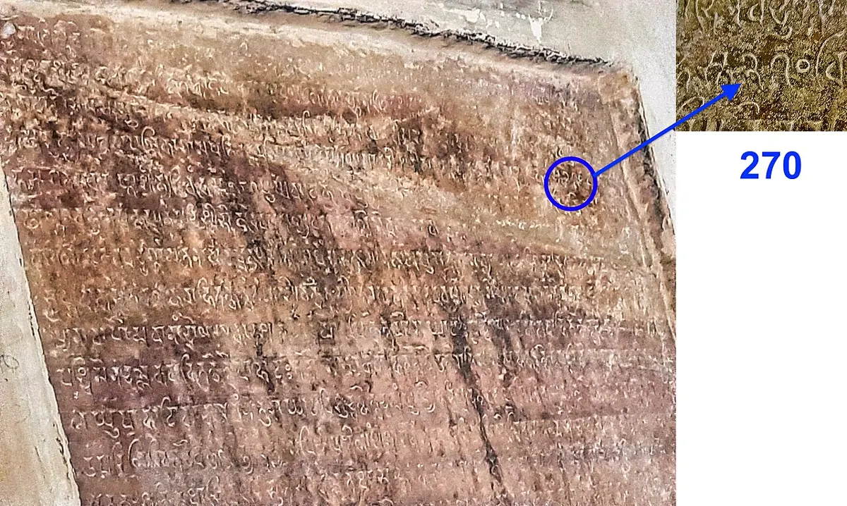
What made them powerful came later. It was writing a number by place, so that the same 2 means two in 2, twenty in 20 and two hundred in 200, with a sign for nothing to hold an empty place. That was in use in India by about 600. The oldest stone showing it that nobody disputes is at Gwalior, in central India, from 876. It records gifts to a temple, among them a garden to grow flowers for 50 garlands a day, and the numbers 270 and 50 are cut almost as you would write them, the zero a little smaller and set a little higher.
The idea traveled west. In Baghdad, in the 800s, a scholar at the caliph’s House of Wisdom, Muhammad al-Khwarizmi, wrote a book explaining the Indian way of reckoning. The Arabic original is lost, but a Latin version survives, and its title begins with his name, Algoritmi. From it comes the word algorithm, a step-by-step recipe, which is what every program on your phone is. Nearly four centuries later, Leonardo of Pisa, schooled in North Africa, where his father looked after Pisa’s traders, learned what he called the art of the Indians’ nine symbols. In 1202 he wrote a book that taught them to Europe, and he is remembered today as Fibonacci. Europe went on calling them Arabic numerals. Arab scholars had called the same reckoning Indian.
So the time on a phone in Nepal is written in signs that went from India to Baghdad, to North Africa and Italy, and from there around the world, and came home.
Which way is up
On almost any map of the world on a classroom wall, Europe sits in the middle near the top, the Americas off to the left, and Nepal a small shape up and to the right. That is a choice, made for reasons, and the reasons are history too.
The shape most people know comes from a map that Gerardus Mercator, a Flemish mapmaker, published in 1569 “for the use of sailors”. On it, a course steered by a single compass bearing is a straight line, which is what a ship’s navigator wants. The price is that the farther a land lies from the equator, the more it is stretched. Greenland looks about as big as Africa; Africa is really 14 times bigger. Most maps on phones still use his way of drawing the world.
Why Europe in the middle? Partly because for centuries the maps that spread around the world were drawn and printed there, and a mapmaker puts home in the middle. Then, in 1884, delegates from more than twenty countries met in Washington and voted, 21 to 1, to count longitude from a line through Greenwich, near London. San Domingo, today the Dominican Republic, voted no, and France and Brazil didn’t vote. The strongest case for Greenwich was that the world’s ships already used it: a table read out at the meeting counted two-thirds of all ships, with nearly three-quarters of all the world’s shipping by tonnage, already reckoning their longitude from Greenwich. Ever since, the line at zero has run through London, and a map cut along the opposite line, out in the Pacific, has Europe near its middle.
Other mapmakers chose other middles. In 1154 the geographer al-Idrisi finished a great book of maps for Roger II, the king of Sicily, and as many mapmakers in the Muslim world did, he put south at the top. In Beijing in 1602, Matteo Ricci, an Italian priest, and the Chinese scholars he worked with printed a map of the world for the Wanli emperor with China and the Pacific Ocean in the middle.
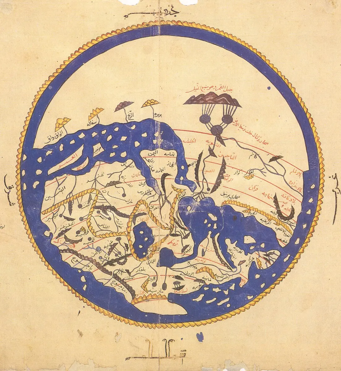
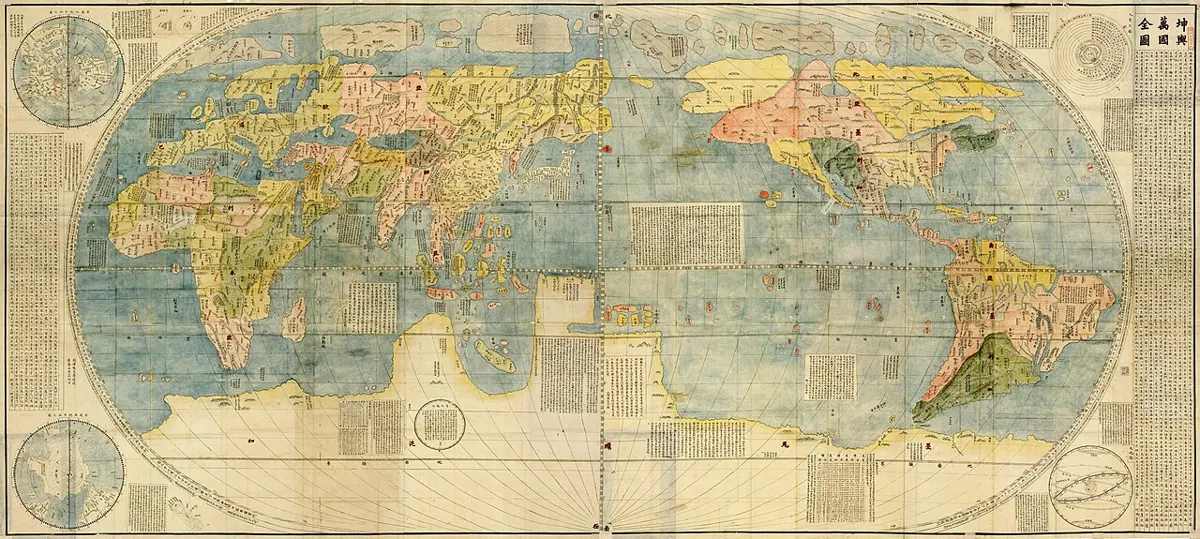
None of these maps is wrong. A round world has no top and no middle, and every flat map has to stretch it somewhere and cut it somewhere. Flat Maps lets you try eleven ways of doing it. Turned so that Nepal is in the middle, the map is just as true, and the world looks rather different: a short walk from Tibet, a long way from London, with India’s ports and China’s cities both close by.
The story from here
This book tells the world’s story in order of time, from the first people to walk out of Africa to the line of travelers at Tribhuvan airport. It doesn’t march from Greece to Rome to the rest of Europe and treat everyone else as a side road. It looks at many parts of the world at once, with South Asia, China, Tibet and West Asia there from the start, because that is how history happened: everything at the same time, in many places, most of which knew little or nothing of the others. Slowly, by trade and travel, by war and by ideas, they came to know each other, and each part of the book ends with the world a little more joined up than it began.
Nepal is where we stand, not the middle of the story. Where the Himalaya mattered, the chapters say so; where nobody here had heard of what was happening, they say that too. It keeps apart what the evidence shows, what tradition tells, and what historians still argue about. And the plate comes back: in a later chapter, the chili, the potato and maize cross the ocean, and the book ends with it once more.
So the things on the table are a record of people: of farmers who tamed wild plants in a dozen places, of traders, travelers and scholars who carried them and their ideas along, and of others who were forced to grow them for someone else. Some, like मास, began close by. Most came by long roads, and some of those roads are thousands of years old. Follow them back far enough and every one leads to the oldest road of all, the one people walked when they first left Africa.
Found a mistake? Please tell us.