
On many clear winter mornings in the hills of Nepal, the grass is wet. Nobody watered it and no rain fell in the night, yet every blade carries a row of drops. That water was in the air all along, invisible, and the cold night simply made it show itself. A cold glass on a hot afternoon does the same trick, beading on the outside though the water inside never leaks.
Rain is the same trick played on a grand scale, and it comes down to a few plain steps. Water from seas, rivers, fields and leaves goes up into the air as vapor, an invisible gas. Warm air can hold a lot of vapor, and cold air much less. When air rises, it cools. If it rises far enough, it gets too cold to hold all its vapor, and the extra turns back into tiny drops of water: a cloud. When the drops in a cloud grow big enough to fall, it rains.
So the whole question of where it rains, and how much, turns on one thing: what makes air rise. There are only three common answers, and one of them explains why a village on one side of a mountain can be among the wettest places in Nepal while a town on the other is nearly a desert.
Water in the air
Some air always has water in it. Over the ocean, sunshine and wind lift water off the surface all day, and the same happens, more slowly, over a wet field or a pond. This is evaporation: liquid water turning into vapor. Plants add their share, drawing water up from the soil and breathing it out through their leaves.
How much vapor the air can hold depends almost entirely on how warm it is. A cubic meter of air at 30 °C, a hot afternoon in the Terai, can hold about 30 grams of water before it is full. At 20 °C it can hold about 17 grams, and at freezing about 5. Roughly, every 10 °C of warming nearly doubles what the air can carry. That’s why a warm sea is such a good source of rain, and why very cold air, even when full, carries little water.
Air that holds all the vapor it can is said to be saturated. Most air holds less than that, and how full it is, as a percentage, is its relative humidity. Cool any air enough and it becomes saturated. The temperature where that happens is its dew point. Cool it further and the vapor has to go somewhere, so it condenses: the gas turns back into liquid water. Going up, the water carries the sun’s heat with it, and when it condenses that heat is given back to the air. Weather runs on this exchange.
Condensation needs something to condense on. Water vapor can’t easily form a drop out of nothing. Real air is full of specks too small to see, blown dust, salt from sea spray, smoke, and every cloud droplet has one of them at its core.
Near the ground the cooling comes from the ground itself. On a clear, still night the earth loses its heat straight to the sky, and the air touching it cools. Where it cools below its dew point, water condenses on grass, leaves and cars: dew, शीत. If the surface is below freezing, the vapor turns straight into ice without being water first, and the morning finds frost, तुसारो, fine white needles and feathers of ice. Clouds would blanket the ground and keep it warm, and wind would stir the cold layer away, so dew and frost come on calm, clear nights.
A change straight from gas to ice, or from ice straight back to gas, has its own name: sublimation, ऊर्ध्वपातन, used for both directions. Frost is one way. The other is why snow on a high, dry pass can shrink away over the days without ever melting into a puddle.
When a thick layer of air near the ground cools past its dew point, the droplets hang in it instead of settling on things. That is fog, कुहिरो, which is simply a cloud that touches the ground. If you can still see a long way through it, the thinner haze of droplets is called mist, हुस्सु. A valley full of fog, seen from a ridge above it, is a white sea with the hilltops standing out of it.
From cloud to rain
A cloud is made of droplets about a fiftieth of a millimeter across. They are so small that the slightest rising air holds them up, which is why a cloud floats. A typical raindrop is about 2 mm across, a hundred times wider. Its volume is a hundred times a hundred times a hundred greater, so it takes about a million cloud droplets to make one raindrop. Plenty of clouds never manage it.
Clouds have two ways of making rain. In the first, the droplets bump into each other and merge. A slightly bigger droplet falls a little faster, sweeps up smaller ones in its path, grows, falls faster still, and gathers more. In warm clouds this is how rain forms.
The second way starts with ice. High in a cloud, water can stay liquid well below freezing, as long as it has no ice to freeze onto. When a few ice crystals form among these chilled droplets, the crystals grow and the droplets around them shrink, because vapor settles more readily on ice than on water. The Swedish meteorologist Tor Bergeron worked this out in the 1930s with Walter Findeisen, and it is thought to start most of the world’s rain. The crystals grow into snowflakes and fall. If the air below is warm they melt, and arrive as rain. So the rain on a warm day may well have begun as snow, high above.
If they stay frozen all the way down, they land as snow, हिउँ. Snowflakes are clumps of ice crystals stuck together. A Vermont farmer named Wilson Bentley was the first known to photograph them in detail, through a microscope, starting on 15 January 1885; he caught the flakes on black velvet and worked fast before they melted. He went on to take more than 5,000 such pictures, and he is the reason people say no two snowflakes are alike.
Between rain and snow lies sleet: drops that melt on the way down, then freeze again in a cold layer near the ground and land as pellets of ice. At the other end of the scale are the finest drops, under half a millimeter, which fall as drizzle.
Hail, असिना, is something else, and only one kind of cloud makes it: the towering thundercloud, whose inside is a column of air rushing upward. Raindrops carried up that column freeze. Each frozen pellet then collects the chilled water it meets, which freezes onto it, and it grows until the rising air can’t hold it any more, and it falls. Cut a big hailstone in half and you see rings, like an onion. The old picture had the stone riding up and down the cloud, one ring for each trip. Storm scientists now say it isn’t that simple: the rings mostly record the stone passing through parts of the cloud with different temperatures and different amounts of water, often as it drifts sideways across the updraft. Where it freezes water fast, air is trapped and the ice turns milky, and where it freezes slowly, the bubbles escape and the ice comes out clear.
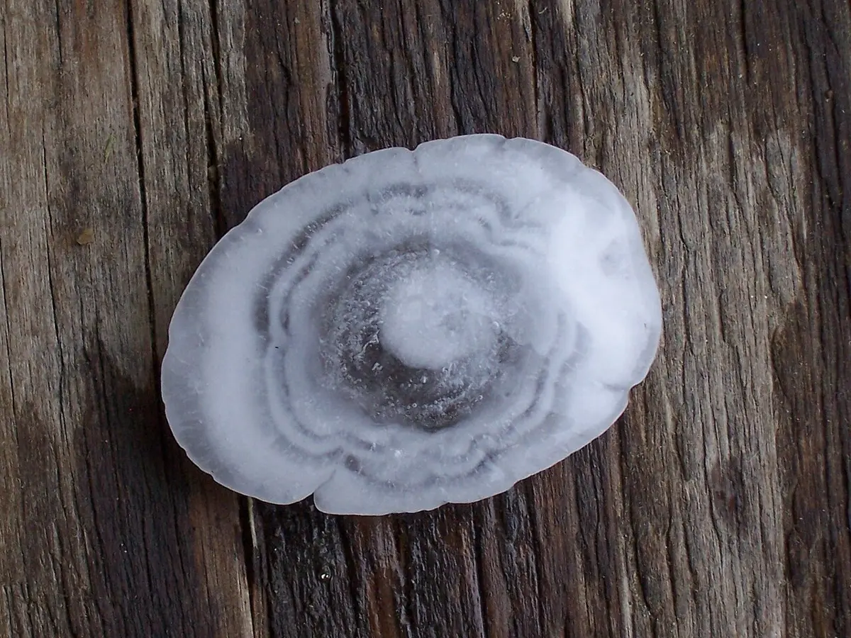
The heaviest hailstone ever weighed fell in Bangladesh, in the Gopalganj district, on 14 April 1986: just over a kilogram. The deadliest hailstorm on record struck Moradabad, on the plains of northern India, on 20 April 1888, and killed 246 people. Both came in April, in the hot weeks before the monsoon.
Three ways up
Everything so far needs rising air. Air doesn’t rise on its own, though. Something has to lift it, and there are three common ways.
The first is heat from below. On a sunny day the ground warms, and so does the air touching it. Warm air is lighter than the cooler air around it, so a bubble of it rises, the way a hot-air balloon does. If the air is damp enough, it reaches its dew point on the way up and a cloud begins, puffy and white with a flat base at the height where the condensing starts. On a really hot, damp afternoon the heat given back by the condensing water keeps the bubble warmer than its surroundings, so it goes on rising, and the cloud builds into a tower many kilometers high, dark underneath, with thunder, a short heavy shower, sometimes hail. This is convectional rain. It is the daily afternoon storm of the rainforests near the equator. Nepal’s thunderstorms of spring, which come in the hottest weeks before the monsoon, look very much like the same thing.
The second is a mountain in the way. When wind blowing off the sea meets a range of hills, the air has nowhere to go but up the slope. It cools as it climbs, clouds form against the mountainside, and rain falls on the side facing the wind. This is relief rain, also called orographic rain, from the Greek for mountain. It has made some of the wettest places on Earth. Cherrapunji, a small town on the Khasi Hills of northeast India, sits where the monsoon wind comes in off the plains of Bangladesh and runs straight into a wall of hills. Between August 1860 and July 1861 it got 26.47 meters of rain, the most ever measured anywhere in twelve months. Mawsynram, about 15 km to the west on the same hills, is often called the wettest place on Earth now, with nearly 12 meters in an average year.
The third is a front, a boundary between two great bodies of air, one warm and one cold. Cold air is heavier, so where the two meet, the cold air stays low and pushes in under the warm air like a wedge, or the warm air slides up over the cold. Either way the warm air is lifted, and clouds and rain form along the boundary, often over a wide area and for hours. Fronts are the everyday rain-makers of lands farther from the equator, where cold air from near the poles meets warmer air, and the idea of them came from a group of meteorologists in Bergen, Norway, Bergeron among them. Air also rises where winds flow together from different sides and have nowhere to go but up, as they do around a storm’s center, so geography books often put fronts and great storms together as cyclonic rain.
Nepal gets all three. Spring brings its afternoon storms. The monsoon is relief rain on an enormous scale. And sometimes a cyclone from the Bay of Bengal drifts far enough north to reach it. Cyclone Hudhud struck India’s east coast at Visakhapatnam on 12 October 2014, weakened as it moved inland, and its remains reached the Himalaya. The wet air was forced up against the high mountains, and from 13 to 15 October heavy snow fell across the Annapurna region and far beyond it. Hundreds of trekkers, guides and herders were caught in the snow and avalanches, many near the Thorong La pass, at 5,416 meters, and at least 43 people died. A storm born over a warm sea had come down as snow in the Himalaya.
Two sides of one range
Air that has climbed a mountain has to come down the other side, and coming down does the opposite of going up. Sinking air is squeezed by the heavier air below it and warms, about 10 °C for every kilometer it drops. As it warms it can hold more water, so it takes up what it can: clouds melt away, and nothing condenses. The air that spills down the far side of a range is drier than when it started, and often warmer. Where this happens year after year, the land behind the mountains is a rain shadow.
Rain shadows lie behind mountains wherever a wet wind blows steadily against them. In the northwest of the United States, wind off the Pacific runs into the Olympic Mountains. Aberdeen, on their wet southwestern side, gets about 2,200 mm of rain a year, while the country tucked behind them to the north and east, around Sequim and Victoria, gets roughly a quarter of that. On India’s west coast the Western Ghats catch the same monsoon that reaches Nepal: the coast below them is drenched every summer, and the Deccan Plateau behind them is far drier.
Nepal has a famous one of its own on the Annapurna range, north of Pokhara, where Lumle and Jomsom, about fifty kilometers apart, live with very different rain.
Going north, the rain grows as the land rises toward the range, then almost stops behind it. The difference is sharpest in the monsoon months, when nearly all the wet air arrives from the south and the range catches nearly all its water. In winter, when what little rain there is comes on other winds, the two sides are much closer.
The same thing happens all along the Himalaya, and Tibet, behind the whole range, is dry for the same reason. Along the Annapurna range it is written plainly on the land: green and dripping on one side, and on the other, bare brown hills. What remains is why the wet wind comes at all, and why it comes when it does.
Found a mistake? Please tell us.